Crown Point State Historic Site lies at the tip of a peninsula, jutting northward into Lake Champlain, a place at one time quite remote with a unique history at the crossroads of war, laced with more than a few tales of folklore, mystery, and imagination befitting the Halloween season.
A calico patchwork in fall of orange, red and gold, the Adirondack Mountains flank the western shore of the lake while the Green Mountains of Vermont rise along the eastern side, just beyond the farmland of the valley floor. It is a majestic, glorious landscape with a sky so expansive, it is a daily reminder of our small place in this universe, a place where young 18th century soldiers who once manned this stone fortress must have felt far removed from the rest of the world they knew
As twilight approaches, the breath and expanse of this geography folds into itself as the darkness envelops the mountains and lake. The mere depth of the night is unnerving enough but without the benefit of sight, sounds are amplified in the deep black of the understory of the trees. Owls calling above and rustling in the brush below are reminders of how vulnerable we seem in the vast darkness of this wilderness even today.
Located in Essex County, Crown Point has been on both the historic State and National Registers of Historic Places since 1976, significant as the location of ruins of the French-built Fort St. Frederic (1734) and the British fort, H.M. Fort at Crown Point (1759), the largest fortification erected on the North American continent at the time. The French and British fought bitterly for decades over control of this place – precisely because of the sightlines the majestic landscape could afford those who wanted command of the waters of Lake Champlain, pointed like a silver dagger from Canada into the heart of Colonial New England.
NYS Office of Parks, Recreation and Historic Preservation endeavors to preserve the Crown Point ruins in their current state as part of the 1910 stewardship agreement when New York State was gifted the property. One of the defining features of the site are the officers and soldiers’ barracks in the British parade grounds, stones silently stacked and hidden behind the fort walls. The structures are missing stairways, second story flooring and roofs; there is an ethereal quality upon viewing them, when conscious of the intended permanence of these structures and the ravages of time since people lived, worked, suffered and died within.
Take the darkness of night, mix with centuries old ruins, top off with harrowing local lore and this proves to be the perfect elixir of sinister, spooky, and spine-chilling. Visitors to the Haunted Histories at the Forts scheduled for October 29 will be welcomed with cider and donuts donated by local orchards and greeted with the first of many true, but unexplained tales at the site.

Present day meets the past in the most unfortunate of coincidences – this is not the first epidemic witnessed at Crown Point. The winter of 1775-76 found Boston in the throes of a smallpox epidemic. Many know of the story of the artillery recovered from Crown Point and how General George Washington used the guns to drive out British troops during the Siege of Boston; however less well known, is at the time of liberation, the city was also ravaged by a pandemic of smallpox.
Most British troops had been inoculated or had the smallpox previously and were immune. In Europe, where smallpox was pervasive, most would have been exposed to the disease and likely had antibodies to protect them. 1 This protection was not the case for Indigenous peoples nor the colonists, and the disease persisted in Boston throughout the beginnings of the war, peaking in July 1775 and gradually subsiding by September of that year. At that time, little was known about virology, and isolation was used as the primary control of transmission.
But then as now, that was only the first wave of the epidemic in the Colonies. During the summer of 1775, the Continental Army launched the ill-fated Northern Campaign in an attempt to dislodge British forces in Canada. Crown Point became the launching pad for these Patriot attacks directed at British-controlled Montreal and Quebec on the St. Lawrence River.
The second wave of the epidemic came in the midst of this campaign in 1776. Patriot Major General John Thomas, Commander of the Army in Quebec, died of the disease in the summer of 1776 as the disease-weakened Continental Army was repelled from Quebec. By that point, an estimated 3,000 men of the Northern Army were sick, most with smallpox.2 After a five-month siege on Quebec, defeated, diseased colonial troops withdrew to Crown Point where a hospital was set up.
William Scudder, an officer serving in the New York 4th Regiment during the campaign, wrote in his journal:
“In June, I had the command of some batteaux…that were loaded with provisions to go to Crown Point, where our army then lay, under the command of General Sullivan, having retreated from Canada, – an such a scene of mortality was exhibited at that place, I never had beheld. The hospital I judged to be about one hundred and fifty feet in length; on the lower floor in two ranges on each side, the poor sick and distressed soldiers. Their disorder was chiefly the small-pox – Some groaning and begging for water, some dying and other dead and sewed up in their blankets; let it suffice to say, that by the middle of the afternoon they would begin to carry the dead from the hospital; I counted twenty-one carried out at one time, and it was common to bury fifteen or twenty in a day.” 3
Archeologists have been working at Crown Point from the mid-1950’s to the present. In addition to first-hand accounts of those laying their final rest here, there are the Fort St. Frederic parish birth and death records of the French that inhabited the site prior to both the British and Colonial occupations. Despite all the historical records, and the extensive archeological work throughout the 21st century, no evidence of human remains have ever been found. The French were Catholic, which prohibited them from burning the bodies, and even if the diseased soldiers had been disposed of by incarceration, there would be carbon remains. No reasons can be found to explain this mysterious absence.
It’s not only the history that cannot be explained, but the mountains and lakes that surround Crown Point that are just as elusive and mystifying, as evidenced proven by both news reports and stories local inhabitants have passed down through generations.
Long before any European settlers arrived in the area, both the Abenaki and the Haudenosaunee native people had stories about a large creature inhabiting the lake. It was called Ta-to-skok by the Abenaki, a word meaning creature with two tusks. Early in the 18th century, Abenakis warned French explorers about disturbing the waters of the lake, so as not to disturb the serpent.
Samuel de Champlain’s diary reveals the following entry:
“. . . [T]here is also a great abundance of many species of fish. Amongst others there is one called by the natives Chaousarou, which is of various lengths; but the largest of them, as these tribes have told me, are from eight to ten feet long. I have seen some five feet long, which were as big as my thigh, and had a head as large as my two fists, with a snout two feet and a half long, and a double row of very sharp, dangerous teeth. Its body has a good deal the shape of the pike; but it is protected by scales of a silvery gray colour and so strong that a dagger could not pierce them.”
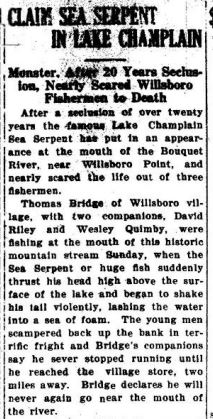
Never one to miss a trick, showman P. T. Barnum offered a reward of $50,000 in 1873 for “hide of the great Champlain serpent to add to my mammoth World’s Fair Show.” 4 No one ever claimed it.
The Regional Office of Sustainable Tourism lists many 19th century sightings, with 1873 being a particularly robust year. A New York Times story reported that a railroad crew had seen the head of an “enormous serpent” in Lake Champlain, with bright silvery scales that glistened in the sun. In July that same year, Clinton County’s Sheriff, Nathan H. Mooney, reported an “enormous snake or water serpent” he thought was 25 to 35 feet long. Then in August, the steamship W.B. Eddy encountered Champ by running into it. The ship nearly turned over, according to many of the tourists on board. Never one to miss a trick, showman P. T. Barnum offered a reward of $50,000 for “hide of the great Champlain serpent to add to my mammoth World’s Fair Show.” 4
The stories continue through the decades, marked by a roadside sign upon entrance to the neighboring town, Port Henry, where they celebrate Champ Day each summer, hoping to catch sight of him again.
Fun folklore or relative of Nessie, world famous occupant of the Scottish Loch Ness? Fast-forward to contemporary times, and a quick Google search on Champ turns up what may be the only existing photo of his presence, taken by Sandra Mansi in 1977 while vacationing in northern Vermont. 5


Ronald Kermani, a former investigative reporter for the Times Union, whose family has a camp on Lake Champlain. He has spent summers here for the past five decades and told of his experience, at 7:10 a.m. on July 2, 1983, when he was fishing in a rowboat with a girlfriend.
He said he saw a creature about 30 feet away with “three dark humps — maybe 12 inches thick — protruding about two feet above the surface … two or three feet apart.”
Kermani wrote: “We watched in disbelief for about ten seconds. The humps slowly sank into the water. There was no wake, no telltale sign of movement. Unexplained. Eerie. Unsettling.”
He did not get a picture because he did not have a camera. Ever since, Kermani, who is retired and lives in Guilderland, has carried a camera in the boat with him when he is out on the lake — just in case. 6
It’s not just below the surface that menaces. In the mountains to the west of the peninsula are indigenous burial grounds. Coot Hill near Port Henry has long been a reported locus of visions, vengeful murders, and accumulation of gruesome accidents. Maybe they should have looked for property elsewhere to settle.
There’s not enough space to even address the French werewolves, apparitions appearing in the parade grounds, drowned Scottish soldiers or sounds that emerge and then follow a person as they try to retreat. History books can explain some, but not all. Coupled with deep darkness and imagination, that makes for a chilling trapse across the grounds at Crown Point, particularly in the dark of night. For the Haunted History event, 18th century costumed interpreters will portray the restless soul of French settlers, who would have arrived at Fort St. Frederic with stories of their own to tell.
Keep your friends close and your flashlight on!

Post by Lisa Polay, Site Manager, Crown Point State Historic Site.
SOURCES
1 Gil Jr.l, Harold B. Colonial Germ Warfare. Colonial Williamsburg Journal. Spring 2004.
2 Fenn, Elizabeth A. The Great Smallpox Epidemic. History Today. Vol 53: Issue 8. August 2003.
3 The Journal of William Scudder, an officer in the late New York Line, who was taken captive by the Indians at Fort Stanwix, on the 23rd of July, 1779, and was holden a prisoner in Canada until October, 1782, and then sent to New York and admitted on parole. Evans Early American Imprint Collection
4 Lake Champlain Region (ROOST), https://www.lakechamplainregion.com/heritage/champ
5 Grondahl, Paul Champ: Hook, Line and Sinker,. Albany Times Union. Dec 28, 2012.
6 Grondahl, Paul Champ: Hook, Line and Sinker, Albany Times Union. Dec 28, 2012