Raptor Migration and Hawk Watching

When we think about spring and fall in the northeast, we often dwell on the extraordinary changes that occur to our trees and other plants. In the spring, we yearn for green to replace the barren gray and white of winter; in fall we marvel at the warm oranges, reds, and yellows that are on display as our trees prepare for winter. But there is an equally amazing change that is occurring at the same time, one we often fail to realize because we simply don’t look up: the mass migration of raptors. Whether it is the sheer majesty of a bald eagle, the raw power of a northern goshawk, the pure speed of the peregrine falcon, or the extinct-ness of the Velociraptor, raptors have captured the minds and imaginations of people and cultures for generations. Raptors, also called “birds of prey,” include eagles, falcons, hawks, vultures, ospreys, harriers, and owls.

Raptor-watching, normally referred to as “hawk watching,” is a great way to spend a spring or autumn afternoon and can be enjoyed in many of our State Parks. Hawk watching is a draw for both veteran and novice bird watchers alike. Raptors are highly visible during their migration as they soar through the skies, unlike songbirds who hide in dense shrubs and tree tops. If you go to popular hawk watching sites during migrations (www.hawkcount.org), you will often find other observers and official hawk counters. These fellow birding enthusiasts are always eager to help you identify the shapes and flight patterns of certain groups and species. With a bit of practice, you’ll be a veteran in no time!

Migration

Migration is no joke and (as you can imagine) can be exhausting. Some species, such as broad-winged hawks, travel over 4,500 miles in about 9 weeks. Why do these birds go through all this trouble, anyways? Your first guess might be that the birds are escaping the cold. However, if so, then why don’t they stay closer to the equator, where it is always warm? The suggestion that temperature triggers migration is a very common misconception and is often connected to human behavior. Many northerners head south for warmer climates to escape the winter chill. Those who spend their entire winters in the south are even given the name “snowbirds.” With bird migrations, they aren’t escaping the cold; they are often migrating due to the lack of food availability in the winter.

Picture this (shouldn’t be hard for us Northeasterners)… the sun starts setting lower in the sky, the days grow shorter, and the frigid air from the north starts blowing. Plants go through an amazing transition. Annual plants who have dropped their seeds have reached the end of their life, while perennial plants drop their leaves, transferring their energy into their roots and stems to outlast the winter. The world feels a bit barren with the browns and whites of winter. Those plants provide food for insects and many small mammals. When the plants retreat, these small animals follow suit with either long slumbers or feeding off their stockpile of nuts and seeds in their winter dens. Even our ponds and streams can’t provide a bounty, for water denizens are sealed under a thick layer of ice. If you were a raptor, would you stay around and risk not finding food, or would you soar south where food is still plentiful? That said… not all raptors leave. Driving along major highways, you’ll often see red-tailed hawks perched high above, waiting for a mouse or rabbit to make the mistake of exposing themselves. Food is still around, it is just harder to come by. Raptors who do fly south must compete with southern resident birds for food and roosting sites. This added competition is OK though, for the adult raptors only need to worry about feeding themselves. However, when the desire for mating and offspring arises, these southern retreats don’t provide enough food to feed hungry young bellies. So, adults return to their summer breeding grounds… right when their unsuspecting prey emerges from their long winter retreat.

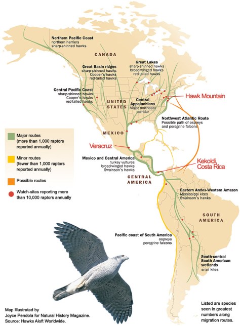
Like humans, raptors concentrate along specific routes while traveling long distances. So, just like you would find more people driving cars on highways than backroads, you’ll find more raptors along flyways. Here in the Northeast, we are part of the Atlantic flyway. Raptor flyways are normally found over level terrain. Mountains, large lakes, and oceans create obstacles that raptors cannot easily cross. Mountains do have a very important role to play, besides being simple barriers. In North America our mountain ranges run north-south. When cross winds hit these ridge an updraft is created, which raptors then use to help them soar and stay aloft. These updrafts mean raptors need to flap their wings less, conserving an enormous amount of energy for their long trip.

flyways
Image courtesy of Hawk Mountain

Updrafts are extremely helpful… when the wind actually blows. So, what do raptors do in early fall, when the sun is still high in the sky and the winds relatively calm? Physics, my friend. Even if you aren’t an avid hawk watcher, you have probably noticed vultures or hawks flying in large circles with their wings wide and high in the sky. This trick is called soaring flight and it is raptors mastering flight on thermal air currents. Thermal air currents, or thermals, are created when air heated by the sun rises from the ground into the sky. Thermals are often formed along the slopes of hills, but can also form over flat ground. As this warm air rises it cools and condenses, forming puffy, beautiful clouds. If you have a sunny, warm day with puffy clouds, it is also probably a good day for thermals and a good day for raptors to soar overhead.

updraft-thermal
Image courtesy of Hawk Mountain

Thermals typically do not form over open water; water releases heat evenly and slowly. Without any type of thermal or updraft most raptors must resort to flapping their wings, which uses an extraordinary amount of energy. If raptors decide to migrate over large bodies of water and need to flap the entire way, they are taking a huge risk: if they run out of energy, they will most likely drown. So, when raptors come across a large body of water while migrating, they typically hug the shoreline until they find a short way to cross. These short crossings often form bottlenecks where thousands of raptors pass through every year. One of the largest bottlenecks in the world happens to be in Veracruz, Mexico, where tens to hundreds of thousands of raptors migrating from central and eastern North America pass through, trying to skirt between the Gulf of Mexico and the Sierra Madre Oriental mountain range.

Identification

The identification of raptors hundreds of feet in the air, where you can often only see a silhouette against a cloud, can seem… daunting. Luckily, with a bit a practice it might be easier than you feared. Hawk watchers often utilize an identification protocol called the SPASMATIC method:

Shape Relative sizes and proportions of wings, tail, and head
Pattern/plumage Contrasting patterns of dark and light
Actions How does the bird fly or what is it doing?
Size How big is the bird in comparison to other birds?
Multiple
Attributes
Use as many of the above characteristics as possible
Trust
In the
Concept
Believe in your ability to judge these characteristics

Shape and size are often the key characteristics you need to focus on and can be used to identify or narrow down most raptors in flight in the Northeast. Raptors (excluding owls) are broken down into 7 main shape groups: accipiters, falcons, eagles, buteos, vultures, osprey, and harriers. Each group has distinctive characteristics to help you with your identification venture.

Shape and size are often the key characteristics you need to focus on and can be used to identify or narrow down most raptors in flight in the Northeast. Raptors (excluding owls) are broken down into 7 main shape groups: accipiters, falcons, eagles, buteos, vultures, osprey, and harriers. Each group has distinctive characteristics to help you with your identification venture.

Hawk_silhouettes2
Hawk silhouettes, image from Learn.org

Accipiters (sharp-shinned hawk, cooper’s hawk, northern goshawk) typically chase and feed on songbirds in woodlands with closely spaced trees, so when in flight they have short, rounded wings and long narrow tails.

1024px-Sharp-shinned_Hawk_(Accipiter_striatus)
Sharp-shinned hawk, note the long tail and rounded wings. By Steve Berardi, accessed from Flicker

Buteos (red-tailed, broad-winged, red-shouldered, and rough-legged hawks) have broad-shaped wings for soaring and perching on high branches.

Red-tailed_hawk_(16381245001)
Red-tailed hawk, note the dark band of feathers across the belly. This can be seen in all birds, photo by USFWS Mountain-Prairie

Falcons (American kestrel, merlin, peregrine falcon) often catch prey in mid-flight in open spaces and depend on speed to capture swift prey, so when in flight you can see that they have pointed wings.

An american kestrel ( perched on a wooden post.
American kestrel

Harriers have broad, strong wings held in the distinctive v-shape (or dihedral shape), which allows them to fly low and slow at ground level, typically around grasslands and marshes. Northern harriers are the only harriers found in our region.

Northern_harrier_(12344138524)
Northern harrier, photo by U.S. Fish and Wildlife Service Headquarters

Vultures (turkey and black vultures) have long and broad wings, which aids in soaring over fields and woods while searching for carrion. Turkey vultures hold their wings in the v-shape, but black vultures lack the v-shape almost entirely.

iStock_000049109130_Medium
Turkey vulture, note the difference in feather color between the top and the bottom of the wings,

Osprey distinctively look like large gulls in both body and wing shape. Their wings help them hover over water where they dive feet first into the water to capture fish.

Osprey_in_flight_(11820598024)
Osprey in flight, note the distinctive coloration of the feather, photo by U. S. Fish and Wildlife Service – Northeast Region

Eagles (bald eagle and golden eagle) have large wingspans to soar high in the air; this also aids them in capturing food in large open spaces on the ground or over water.

1024px-Golden_Eagle_1
Golden eagle in flight, note the large, long wings, photo by Juan Lacruz

Get out and Hawk watch!

New York has multiple premier Hawk watch locations, with many of them having designated hawk counters. HawkCount gives you the ability to find hawk  watch locations across North America, contacts of designated hawk counters or coordinators, and new and historical data that has been collected at these locations.

We hope you enjoy your next hawk watching adventure. Why not make your next hawk watching experience at a designated hawk watching site in a New York State Park? Here are a few to check out!

Happy birding!

To learn more about hawk watching and to find great resources, visit the Hawk Migration Association of North America’s website.

Robert Moses State Park on Long Island

Out on the south shore of Long Island is a barrier beach called Fire Island, where the First Island Hawkwatch can be found at the east end of Robert Moses State Park. This all-volunteer watch provides coverage from September to November and has access to a hawk watch platform.

To get to the hawk watch platform, proceed south on Robert Moses Parkway and cross the bridge to Robert Moses State Park. From the water tower circle, proceed East to parking lot #5. Park here and walk east toward the lighthouse.

John Boyd Thacher State Park outside Albany

The Helderberg Escarpment Hawk Watch is found just outside Albany, NY at John Boyd Thacher State Park. At the overlook parking lot, hawk watchers can view thousands of broad-winged hawks and other migrating raptors during the park’s annual mid-September Hawkwatch Festival.

To get to overlook parking lot take I-90 to Exit 4 onto Rt 85 west. Follow Rt. 85 for about 11 miles and make a right onto Thacher Road (Rt. 157). “The Overlook” parking area is about 2 miles up the escarpment.

Braddock Bay Park outside Rochester

The great Braddock Bay area outside of Rochester, NY, is one of the top hawk watching sites in New York and is considered a migration “hot spot.” Millions of birds migrate through the area every spring as they head to breeding grounds farther north. In 1996 over 140,000 raptors were counted migrating through the area, and on April 27, 2011 they tallied 42,235 hawks: the biggest spring flight day recorded in the U.S. and Canada. The official hawk count is conducted only in the spring season between March and May. Viewers can use the hawk watch platform found in Braddock Bay Park, which is owned by State Parks and operated by the Town of Greece. The Braddock Bay Raptor Research (BBRR) has conducted the hawk watch since 1986.

To get to Braddock Bay take the Lake Ontario State Parkway until the East Manitou Road/Braddock Bay Park exit. Turn north onto East Manitou Road and turn left into Braddock Bay Park. When you come to a T in the road turn right and continue until you see the hawk watch platform on your left.

Betty and Wilbur Davis State Park

The site is adjacent to parking lot at the crest of the road through Betty & Wilbur Davis State Park. It has excellent views to the west over and across the Cherry Valley Creek Valley, and south and southeast. The view to the north is good. The hill obstructs the views northeast and due east.

Check out our 2016 blog post about Golden Eagle migration surveys by Delaware Otsego Audubon Society.

By Matt Brincka, State Parks

Juvenile bald eagle featured image by Matt Brincka, State Parks

Recovering After The Storm

In 2012, one of the largest weather events in New York’s recorded history swept across the state’s southeastern border. Superstorm Sandy’s wrath bore down as counties upstate and on Long Island were still recovering from the devastating flood waters and wind damage brought by Hurricane Irene and Tropical Storm Lee in late summer 2011. Fourteen counties were declared federal disaster areas, thousands of lives were affected, countless miles of roads closed or washed out, and hundreds of thousands of homes damaged or destroyed by storm surge and catastrophic flooding. However, in typical New York style, once the storm subsided, people from across the state came together to begin the recovery effort.

Five years after the storms, the state is continuing to invest funds in order to ensure that New York is more resilient and better prepared to withstand future storm impacts. Although most of the attention has understandably focused on housing reconstruction and high-profile infrastructure proposals, there is a quieter, but no less critical story to be told, about our State Parks. Led by the tireless efforts of Governor Andrew Cuomo, state government has worked closely with local governments and community organizations to make the state park system more resilient than ever.

According to a recent report by the Governor’s Office of Storm Recovery (GOSR), the state has received over $4 billion in Community Development Block Grants for disaster recovery (CDBG-DR) from the United States Department of Housing and Urban Development (HUD). The CDBG-DR program was implemented by HUD in the 1970s to promote long-term recovery efforts in communities affected by disasters. Through this program, managed by GOSR, approximately $111 million of these funds have been invested toward resiliency improvements at four State Park facilities – Robert Moses, Jones Beach and Hempstead Lake State Parks on Long Island, and Roberto Clemente State Park in the Bronx.

One of the jewels of the state park system, Jones Beach State Park on Long Island’s south shore welcomes nearly six million visitors to swim, sunbathe, recreate and relax at its white sandy beaches every year. Less than 20 miles from New York City, the park is a vital public resource for the millions of residents and visitors in the community. During Sandy, the park suffered significant damage to its buildings and infrastructure. Thanks to $4 million in grant funding from GOSR, State Parks will be able to upgrade the park’s drainage infrastructure to slow down and filter stormwater runoff and help improve water quality at the popular Zach’s Bay swimming area. The project also includes funding to install flood resistant doors and windows on select buildings with critical infrastructure. Further, by incorporating native plantings and continuing to conserve the large natural areas in the park, the landscape can better buffer the impacts of storms on facilities in the park and around the bay.

DSC_0371A
Volunteers plant beach grass at Jones Beach State Park.

Robert Moses State Park, located on the western end of Fire Island, is best known for its five miles of public beaches which receive over four million visitors a year. The beaches and dunes on barrier islands, like those at Jones Beach or Robert Moses, serve as a crucial buffer between the open ocean and the coastal towns, helping to reduce the damaging effects that can occur during storm events. The natural habitats, animals, and plants of these places are adapted to the changing shoreline and the movement of sand, but roads and homes are not. During Sandy, Robert Moses State Park experienced severe erosion of its beaches from wind, waves, and heavy surf. Though nature would likely restore these beaches over time, there was high risk of damage to roads and buildings in the park.  Grant funds through the CDBG-DR program helped stabilize these vulnerable areas of the park by nourishing those sections of beaches to return them to their pre-storm conditions. Additional CDBG-DR funding will also go toward replacing the park’s existing water treatment plant with a newer, more flood-resistant facility elevated above the current flood zone.

Improvements are also underway at Roberto Clemente State Park in the Bronx, which spans 25 acres along the Harlem River in the Morris Heights neighborhood. The park provides recreational facilities for underserved communities in the region in addition to serving as a coastal barrier for residents and local infrastructure, including the nearby River Park Towers residential complex and an adjacent Metro North station. During Sandy, floodwaters rose to more than three feet above the park’s 40-year-old bulkhead, damaging the park’s lower plaza and esplanade. CDBG-DR funds will be used to give this critical neighborhood gathering place a much-needed makeover. The outdated bulkhead will be replaced, and the esplanade will be rebuilt with modern infrastructure elements and green design (including landscaping with plants native to this area). These efforts will create a more stable, resilient shoreline and park facility.

Project Map
Improvements to Hempstead Lake State Park, image courtesy of Stantec

Finally, plans are under development to invest $35 million in CDBG-DR funds at Hempstead Lake State Park on Long Island, as part of the larger $125 million Living with the Bay project. The Living with the Bay project aims to connect communities along Nassau County’s Mill River watershed and strategically install protective measures to help mitigate flooding, improve water quality, and enhance the overall ecology from Hempstead Lake State Park to the South Shore Estuary. As part of the overall project, major improvements will be made to the park, including rehabilitating a century-old dam and non-functional control systems, renovating multi-use trails, constructing fishing piers and boat launches, dredging park ponds (to increase water storage capacity during flood events), and constructing a “floatables catcher” to help capture trash that flows into the park during heavy rain events.  A multi-purpose educational facility will also be constructed and will serve as a coordination center during emergencies.

Storms are a natural and often necessary part of maintaining our coastal ecosystems, but can be devastating to our homes, our communities, and businesses. Although New York has made tremendous progress recovering from the damages suffered during Superstorm Sandy, Hurricane Irene, and Tropical Storm Lee, there is still more work to be done. Governor Cuomo, recognizing the value of our parks to the state’s economy and to the health and well-being of its residents, has helped marshal the resources the agency needs for both immediate rebuilding and more strategic long-term recovery efforts. New York will continue to invest in its state parks to help us continue to become more resilient and able to meet the challenges yet to come.

Post by Ben Mattison, Excelsior Fellow, State Parks


In Appreciation of Skunks

When you start to think about skunks, the thing that comes most to mind is the overwhelmingly identifiable stench that these small creatures can produce. Skunks are often vilified for their over-the-top predator defense mechanism, and most people have a story of it plaguing campgrounds, pets, and homes. But these cat-sized mammals actually have some behaviors and habits that should be appreciated, despite their larger-than-life smell.

skunksurprise
A surprised skunk, photo by State Parks

Skunks are a member of their own distinct family, Mephitidae, formerly of the weasel family (Mustelid). The Latin name for the Striped skunk (the most common in New York State) is Mephitis mephitis, roughly translated to “double foul odor”. The striped skunk is about the size of a house cat, at 6-10 pounds. The skunk has a beautifully patterned, glossy hide, and a fluffy easily recognizable tail. Not unlike the bright warning colors of some frogs, the skunk’s distinctly patterned fur serves as fair warning of its noxious potential.

Skunks live in a variety of habitats, but prefer transition areas of open areas, like fields, with nut-producing trees.  Unfortunately, that means that skunks also like to live in residential areas, like mowed lawns and street-sides.

snowskunk
Short-legged skunks waddle through the snow, leaving a wide track, photo by State Parks

Skunks live in dug burrows, and will use abandoned burrows, hollow logs, or large rocks as dens. A skunk can have upwards of 10 burrows that they rotate among. Skunks are not huge travelers, and most of the time will establish a home range around a water source, rarely venturing farther than 2 miles away. Skunks do not truly hibernate, but they do slowdown in the winter, sleeping deeply for a few months in the coldest part of the winter. Skunks are also a relatively short-lived mammal, rarely living longer than 3 years in the wild. They have few natural predators – disease and birds of prey are their main population controls. Birds of prey (for example, great horned owls) have very poor senses of smell.

skunk
A skunk resting during the day, photo by State Parks.

Skunks eat just about anything! Being omnivores, skunks eat nuts, larvae, worms, eggs, reptiles, fish, you name it! They will even eat hornets! Skunks are foragers, and so they take advantage of any meal. They are also fabulous diggers, and are one of the few animals that will dig up a ground hornets nest to eat  stinging bees or wasps. To help them dig, skunks have long claws and a pair of partially fused toes on their front feet. They will leave many small cone-shaped holes in an area where they are foraging. Skunks also provide a free pest-removal service! They eat grubs, stinkbugs, mice, and more. Skunks are common and widespread, so your local campground is probably benefitting from their work.

A State Parks employee tells the tale of a late fall garden, plagued by a ground hornets’ nest. After being stung a few times, the garden was abandoned until a plan to deal with the hornets was determined. The next day, there were skunk holes and tracks, an empty hornets nest, and the rest of the potatoes ready to be picked. Skunks are not necessarily the stinky nuisance that comes first to mind.

BabySkunk
A young skunk, photo by State Parks

Also, skunk babies are adorable and fun to watch if you keep your distance.  Did you know a group of skunks is called a surfeit? A surfeit of baby skunks is sure to creep into your heart, as the smell creeps into your nose. Check out this close animal encounter with the most adorable surfeit around. Baby skunks, or kits, stick close by their mother, and like to maintain almost constant body contact with her (AWW!) but in general skunks are solitary creatures. Baby skunks can produce spray at 3-4 weeks old.

Skunks only spray when they feel threatened, but boy, when they spray you know it! They generally will display other defense postures before spraying, like growling, spitting, stomping, and fluffing their beautiful fur. Usually, only inexperienced pets will push a skunk to spray. If you or your dog are still not scared off after their initial warnings, the skunk will resort to their final “eau de resistance,” and spray a sulfurous smelly compound up to 10 feet away. This spray is not considered dangerous, but it can sting the eyes and is definitely not fun.

The spray is an oil produced in glands under the tail. Skunks also have surprising accuracy in their aim. It can take several days for a skunk to replenish its grape-sized glands, so they really only spray as a last resort. There are many supposed remedies to get rid of the smell including washing with: tomato juice; a mixture of baking soda, peroxide, and liquid detergent; vanilla extract; apple cider vinegar; the juice of many lemons; and many more. In a strange twist, skunks hate strong odors, and having something strong-smelling in your garage (like a hanging deodorizer) may keep skunks from taking up residence.

Skunk Night

Spring is breeding season and is the most common time period for skunk spray, as they are preoccupied and easily startled. So, keep an eye on your pets this spring while enjoying the outdoors, but also keep an eye out for your chance to spot a stinky but cute surfeit of your own.

Post by Keleigh Reynolds, State Parks

References:

http://www.dec.ny.gov/animals/9353.html

http://www.nationalgeographic.com/animals/mammals/s/striped-skunk/

http://wildliferemovalplus.com/wildlife-facts/skunks-facts-and-information/

http://totalwildlifecontrol.com/critter-facts-control/skunks/

http://www.softschools.com/facts/animals/skunk_facts/12/

http://www.animalfactsencyclopedia.com/Skunk-facts.html

http://www.animalfactsencyclopedia.com/Skunk-facts.html?_sm_au_=iVVLJRtBMsH2j23N

Fire Improves Bird Habitat at Ganondagan State Historic Site

Have you heard about wildfire outbreaks in California or New York on the news? Do you know how a prescribed burn and wildfire differ from one another?  A prescribed burn is very different from a wildfire. Prescribed burning is a management tool that is precisely planned for safety and meeting set goals, while wildfires often occur unpredictably and without warning. State Parks utilizes prescribed burning for both public safety and conservation purposes. This past spring, at the Ganondagan State Historic Site near Rochester, prescribed burning was used for both conservation and to replicate traditions of the Seneca people.

CA6B1202
Control lines are created at the edge of the area to be burned so that the fire does not escape designated areas. These lines are approximately 12 feet wide and are kept wet and clear of fire by prescribed burn staff, photo by Joel Carlson of Northeast Forest & Fire Management LLC.

Ganondagan State Historic Site (Ganondagan) celebrates and interprets the lives and culture of the Seneca people, specifically the Seneca that lived on site between 1655-1687. The site is 570 acres, and in 2009, a 70-acre portion was set aside for grassland management. Journal entries from European visitors during the time of Seneca occupation, described the areas surrounding Ganondagan. In 1669, explorers Galineē and Dollier described vast oak openings with sparse, but lofty, oak trees and grasses taller than a man that extended for hundreds of miles in every direction.¹ These observations paint a picture of warm season grasslands, with grasses reaching heights of 8 feet or taller, sparse wildflowers and oak trees around their fringe.² Warm season grasses begin growing in June, reaching full maturity by August or September. Some of the earliest observations indicate that the Seneca people burned these grasslands annually, managing them to attract game animals and birds, and to facilitate nut collection.³

CA6B1174
Prescribed fire at Ganondagan was lit with drip torches, photo by Joel Carlson of Northeast Forest & Fire Management LLC.

The 70 acres set aside for grassland management began its transformation in 2009, with the goal of recreating the landscape that existed for the Seneca at Ganondagan almost 400 years ago. A fully established warm season grassland can support many forms of life, and at Ganondagan it is a haven for rare grassland bird species. Grasslands are ecosystems maintained by natural disturbances like fire. Without disturbance, a grassland will gradually go through the steps of succession to become a shrubland and later a forest.

Before the prescribed burn at Ganondagan in May 2017, the grasslands had begun to build up a thick thatch layer, decreasing both the amount of sunlight reaching its sun-loving plants and the amount of bare ground between plants (which grassland birds and mammals like for habitat).

CA6B1223
A successful prescribed burn is designed to keep the fire within control lines and the smoke up and away from people and homes, photo by Joel Carlson of Northeast Forest & Fire Management LLC.

Time of year can play an important role in how an ecosystem reacts to a burn. At Ganondagan, a spring burn was chosen to cut off early growth of invasive species and to promote the growth of the warm season grasses like big bluestem and Indian grass. Future prescribed burning done on the site may happen in different seasons depending on the desired outcome. For example, a prescribed burn taking place in this warm season grassland in the fall would promote the growth of forbs (broad leaved plants), such as wildflowers. Regardless of the timing, a properly done prescribed burn will not completely remove grasses or forbs, but can help achieve the best plant composition for grassland birds.

Prescribed burning was the perfect way to manage the grasslands at Ganondagan: it created a disturbance to maintain the ecosystem, returned carbon and nitrogen to the soil in the form of ash, and opened the grassland to more sunlight. This burn also provides a unique opportunity for educators to interpret this management tool, once used by the Seneca at Ganondagan to maintain the grasslands in the 17th Century, and now updated for the 21st century!

CA6B1229
The ‘mop up’ of a prescribed burn ensures that all of the fire is completely out and, as in the case of the Ganondagan Prescribed Burn, can take longer than the burn itself, photo by Joel Carlson of Northeast Forest & Fire Management LLC.

This valuable management tool will continue to be used at the Ganondagan State Historic Site and are exploring future opportunities.

Post by Whitney Carleton-DeGeorge and Michael Galban , State Parks

Featured image: Joel Carlson of Northeast Forest & Fire Management LLC.

1 Galinée, René de Bréhant de. (env. 1670) 1903. “Le Voyage De MM. Dollier et Galinée.” In Exploration of the Great Lakes 1669-1670 by Dollier de Casson and de Bréhant de Galinée, ed. James H. Coyne. Toronto: Ontario Historical Society Papers and Records.

² Parker, Arthur – New York State Archeologist – “The League of the Five Nations – a Story of the Aboriginal Empire State” published in Livingston County Historical Society 34th Annual Meeting, Geneseo, NY, 1910.

³Donck, Adriaen van der, 1620-1655. (Beschryvinge van Nieuvv-Nederlant. English) A description of New Netherland / Adriaen van der Donck; edited by Charles T. Gehring and William A Starna; translated by Diederik Willem Goedhuys; foreword by Russell Shorto.