SCA Service Project at Sam’s Point Preserve

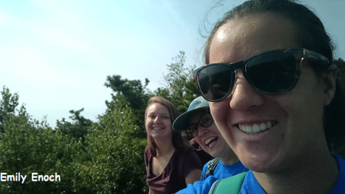
It was a beautiful Monday morning as my fellow Student Conservation Association Hudson Valley AmeriCorps members and I made the trek to the Sam’s Point Area of Minnewaska State Park Preserve. Members were coming from as far north as Moreau Lake State Park (near the Adirondacks) and as far south as Jones Beach State Park on Long Island.  I had come to Sam’s Point before to volunteer with bird surveys, so I was thrilled to return to this spot for our service project.  We had gathered at what would be our home base for the next three days – us in a circle, cars in the background, and a spectacular view of Sam’s Point itself.  We had gathered here for the 9/11 Patriots’ Day of Remembrance and held a moment of silence to reflect on that day 16 years ago, as well as the service we would be providing for the parks.

Before we could get started, some orientation was in order, as there was a lot of information to cover.  Sam’s Point has a rare population of ridgetop dwarf pitch pine barrens, supporting wildlife such as birds, fishers (small mammals related to weasels), and porcupines.  In April 2016, a wildfire broke out in the area, and efforts are underway to study the resilience of this ecosystem.  We were able to see more of the area by hiking up to the scenic overlook as well as to the super cool ice caves!

Invasive plant removal crew_EN
Some of the invasive species removal crew

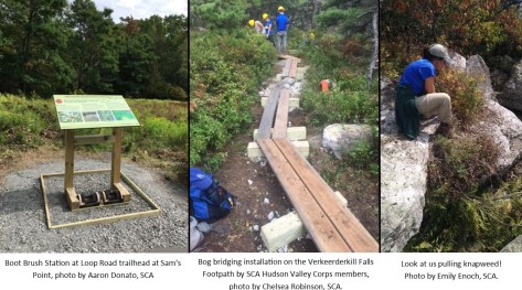
There were multiple projects being done in our three days of service.  Two crews worked on erosion control devices on the Verkeerderkill Falls Footpath. One crew worked on making water bars, trail structures that take the water off the trail. Another crew worked on building bog bridges, low wooden bridge structures that raise the trail out of the water or other sensitive area. The third crew was constructing invasive plant boot brush stations at various entrances around the park preserve.  I was part of the invasive species crew for the service project.  Our main focus was removing spotted knapweed, a purple flower that grew on the edge of the Loop Road. We had been out in the sun working hard on knapweed removal, and towards the end of the day, decided to move in the shade to work on stilt grass.

Invasives crew on the trail_EN
On the trail in Sam’s Point Area.


While pulling knapweed for many hours at a time, SCA members were able to have some fun.  We had started to play the game Murder on the Trail, which is where the “killer” would stick out their tongue at a person, and five minutes, later the “victim” had to die dramatically. Aaron (one of the program managers) came to check in on us and did not know we were playing this game –   he wasn’t sure what was happening when someone dropped to the ground.  Other fun things included exploring Lake Maratanza and finding baby snakes!  From the beginning of the trail at the bottom of the ridge, all the way to the top, past Sam’s Point towards Lake Maratanza, we pulled almost half a mile of knapweed. That’s a lot of knapweed!

The other teams worked hard and played hard too! The bog bridging crew installed over 170 feet of new bog bridges and the water bar crew improved almost a quarter mile of trail on one of the park preserve’s most popular trails. The boot brush crew installed three new boot brush stations to educate the public about invasive species and help stop the spread of invasive plant seeds.’

Three project photos

After three days of hard work and camping out at Sam’s Point, it was time for all of us to return to our homes in the Hudson valley.  We had done great work for the park and I was happy to be a part of it.

Thank you to the SCA, SCA members, State Parks, and the staff of Sam’s Point. Until next time!

Post by Emily Enoch, SCA Hudson Valley AmeriCorps Member

Light Your Way to a State Parks Lighthouse

From Lake Erie to Montauk Point, State Parks are home to seven historic lighthouses. Plan a trip to visit one of these lighthouses.

Lighthouse Montauk_0044a

President George Washington commissioned the building of the limestone Montauk Point Lighthouse in 1792 because of the dangerous shallow waters found off Long Island’s eastern South Shore; the lighthouse was completed in 1796.  Located in Montauk Point State Park, the Montauk Lighthouse continues to help provide safe navigation for ships sailing up and down the eastern seaboard and for ships arriving from across the Atlantic. It is the oldest lighthouse in New York and the fourth oldest lighthouse in the nation.

Stony Point -0075cp

The opening of the Erie Canal in 1825 saw a large increase in boat traffic on the Hudson River and the need for more aids to navigation along the Hudson River. Built in 1826, the lighthouse at Stony Point was the first lighthouse on the Hudson River. It was built by New York City resident Thomas Philips a point of land south of Bear Mountain in the Hudson Highlands.  For 100 years, the eight-sided, blue split stone lighthouse helped ships navigate the Hudson River before it was replaced by a steel tower in 1926.  Look for the lighthouse in Stony Point Battlefield State Historic Site.

2015-Tom Erhlandson

In the mid-1820s, as commerce increased along the Erie Canal and through the Great Lakes, so did the need for lighthouses on the Great Lakes.  Winds along the eastern shore of Lake Erie can be quite strong and boats needed safe harbors to protect them from these winds.  One safe harbor between Erie, Pennsylvania and Buffalo, New York was Portland Harbor (now known as Barcelona) in the town of Westfield. In 1828 the US Congress commissioned the Portland (Barcelona) Lighthouse to serve as a guide to Portland Harbor. The lighthouse was made of native fieldstone.  Completed in 1829 it was the first natural gas lighthouse in the country, using natural gas that was piped in by “wooden conductors from the fountain head, a distance of about a half a mile.”1 The lighthouse ran for 40 years until it was decommissioned in 1859.

HorseIsland_LighthouseFriends

The first lighthouse on Horse Island, outside the busy navy port at Sackets Harbor, was built in 1831 using the common practice of erecting the lighthouse on top of the keeper’s house.

John McNitt, the hero of the second battle of Sacket’s Harbor, served as the lighthouse keeper until 1841.  His nephew Samuel McNitt, who was also at the second battle of Sacket’s Harbor, served as lighthouse keeper from 1844 to 1860.  In 1870, a new brick lighthouse and keepers home was built, replacing the rundown 1831 building.  In 1899, the height of the lighthouse was raised from 45-1/2 fee to 55-1/2 feet to enable ships to see the light at a greater distance   The lighthouse was automated in 1926 and a metal tower automated light replaced the lighthouse in 1957.

_PRK4175

In 1847, the US Congress allocated $6,000 to build lighthouses on three islands in the St. Lawrence River to help ships navigate through the Thousand Islands.  One of those islands was Rock Island.  The brick lighthouse was first lit in 1848.  In 1894, the US Lighthouse Board (Lighthouse Board) raised the lighthouse five feet to increase the visibility of the light, which was being blocked by the lighthouse keeper’s house and trees on the island.  However, raising the lighthouse did not increase visibility, so the Lighthouse Board built a brick platform on the north side of the island and moved the lighthouse to the platform in 1903.  The light was decommissioned in 1958 after over 110 years of service. You can tour Rock Island Lighthouse State Park from mid-May to early October and you will need to take a boat to get there.

Golden Hil-637a4

Thirty Mile Point, or Golden Hill, is 30 miles east of the mouth of the Niagara River.  It is the northernmost point of land along New York’s of Lake Ontario shoreline.  Just offshore from 30 Mile Point, shifting sand bars make navigating these waters a challenge for ships passing by.  In 1872 the Lighthouse Board recommended that a lighthouse be built at 30 Mile Point and in 1873 US Congress authorized the purchasing of land and the construction of a lighthouse.  The limestone lighthouse was completed in 1876 and ran until 1958.  If you are looking for an out of the way place to stay, lighthouse keeper’s house is available to rent year-round.

OFNAD-a1

Fort Niagara, at the intersection of the Niagara River and Lake Ontario, was the site of the first lighthouse in the Great Lakes. The British Army built it in 1781 on top of the French Castle, the French trading post and fort built in 1727. The light was used to mark the mouth of the Niagara River, where cargo was offloaded and shipped overland to Lake Erie.  The lighthouse keeper did not live in the French Castle, his house was about a quarter mile away.

The opening of the Erie and Welland Canals in the 1820’s reduced ship traffic bound for the Niagara River.  In April 1855, a tornado damaged buildings at the fort. The damages were repaired later that year.  Despite the repairs, the French Castle fell into disrepair in the middle to late 1860’s.  In 1868, the Lighthouse Board reported that:

“the wooden tower stands in the old block-house now used for officers’ quarters, and is so old and out of repair as to let in the snow and rain in stormy weather. Last winter the roof of the building took fire from a spark from one of the four chimneys which surround the tower. The danger of having the valuable lens destroyed by an accident of this kind, and the inconvenience of using the stairway and passages of the officers’ quarters as a thoroughfare for the supply of the light, make it expedient to erect a new tower, (the old one not being worth repairing,) in a safer and more convenient position.  The floors and plastering of the keeper’s dwelling and the fences require repair. The barn is in a ruinous state, and should be removed or rebuilt.”

US Congress appropriated $16,000 in 1871 for a new lighthouse at Fort Niagara. Because the Lighthouse Board could not find a good location for the lighthouse in the fort, the limestone lighthouse was built next to the lighthouse keepers house along the eastern bank of the Niagara River.

The lighthouse was replaced by a light on a nearby radio tower in 1993 and the light was decommissioned the same year.

Occasionally, staff from Old Fort Niagara State Historic Site lead programs and events in the lighthouse.

1 New-York evening post., July 14, 1830, Page 2

Lighthouses

Sources and additional reading

Historic Lighthouses and Light Stations in New York

Important Dates in United States Lighthouse History

Lighthouse Friends

Marinas.com Lighthouses of New York, aerial views of Montauk Point, Rock Island, Stony Point, and Thirty-Mile Point Lighthouses

The Schenectady cabinet., February 15, 1826, Page 2

University of North Carolina, Lighthouses of the United States: Downstate New York

University of North Carolina, Lighthouses of the United States: Upstate New York

US Lighthouses, information on Barcelona, Fort Niagara, Montauk Point, Rock Island, and Thirty-Mile Point lighthouses.

Iroquois White Corn Project

Ganondagan State Historic Site, in the Finger Lakes Region, was once the capital of the Seneca Nation and home to as many as 4,500 people. Ganondagan is translated to mean “a town on a hill surrounded by the substance of white” referring to white blossoms growing there which turned into an edible fruit.   Located in Victor, New York, Ganondagan is the only New York state historic site dedicated to Native American history.

The original Ganondagan (ga·NON·da·gan) community was destroyed by a campaign of the French in 1687.  At the time the French army and their allies spent days destroying corn, beans, squash and other foods that sustained the Seneca Nation and other Haudenosaunee (Iroquois people).  Records show that that over 1,200,000 bushels of corn were cut down, burned and destroyed in mid-July of 1687. Seneca homes were also burned to the ground.  In 1987 Ganondagan State Historic Site opened as a New York State historic site 300 years after its demise.

The Iroquois White Corn Project (IWCP) was first established in 1997 by Dr. John Mohawk, on a Seneca reservation known as Cattaraugus, upon his death in 2006 the project became dormant.

In 2012 the Friends of Ganondagan re-established IWCP in a farm house on site with the help of Historic Site Manager Pete Jemison who moved the equipment and Iroquois White Corn Project Ganondagan.  Today the IWCP produces three products from heirloom Iroquois White Corn: whole hulled dried corn, roasted white corn flour, and white corn flour, which are marketed by the Friends group. Iroquois White Corn is a slow food, gluten free and highly nutritious, especially when combined with beans.

The process of removing the hulls from the kernels using cooking lime is known as nixtamalization.  This culinary technique softens the corn hulls and kernels, creating whole hominy which can be ground in to masa flour.  Nixtamalized corn has healthy amino acids and vitamin B and is more flavorful and aromatic. Nixtamal is the Spanish interpretation of the Aztec term for the process of soaking dry corn in fire ashes to improve flavor and nutrition nixtamalli.

About 75% of our corn is obtained from Haudenosaunee farmers and products are sold to the Seneca Nation, Oneida Nation, retail outlets (including Wegmans) and through the gift shop in the Seneca Art & Culture Center.

The Iroquois White Corn Project provides employment and training for both Native American and non- Native youth. Volunteers assist the IWCP at the annual husking bee (held in the fall) and by sorting corn kernels.  Volunteers also assist in maintaining our onsite gardens.  We grow the three sisters – corn, beans, and squash – known to the Seneca as Our Sustainers – Dioheko.

The Seneca Art & Culture Center at Ganondagan opened in October 2015 and houses a gallery, two classrooms, an orientation theater, auditorium, caterer’s kitchen, archival storage, and offices for the staff.

More information about Ganondagan and special events sponsored by the Friends can be found at Ganondagan.org

Post by Peter Jemison, State Parks

A Conservation Cornerstone Celebrates 20 Years

This year, the New York State Bird Conservation Area (BCA) Program celebrates its 20th anniversary. Since 1997, the BCA Program has been promoting the conservation of birds and their habitats on designated state-owned lands and waters in New York State. There is no other program like it in the United States. The BCA Program is modeled after Audubon’s Important Bird Area (IBA) Program but is backed by legislation.  Sites are considered for BCA designation if they meet criteria relating to high concentrations of birds, bird diversity, or the presence of at-risk species. Recognizing a site as a BCA brings awareness to the needs of birds on state-owned lands and encourages management that benefits the bird populations. While the BCA Program focuses on birds, the program also benefits other species that share the same habitats.

Cerulean Warbler.
A rare cerulean warbler, photo by Charlie Trampani.

Audubon has partnered with the New York State Office of Parks, Recreation and Historic Preservation (State Parks) on the BCA Program since its beginning, and has held up the BCA Program as a model for other states to protect birds. This fall, Audubon was delighted to join State Parks in celebrating the 20th Anniversary of the program, in conjunction with the designation of the 60th BCA in Ganondagan State Park.

Ganondagan photo
Dedication of the Bird Conservation Area at Ganondagan State Historic Site, photo by Laura McCarthy, Audubon NY.

In recent years, Audubon’s partnership with State Parks has expanded to include Audubon in the Parks initiative, which is a partnership with Audubon New York, State Parks and its Regional Commissions, Audubon Chapters, and friends groups to advance bird conservation in State Parks, specifically focusing on BCAs and IBAs. Through Audubon in the Parks, Audubon assists with the implementation of BCA management recommendations, conducts bird monitoring, and helps with other strategies and research activities that benefit priority birds and habitats. In addition, Audubon advocates for funds to ensure that habitats are preserved and managed in a way that benefits priority birds and further connect people to these unique places.

BirdersFilmoreGlenStatePark_JillianLiner
Audubon New York staff and members bird watching in Fillmore Glen State Park, photo by Jillian Liner, Audubon NY.

Through Audubon in the Parks, Audubon has been active in more than 50 State Parks across the state, including 20 BCAs. This successful initiative continues to grow through projects like the one recently completed at Schodack Island State Park, which has been designated as a BCA because of nesting Cerulean Warblers and wintering Bald Eagles. Led by the Audubon Society of the Capital Region, this BCA project included building bird blinds for visitors to view birds without disturbing them and removing invasive species within the park. The chapter continues to foster a community connection to the park and importance of this BCA by hosting eagle walks and other events such as the recent Schodack Island Raptor Fest.

Birdblind AIP ASCR
Members of Audubon Society of the Capital District constructing a bird blind at Schodack Island State Park, photo by Laura McCarthy, Audubon NY

Audubon congratulates New York State on the BCA program and looks forward to continuing the strong partnership with State Parks to make New York a better place for birds and people.

More about BCA’s

Map of Bird Conservation Areas

Post by: Jillian Liner, Director of Bird Conservation, Audubon New York

The Niagara Gorge at Low Water

When autumn arrives, what comes to your mind first? Many say the changing foliage or enjoying a hike along a trail, savoring those crisp days given to us during this time of year.

However, here in the Niagara Region of New York, autumn holds an annual event that is well-worth a journey down into the Niagara Gorge! It is the time of year when in addition to viewing the raging rapids, you can also see the river at low water. This is all made possible because of additional water being diverted  for the New York Power Authority and the Ontario Power Company to produce hydroelectricity.

Regulated under The Boundary Waters Treaty of 1909 (revised in 1950), the US and Canada are allowed to divert water for the purpose of power generation as long as they agree to preserve the scenic beauty of the Falls and the Niagara River. Thus, the erosion rate of the falls is reduced significantly. The cliff face is more stable and it makes it easier to maintain the viewing areas at Niagara Falls State Park.

Summer Flow occurs from April 1 until October 31, with 50% of the river water diverted above the Falls during the day and 75% diverted during evening hours to produce electricity.

Photo by Nicole Czarnecki

Winter Flow occurs from November 1-March 31, when 75% of the water above the Falls is diverted, thus we get to see only a quarter of the water flow over the falls.

Gorge at Low Water

This offers opportunities to explore part of the exposed Whirlpool Sandstone rock layer in the Niagara Gorge during the winter flow. The Whirlpool Sandstone layer is underwater during the summer flow.

NIA gorge low water

There are guided hikes available with the Niagara Region Park Programs Office in November; in 2017 they are Saturday, November 11 & Saturday, November 18. The hike will take you beyond the Whirlpool to the site of the rapids viewing area. At one time, the exposed rocks were a scenic stop for the Great Gorge Route, an electric trolley line that ran from 1895-1935, running from Niagara Falls to Lewiston, NY. The route also journeyed over to Canada (1899-1932) on what was known as the Niagara Belt Line.

Great Gorge Viewing

At this trolley stop, passengers were able to walk down the stairs to better view the incredible “giant wave” as seen in the historic postcard below.

Giant Wave Postcard

Post by Carol Rogers, State Parks.

Featured image:  Niagara River Backdrift, accessed from Wikicommons

The official blog for the New York State Office of Parks, Recreation & Historic Preservation