

Spanning Chautauqua, Cattaraugus and Allegany counties at New York’s wild southwestern border with Pennsylvania, this region contains the largest State Park – the 65,000-acre Allegany State Park.
The region also has a dramatic shoreline along Lake Erie that contains a historic lighthouse and is important habitat for many migratory waterfowl. This area is a wonderful place to experience dramatic sunsets over the lake.
Any successful hike starts with a good map. Maps for hiking trails and a variety of other useful information on State Parks, including those in the Allegany region and other regions, are now available on the NYS Parks Explorer app. The free app, which is available for use on Android and iOS devices, is easy to download, user friendly and allows patrons to have park information readily available.
Trail maps are also available on each individual park website page at parks.ny.gov and at the main office of each park. Links to maps are also included in the trail descriptions in this post. Be sure to download maps ahead of time or carry a paper copy as a back up
As with all hikes, there are a few things to remember beyond carrying a mobile phone. Check the weather forecast before you go, and dress appropriately. Wear sturdy, yet comfortable shoes or boots, bring enough water and snacks, and perhaps carry a camera to capture what you see. Be aware of your surroundings and mindful of hikes on steep terrain or those that go near cliff tops. Having a small first-aid kit available in case of an emergency is never a bad idea.
Hiking poles are also useful and can transfer some of the stress of hiking from your knees and legs to your arms and back.
Hikers should plan their route in advance, know how long a trail is and how long it ought to take to finish. If weather conditions change for the worse, be prepared to turn back. Don’t let “summit fever” (a desire to reach a specific destination) make you press on. Since daylight is not an unlimited resource, even in spring and summer when days are longer, tossing a flashlight or headlamp into your backpack is a good form of insurance, should you unexpectedly find yourself on the trail as dusk approaches.
State Park facilities are carry-in, carry-out, so don’t leave trash behind. Follow Leave No Trace principles to keep trails clean for everyone.
Additionally, as incidents of tick-borne diseases surge in the state, it is always important to check yourself for ticks after being outside, even if it is only time spent in your own backyard.
Lastly, as the COVID-19 pandemic continues, remember to practice safe social distancing, particularly in parking lots and at trailheads, and use face coverings when a distance of six feet cannot be maintained, even if you have been vaccinated. To learn more about important COVID safety guidelines, CLICK HERE.
Cattaraugus County
Allegany State Park, 2373 ASP Route 1, Salamanca, NY (716) 354-9101: This 65,000-acre park offers an outdoor paradise with forests, mountains, meadows, amazing rock formations, three lakes and numerous streams and ponds. The park’s two developed areas – Red House and Quaker – have more than 90 miles of hiking trails and naturalist walks. Here are some staff picks.
Located on the park’s Quaker side, the Blacksnake Mountain Trail is one of the oldest trails in the park with a unique history. Parts of the trail follow the 1888 section of A&K Railroad (Allegheny & Kinzua), which is evident in the gentle slope on the north side of the three-mile loop. In 1933, the professors of the Allegany School of Natural History (located near Science Lake) mapped out a hiking trail they officially named the “Nature Hiking Trail” to conduct their field studies with their students. It was later renamed “Blacksnake Mountain Hiking Trail” in 1980 after Governor Blacksnake, an Iroquois Indian chief for the Seneca Nation of Indians, who allied with the United States in the War of 1812.
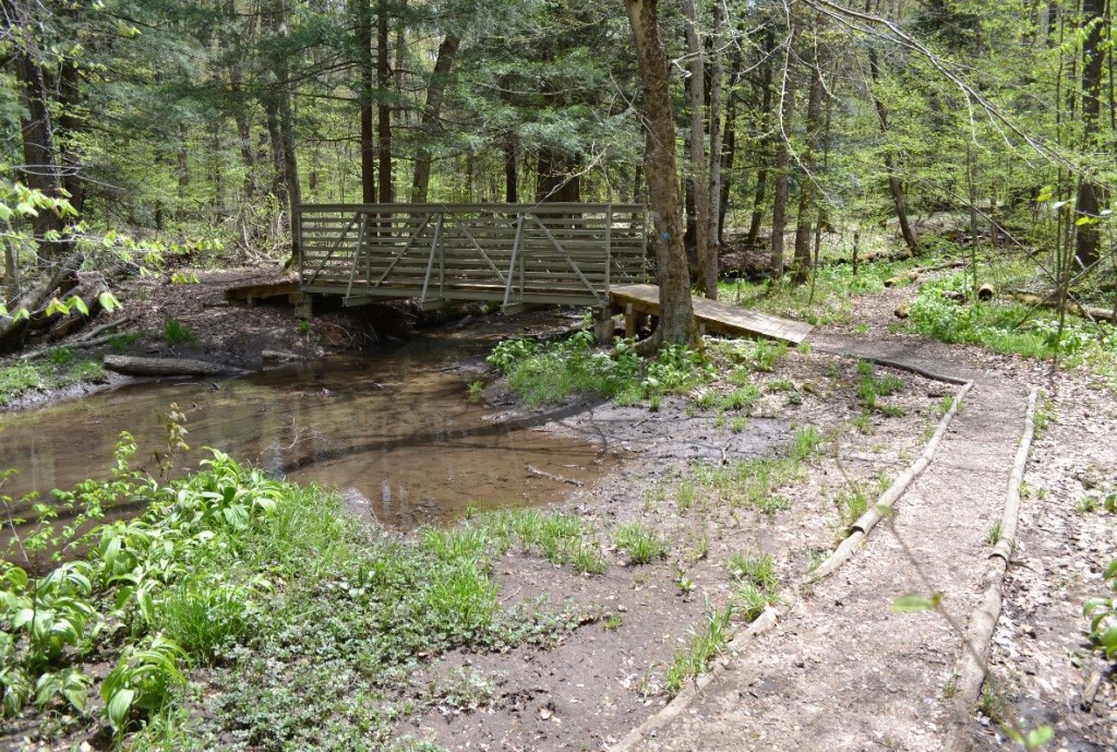
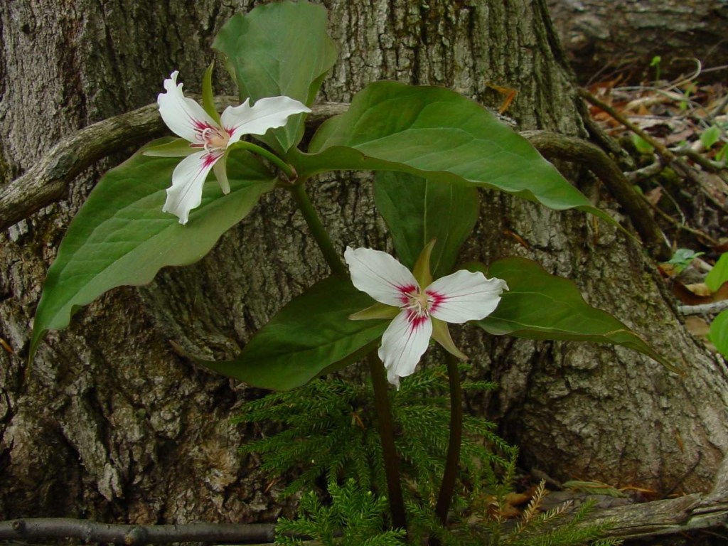
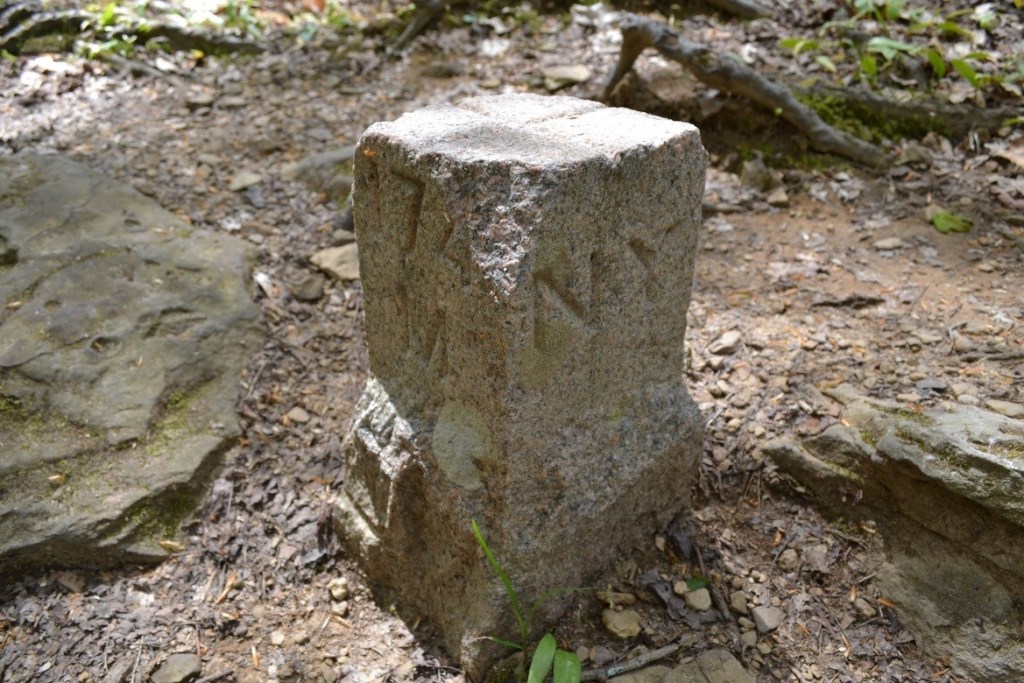
The trail crosses several streams with new bridges, and a short steep climb leads to mature black cherry trees estimated to be between 100 and 130 years old. Cucumber magnolia, tulip trees and hemlock are other trees of interest along the way. This is a favorite trail for spring wildflower lovers. Trillium, Dutchmen’s breeches, squirrel corn, and spring beauties are just a few of the ephemerals that announce the changing of the seasons. Near the top of the trail, look for a granite milestone marker which represents the border of New York and Pennsylvania, where you can put a foot in each state.
In this slideshow, start with the old railroad grade, then see the new bridge at Murray Brook, a painted trillium and the granite marker marking the New York/Pennsylvania border.

Bear Paw Hiking Trail is named after a style of snowshoe used by Native Americans and was originally designed as an interpretive snowshoe trail in 2015 by park naturalists. The 2.4-mile trail starts at the rear of the Summit Area parking lot. Look for brown numbered markers which highlight unique flora such as ground cedar, various hardwoods, and lowbush blueberries. Halfway along Bear Paw, at the end of the loop, hikers will be treated to the masterfully built Stone Tower, an Allegany State Park landmark, constructed by the Civilian Conservation Corps in 1934. The tower offers beautiful views of large open valleys, the city of Salamanca and Red House Lake.
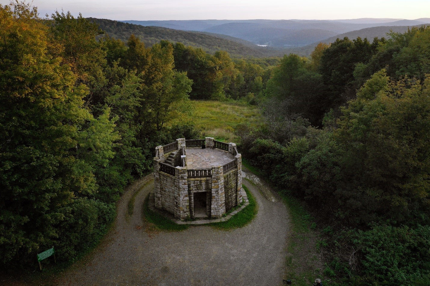

The second half of the trail traverses the south side of the ridge, through beech and maple forests and into a meadow. Depending on the time of the year, hikers may get to sample low bush blueberries or wintergreen growing in this area. The last section has a short, steep incline that adds a bit of challenge. Bear Paw ends at the Summit Warming hut.
Find a map of this trail here.


The 5.2-mile Robert C. Hoag Bicycle Path is named after the former Seneca Nation President and was dedicated in June 1990. Starting at the Red House entrance of the park, the path passes old apple trees and large stands of spruce and Scotch pine, along with many varieties of hardwoods, shrubs and wildflowers. The most used part of the path is around Red House Lake, where a 3.4-mile trail offers the potential to spot such wildlife as beaver, muskrat, great blue heron, and many species of waterfowl. Spurs off the trail lead to the Red House Wetland Interpretive Complex, Beehunter Cabin Trail and Camp Allegany. Several benches are located along the way to relax and enjoy the surrounding beauty.


Work on the new Quaker Multi Use Trail began in the summer of 2020 between the Taft cabin and the Quaker General Store. The second phase will start this season, and will continue the trail Quaker Lake Beach. Once complete, the trail will offer five miles of accessible paths winding though woodlands and fields along ASP Route 3 and Quaker Lake, including several scenic crossings of Quaker Run.


Find maps to Allegany State Park here and here.
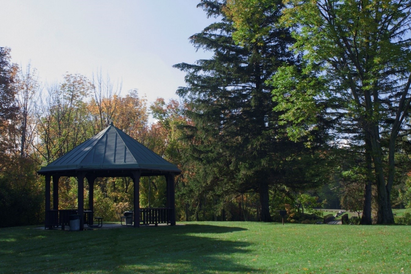
Pat McGee Trail, Little Valley, (716) 354-9101: The recently-acquired 12.1-mile Pat McGee Trail connects the city of Salamanca and village of Cattaraugus. This multi-use trail along a former rail bed has connections with the current Finger Lakes Trail System, which has about 1,000 miles of trails in southern and western New York, and the truly sprawling North Country Scenic Trail, which in turn provide links to Allegany State Park and the Allegany National Forest in Pennsylvania. Named for former state Sen. Pat McGee, the trail opened in 2005 and is used for bicycling, hiking, snowmobiling, and horseback riding. It features a 1.8-acre community park with pavilion and two gazebos in Little Valley, along with five trailheads with parking areas. It also contains six former rail bridges that were rehabilitated for trail use.
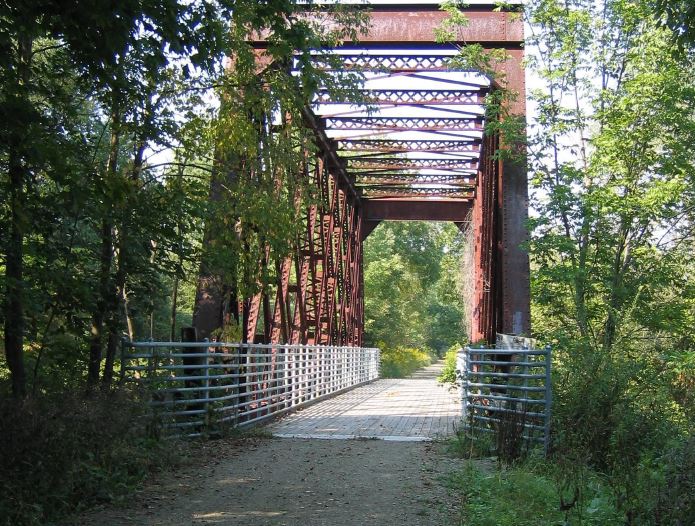
Find a map here.
Chautauqua County
Long Point State Park, 4459 Route 430, Bemus Point, (716) 386-2722: A one-mile loop, the multi-use Minturn Trail leads to the point of a peninsula that extends into Lake Chautauqua. Some of the sites along the trail include the house foundation of the former Minturn Mansion, wildlife viewing areas and various fishing access points. The marina area at the end of the trail features a boat launch and spaces to sit by the lake. The trail is a popular place for many different activities including hiking, fishing, birdwatching, mountain biking, and cross-country skiing.
Find a trail map here.


Lake Erie State Park, 5838 NY-5, Brocton, (716) 792-9214: Hike the East Trail and from the bluffs explore sights of the shallowest Great Lake. This wide trail is great for families and beginner hikers featuring breathtaking sights of Lake Erie and a vernal pool tucked along the wooded path. This multiuse trail is commonly shared with disk golfers and migratory bird watchers. Wildlife commonly seen at Lake Erie State Park includes the common tern, red headed woodpecker, black squirrel, deer and bald eagle.

Find a trail map here.
Cover shot- Red House Lake at Allegany State Park. All photos by NYS Parks.
Get Out and Explore Other Regions in New York State Parks
The “Get Out and Explore” series outlines staff-recommended hikes in other regions of New York, including Genesee, Finger Lakes, Central, Palisades, Taconic, Saratoga/Capital and Thousand Islands.
