Here in the Finger Lakes, one of the best ways to access the natural beauty of the area is by taking a hike on one of the many trails that can be found within the region’s state parks. The trails (in parks such as Watkins Glen, Taughannock Falls, Robert H. Treman, and Fillmore Glen) lead hikers through a variety of environments, including mature forests, meadows, lake shores, and wetlands. Of course, hikers can also enjoy the deep gorges, dramatic cascades, and waterfalls the region is famous for! Over the years, hiking has gained popularity nationwide. With thousands of miles of hiking trails, New York State has a lot to offer people looking to get outside. The Finger Lakes region of the State Park system sees several hundred thousand visitors each year, many of whom come to hike the trails. Foot traffic, weather, and time have left some of the trails in Finger Lakes state parks eroded and in need of repair. This erosion not only makes the hiking experience less enjoyable for trail users, it also leads to negative impacts on the surrounding ecosystems. To meet this problem head-on, the Finger Lakes Regional Trail Crew (FLRTC) was developed in the spring of 2017.
Some of the hard-working members of the Finger Lakes Regional Trail Crew, photo by State Parks
The main goal of the trail crew is to maintain safe and enjoyable hiking trails for park visitors, while protecting the natural and historic resources of the park. Currently the FLRTC consists of three Parks staff members and a diverse group of local volunteers. The Excelsior Conservation Corps (an AmeriCorps program) also helps out with specific projects. In 2018, the trails crew will host two interns from the Student Conservation Association (SCA) Parks Corps devoted to trail stewardship. This team effort has led to a tremendous amount of progress towards the Finger Lakes Park’s trail improvement goals.
Boardwalks protect wet areas or fragile habitat and make for easier walking for visitors, photo by State Parks.
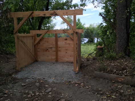
Trail work, as a rule, takes a large amount of physical effort and creative problem solving. The work done by the FLRTC is no exception. Traditional tools and building techniques are often employed. Many of the trails in need of repair are in areas that are not accessible by vehicles or equipment. As a result, many of the materials used in trail construction have to be carried in by hand; it takes a strong crew to lug in lumber, stone, and gravel. Sometimes materials have to be moved down into or across the area’s gorges. The trail crew uses high-strength zip lines to accomplish this task. This is the safest method and protects the fragile slopes and vegetation.
Boardwalks protect wet areas or fragile habitat and make for easier walking for visitors, photo by State Parks.
All of this hard work pays off in the form of functional, safe and visually pleasing staircases, boardwalks, and bridges that blend with the surroundings.
As you get out on the trails this year, take a minute to look down from the beautiful scenery. The trail you are on most likely took a lot of hard work to build and maintain – but chances are the park staff and volunteers behind the work loved every minute of it!
Imitation is the sincerest form of flattery. And back in early 2016, Schodack Island State Park Manager John Lowe was musing with Capital Region Audubon Society President John Loz about potential partnership projects. Moreau Lake State Park’s nifty bird blind initiative came immediately to mind.
Designated both a state Bird Conservation Area (BCA) and an Audubon Important Bird Area (IBA), Schodack Island is a bird-watchers mecca waiting to happen. Many birds of conservation concern – bald eagles, great blue herons, cerulean warblers, to name only a few – nest on site. The waterfowl assemblages are impressive. But, aside from two interpretive signs near the parking lot, the Park offered limited amenities or functional improvements to engage the public with its remarkable wildlife resource. As the poet Gertrude Stein might have said, there was “no there there.”
But it takes a village, and in fall 2016, Park Manager Lowe cobbled together a motley assortment of local Audubon operatives, Schodack “friends”, along with community members and rank volunteers to work alongside his very capable Park Operations professionals in constructing three bird watching blinds at strategic spots along the trails at Schodack Island State Park.
Bird blind in progress, note the nice view of the river beyond the blind. Photo by Audubon Society of the Capital District.
To be honest, the 6’ x 8’ wooden blinds were something that Park Manager Lowe’s handy Park Operations staff could have hammered together themselves in one day, and “done it good”. Lowe wisely summoned the butcher, the baker and the candlestick maker to make sure to give the community real ownership in his initiative. It worked!
Schodack Island State Park’s bird blinds serve several critical customer service needs: the rich viewsheds framed by intelligent placement of the blinds within the Park’s varied landscape draw serious photographers and bird-watchers, casual visitors can enjoy “close encounters of the bird kind” without disturbing wildlife, and also benefit from helpful interpretive signage in each blind.
Visitors are encouraged to enter their own bird sightings in the shelter register to help build the park’s developing scientific record. And the many joggers, dog-walkers and hikers who frequent the trails daily will welcome these arresting destinations within the park’s long and rather placeless linear trail system, 13 miles total with few rewards. So now, there’s a “there” there!
Realizing the park’s tremendous potential for developing bird tourism, Park Manager Lowe has been working closely with the Friends of Schodack Island State Park and the Audubon Society of the Capital Region to articulate a long-range vision which maximizes both the public accessibility to and the protection of the Park’s extraordinary avifauna, including planning to embark on a fourth bird-watching blind this spring.
The Audubon Society of the Capital Region mustered three more volunteer crews in spring 2017 to help stain the bird blind exteriors. And in summer 2017, the Audubon Society won a grant to oversee the design, fabrication, and installation of informative interpretive panels for each of the blinds. You might call it a model collaborative project. Or just a diligent Park Manager making sure that all the players get in game.
Under the leadership of former State Parks Deputy Commissioner Al Caccese, Audubon New York, the state-wide affiliate of the National Audubon Society, began an outreach initiative in 2009 which Al lovingly dubbed “Audubon in the Parks” to advance bird conservation in New York’s State Parks. At the time, Al was the Executive Director of Audubon New York, so the partnership made perfect sense. Through its 27 local chapters, Audubon New York has provided a wide variety of programs and services at over 50 state park facilities throughout New York, particularly targeting those designated as BCAs or IBAs.
For example, the Audubon Society of the Capital Region, Audubon New York’s Albany affiliate, has waged war with invasives, sponsored lectures, set up bluebird boxes, conducted bird walks and/or participated at festivals at every state park or historic site within its purview: Schoharie Crossing, Thacher and Thompsons Lake, Schodack Island, Peebles Island, Saratoga Spa and Grafton Lakes. The Audubon in the Parks partnership has done much to advance the mission and goals of State Parks, while forwarding the Audubon agenda.
We thank the butcher, the baker and the candlestick maker.
An example of the excellent craftsmanship that went into the building of the bird blinds, photo by Audubon Society of the Capital District.
In 2012, one of the largest weather events in New York’s recorded history swept across the state’s southeastern border. Superstorm Sandy’s wrath bore down as counties upstate and on Long Island were still recovering from the devastating flood waters and wind damage brought by Hurricane Irene and Tropical Storm Lee in late summer 2011. Fourteen counties were declared federal disaster areas, thousands of lives were affected, countless miles of roads closed or washed out, and hundreds of thousands of homes damaged or destroyed by storm surge and catastrophic flooding. However, in typical New York style, once the storm subsided, people from across the state came together to begin the recovery effort.
Five years after the storms, the state is continuing to invest funds in order to ensure that New York is more resilient and better prepared to withstand future storm impacts. Although most of the attention has understandably focused on housing reconstruction and high-profile infrastructure proposals, there is a quieter, but no less critical story to be told, about our State Parks. Led by the tireless efforts of Governor Andrew Cuomo, state government has worked closely with local governments and community organizations to make the state park system more resilient than ever.
According to a recent report by the Governor’s Office of Storm Recovery (GOSR), the state has received over $4 billion in Community Development Block Grants for disaster recovery (CDBG-DR) from the United States Department of Housing and Urban Development (HUD). The CDBG-DR program was implemented by HUD in the 1970s to promote long-term recovery efforts in communities affected by disasters. Through this program, managed by GOSR, approximately $111 million of these funds have been invested toward resiliency improvements at four State Park facilities – Robert Moses, Jones Beach and Hempstead Lake State Parks on Long Island, and Roberto Clemente State Park in the Bronx.
One of the jewels of the state park system, Jones Beach State Park on Long Island’s south shore welcomes nearly six million visitors to swim, sunbathe, recreate and relax at its white sandy beaches every year. Less than 20 miles from New York City, the park is a vital public resource for the millions of residents and visitors in the community. During Sandy, the park suffered significant damage to its buildings and infrastructure. Thanks to $4 million in grant funding from GOSR, State Parks will be able to upgrade the park’s drainage infrastructure to slow down and filter stormwater runoff and help improve water quality at the popular Zach’s Bay swimming area. The project also includes funding to install flood resistant doors and windows on select buildings with critical infrastructure. Further, by incorporating native plantings and continuing to conserve the large natural areas in the park, the landscape can better buffer the impacts of storms on facilities in the park and around the bay.
Volunteers plant beach grass at Jones Beach State Park.
Robert Moses State Park, located on the western end of Fire Island, is best known for its five miles of public beaches which receive over four million visitors a year. The beaches and dunes on barrier islands, like those at Jones Beach or Robert Moses, serve as a crucial buffer between the open ocean and the coastal towns, helping to reduce the damaging effects that can occur during storm events. The natural habitats, animals, and plants of these places are adapted to the changing shoreline and the movement of sand, but roads and homes are not. During Sandy, Robert Moses State Park experienced severe erosion of its beaches from wind, waves, and heavy surf. Though nature would likely restore these beaches over time, there was high risk of damage to roads and buildings in the park. Grant funds through the CDBG-DR program helped stabilize these vulnerable areas of the park by nourishing those sections of beaches to return them to their pre-storm conditions. Additional CDBG-DR funding will also go toward replacing the park’s existing water treatment plant with a newer, more flood-resistant facility elevated above the current flood zone.
Improvements are also underway at Roberto Clemente State Park in the Bronx, which spans 25 acres along the Harlem River in the Morris Heights neighborhood. The park provides recreational facilities for underserved communities in the region in addition to serving as a coastal barrier for residents and local infrastructure, including the nearby River Park Towers residential complex and an adjacent Metro North station. During Sandy, floodwaters rose to more than three feet above the park’s 40-year-old bulkhead, damaging the park’s lower plaza and esplanade. CDBG-DR funds will be used to give this critical neighborhood gathering place a much-needed makeover. The outdated bulkhead will be replaced, and the esplanade will be rebuilt with modern infrastructure elements and green design (including landscaping with plants native to this area). These efforts will create a more stable, resilient shoreline and park facility.
Improvements to Hempstead Lake State Park, image courtesy of Stantec
Finally, plans are under development to invest $35 million in CDBG-DR funds at Hempstead Lake State Park on Long Island, as part of the larger $125 million Living with the Bay project. The Living with the Bay project aims to connect communities along Nassau County’s Mill River watershed and strategically install protective measures to help mitigate flooding, improve water quality, and enhance the overall ecology from Hempstead Lake State Park to the South Shore Estuary. As part of the overall project, major improvements will be made to the park, including rehabilitating a century-old dam and non-functional control systems, renovating multi-use trails, constructing fishing piers and boat launches, dredging park ponds (to increase water storage capacity during flood events), and constructing a “floatables catcher” to help capture trash that flows into the park during heavy rain events. A multi-purpose educational facility will also be constructed and will serve as a coordination center during emergencies.
Installing wetlands project
Constructing river rock dams to control water flow
Constructing a “floatables collectors’
Storms are a natural and often necessary part of maintaining our coastal ecosystems, but can be devastating to our homes, our communities, and businesses. Although New York has made tremendous progress recovering from the damages suffered during Superstorm Sandy, Hurricane Irene, and Tropical Storm Lee, there is still more work to be done. Governor Cuomo, recognizing the value of our parks to the state’s economy and to the health and well-being of its residents, has helped marshal the resources the agency needs for both immediate rebuilding and more strategic long-term recovery efforts. New York will continue to invest in its state parks to help us continue to become more resilient and able to meet the challenges yet to come.
Post by Ben Mattison, Excelsior Fellow, State Parks
Have you heard about wildfire outbreaks in California or New York on the news? Do you know how a prescribed burn and wildfire differ from one another? A prescribed burn is very different from a wildfire. Prescribed burning is a management tool that is precisely planned for safety and meeting set goals, while wildfires often occur unpredictably and without warning. State Parks utilizes prescribed burning for both public safety and conservation purposes. This past spring, at the Ganondagan State Historic Site near Rochester, prescribed burning was used for both conservation and to replicate traditions of the Seneca people.
Control lines are created at the edge of the area to be burned so that the fire does not escape designated areas. These lines are approximately 12 feet wide and are kept wet and clear of fire by prescribed burn staff, photo by Joel Carlson of Northeast Forest & Fire Management LLC.
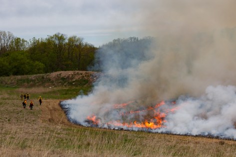
Ganondagan State Historic Site (Ganondagan) celebrates and interprets the lives and culture of the Seneca people, specifically the Seneca that lived on site between 1655-1687. The site is 570 acres, and in 2009, a 70-acre portion was set aside for grassland management. Journal entries from European visitors during the time of Seneca occupation, described the areas surrounding Ganondagan. In 1669, explorers Galineē and Dollier described vast oak openings with sparse, but lofty, oak trees and grasses taller than a man that extended for hundreds of miles in every direction.¹ These observations paint a picture of warm season grasslands, with grasses reaching heights of 8 feet or taller, sparse wildflowers and oak trees around their fringe.² Warm season grasses begin growing in June, reaching full maturity by August or September. Some of the earliest observations indicate that the Seneca people burned these grasslands annually, managing them to attract game animals and birds, and to facilitate nut collection.³
Prescribed fire at Ganondagan was lit with drip torches, photo by Joel Carlson of Northeast Forest & Fire Management LLC.
The 70 acres set aside for grassland management began its transformation in 2009, with the goal of recreating the landscape that existed for the Seneca at Ganondagan almost 400 years ago. A fully established warm season grassland can support many forms of life, and at Ganondagan it is a haven for rare grassland bird species. Grasslands are ecosystems maintained by natural disturbances like fire. Without disturbance, a grassland will gradually go through the steps of succession to become a shrubland and later a forest.
Before the prescribed burn at Ganondagan in May 2017, the grasslands had begun to build up a thick thatch layer, decreasing both the amount of sunlight reaching its sun-loving plants and the amount of bare ground between plants (which grassland birds and mammals like for habitat).
A successful prescribed burn is designed to keep the fire within control lines and the smoke up and away from people and homes, photo by Joel Carlson of Northeast Forest & Fire Management LLC.
Time of year can play an important role in how an ecosystem reacts to a burn. At Ganondagan, a spring burn was chosen to cut off early growth of invasive species and to promote the growth of the warm season grasses like big bluestem and Indian grass. Future prescribed burning done on the site may happen in different seasons depending on the desired outcome. For example, a prescribed burn taking place in this warm season grassland in the fall would promote the growth of forbs (broad leaved plants), such as wildflowers. Regardless of the timing, a properly done prescribed burn will not completely remove grasses or forbs, but can help achieve the best plant composition for grassland birds.
Prescribed burning was the perfect way to manage the grasslands at Ganondagan: it created a disturbance to maintain the ecosystem, returned carbon and nitrogen to the soil in the form of ash, and opened the grassland to more sunlight. This burn also provides a unique opportunity for educators to interpret this management tool, once used by the Seneca at Ganondagan to maintain the grasslands in the 17th Century, and now updated for the 21st century!
The ‘mop up’ of a prescribed burn ensures that all of the fire is completely out and, as in the case of the Ganondagan Prescribed Burn, can take longer than the burn itself, photo by Joel Carlson of Northeast Forest & Fire Management LLC.
This valuable management tool will continue to be used at the Ganondagan State Historic Site and are exploring future opportunities.
Post by Whitney Carleton-DeGeorge and Michael Galban , State Parks
Featured image: Joel Carlson of Northeast Forest & Fire Management LLC.
1 Galinée, René de Bréhant de. (env. 1670) 1903. “Le Voyage De MM. Dollier et Galinée.” In Exploration of the Great Lakes 1669-1670 by Dollier de Casson and de Bréhant de Galinée, ed. James H. Coyne. Toronto: Ontario Historical Society Papers and Records.
² Parker, Arthur – New York State Archeologist – “The League of the Five Nations – a Story of the Aboriginal Empire State” published in Livingston County Historical Society 34th Annual Meeting, Geneseo, NY, 1910.
³Donck, Adriaen van der, 1620-1655. (Beschryvinge van Nieuvv-Nederlant. English) A description of New Netherland / Adriaen van der Donck; edited by Charles T. Gehring and William A Starna; translated by Diederik Willem Goedhuys; foreword by Russell Shorto.
In October 2012, Superstorm Sandy hit New York, causing severe damage on the Atlantic and Long Island coasts. The strength of the storm highlighted the importance of storm readiness. In one park on Long Island, the storm also brought an opportunity for habitat restoration.
Sunken Meadow State Park is located on the north shore of Long Island, and contains the Sunken Meadow Creek, which flows into the Long Island Sound. The park is over 1,000 acres and includes important coastal habitats including coastal forest, low salt marsh, marine eelgrass, tidal creek, and maritime dunes.
When Sandy struck, it destroyed a berm (a wall made of earth) that State Parks constructed in the 1950s. Ever since it was built, the culverts through the berm were inadequate and greatly reduced tidal flow to Sunken Meadow Creek, decreasing the quality of the habitat upstream. Rather than rebuild the berm, a plan was set in motion to restore the tidal marshland by replacing the berm with a bridge and planting saltmarsh species.
The remnants of the berm in Sunken Meadow Creek after its destruction by Superstorm Sandy in 2012.
Even before Sandy struck, many partners had joined with State Parks to restore the habitat, including NYS Department of Environmental Conservation (DEC), Connecticut Fund for the Environment, Save the Sound, Long Island Sound Study, National Oceanic and Atmospheric Administration, Restore America’s Estuaries, Sea Grant New York, US Fish and Wildlife Service, The Nature Conservancy, and the Louis Berger Group. The New York Natural Heritage Program provided valuable information to help guide the restoration. The National Fish and Wildlife Foundation provided the funding.
With the removal of the berm came the return of tidal flow (a range of 2-3 feet per tidal cycle), and the gradual natural restoration of 135 acres of tidal creek and salt marsh habitat. Common reed (Phragmites australis) – an invasive plant with low tolerance for salt – had been a problem upstream of the berm, but the return of salty water cleared away much of this undesirable species. Once the common reed was gone, a three-acre area of mudflats was exposed, which the partners identified as an ideal location for marsh restoration work.
xposed mudflats in 2013, one year after Superstorm Sandy, looking toward the pedestrian bridge.
The partners and volunteers teamed up to plant the mudflats with smooth cordgrass (Spartina alterniflora). Thanks to the roots of this native saltmarsh species, this section of the creek is now more resilient in the face of erosion and flooding that storms can bring. (Want to see how plants slow down erosion? Try this fun home experiment!) The restoration will also improve habitat for fish, macro-invertebrates (like fiddler crabs), and birds, providing them with space to forage and reproduce.
View of mudflats looking toward bridge in 2017, two years after restoration planting of smooth cordgrass. You can see the remnants of the fencing put up to protect the young grass plants from being eaten by geese – these posts will be removed in the coming months.
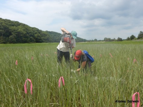
The site continues to be monitored for the success of the plants. State Parks staff will also observe changes in the marsh elevation using Surface Elevation Table monitoring stations (SETs), which were installed in the restoration site and a control site downstream. The elevation of the marsh surface may change in the future as mud is washed up and sea level rises. To learn more about SETs and how they are used, click here.
To learn more about the tidal creek and salt marsh habitat at Sunken Meadow State Park, check out some of our educational programs! NYS Parks works with local schools to engage students in citizen-scientist projects. A seasonal intern leads nature walks and uses the mobile touch tank to share the tidal world with park patrons. Sunken Meadow also participates in the “A Day in the Life of the Nissequogue River” program, which you can learn more about here.
To find out more about programs available at Sunken Meadow State Park, check the calendar.
Post by Juliana Quant, State Parks
Sources
Connecticut Fund for the Environment, 2013. Sunken Meadow Comprehensive Resilience and Restoration Plan. National Fish and Wildlife Foundation – Hurricane Sandy Coastal Resiliency Competitive Grants. EasyGrantsIS: 42442.