Four-Legged Grounds Crew

One hundred Southdown sheep once mowed the expansive lawn of William Rockefeller’s estate, Rockwood Hall, in North Tarrytown, NY.  A century later sheep and goats are grazing once again, but now the property is part of Rockefeller State Park Preserve (Preserve) in the renamed community of Sleepy Hollow.

sheep1
Sheep grazing at Rockefeller State Park Preserve.

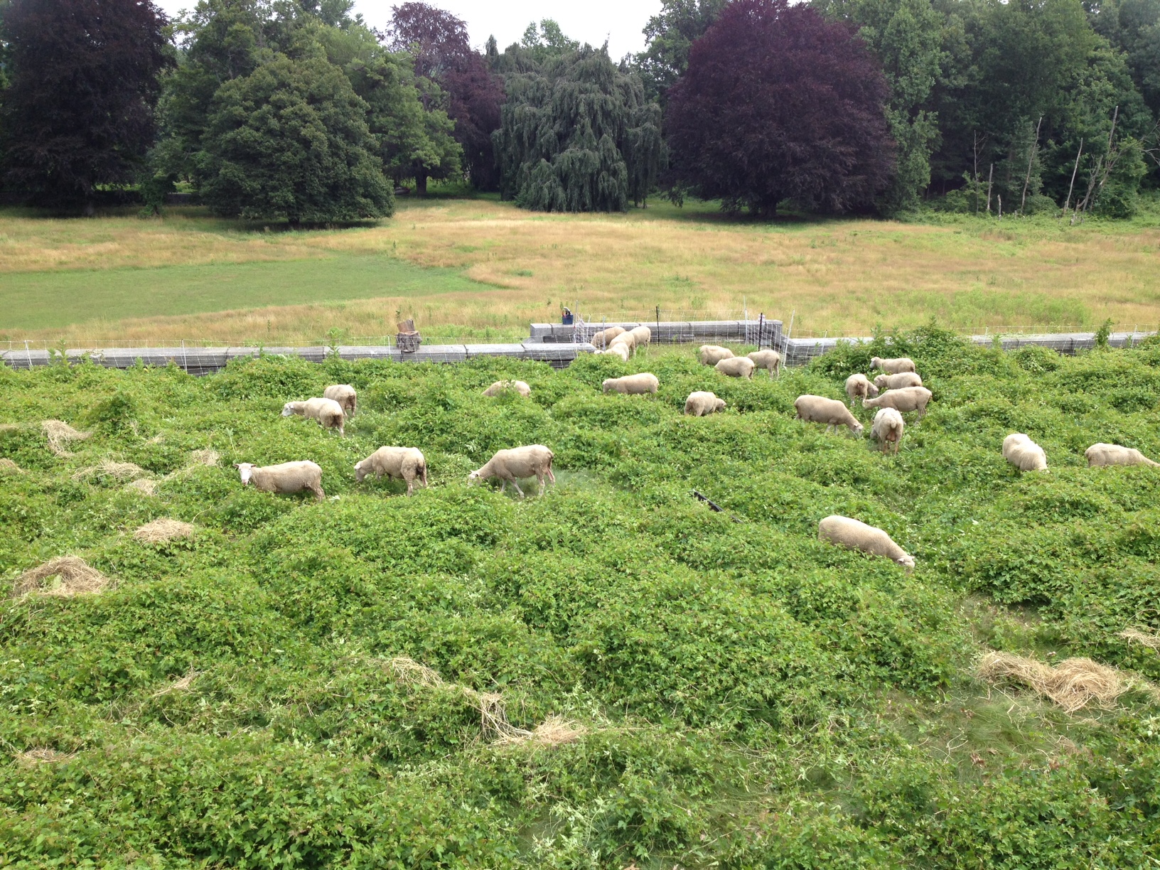
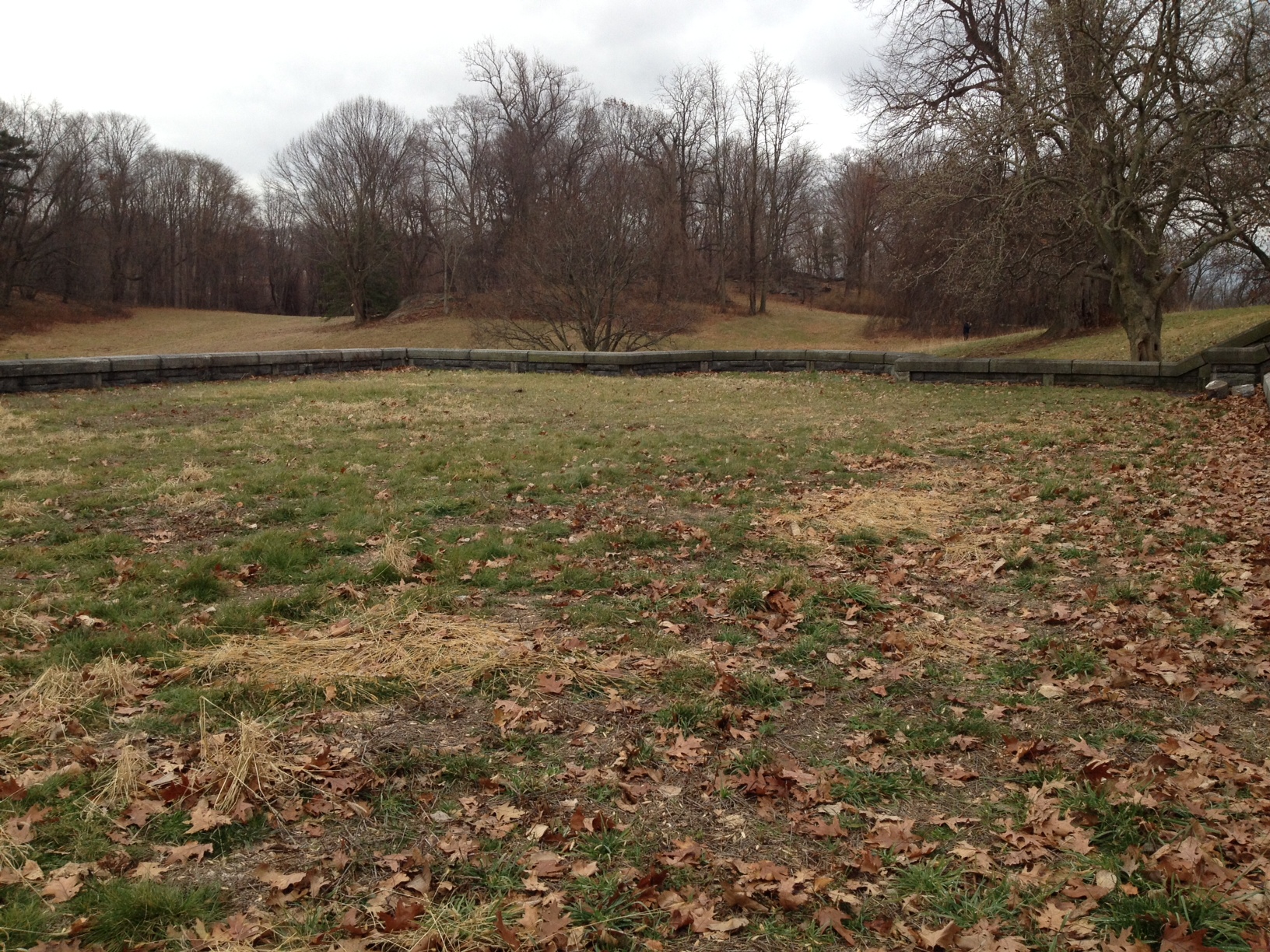
Over recent years, the steep slopes and historic stone foundation overlooking the Hudson River became overrun by the highly invasive akebia vine (Akebia quinata), porcelainberry vine (Ampelopis brevipedunculata) and other invasive species.  To control the vines and manage the grassy hillsides, the Preserve has partnered with Stone Barns Center for Food & Agriculture, a neighboring non-profit working farm and education center, to rotate sheep and goats around the foundation.  Stone Barns gets more grass and forage for their sheep, while public lands get invasive species more under control in an ecofriendly way.

The project was begun in mid-summer of 2014 with 50 sheep augmented by 7 goats over four months.  This year Rockwood Hall will host 10 Boer goats, 30 Tunis sheep and 50 Finn Dorset sheep. They are rotated every 4-6 days through small paddocks enclosed with temporary electric netting and peripheral fencing.   Chris O’Blenness, a farmer employed by Stone Barns Center, is managing the flock and stays on-site at night in a travel trailer.

This is the first joint Rockefeller State Park Preserve-Stone Barns Center experiment aimed at improving landscape health and ecosystem function.  It is also a potential strategy for increasing access to land for beginning farmers.  Chris O’Blenness is representative of beginning farmers and ranchers who are searching for land to work. This type of symbiotic grazing arrangement on public lands is a potential model for other public lands that can offer beginning farmers affordable opportunities for land access—all while performing a vital public service and delighting Preserve visitors.

Envisioned as a multi-year initiative, this on-going land management is needed to make headway against the fast-growing spread of invasive species.   So far grazing is making a difference, but progress would be lost if grazing were stopped.  Although 90 grazing animals sounds like a lot, it’s not on a large landscape.  We have also added weedwacking and mowing to the rotation.  Since the grazing started, one terrace, once engulfed in a 3 foot tangle of thick porcelainberry vine, is now able to be mowed weekly and visitors are able to spread blankets on grass and picnic where no one dared before.

sheep2
Terrace with porcelainberry in the summer of 2014.
sheep3
The same terrace in December of 2014 after grazing and mowing.

As the Preserve and Stone Barns gain experience and increase numbers of animals, we’re hoping to fine-tune the grazing to achieve ecological and foraging goals.  Meanwhile, the baas of the sheep and goat greet visitors, many of whom now stop and look and think about invasive species and land management challenges.

Post and photos by Susan Antenen, Rockefeller State Park Preserve Manager.

Looking at the Big Picture: Implementing Ecosystem-Based Management in Parks

Ecosystem-Based Management, sometimes referred to as EBM, is a planning tool. It helps guide decisions on where to place development such as roads, buildings, trails, beaches etc., while also considering the long and short term impacts to the environment. It also looks at how development effects not just the surrounding environment, but also the upstream and downstream environment.  EBM helps remind us to take the big picture view when we do work in our State Parks.

New York State Parks’ Environmental Management Bureau has been implementing Ecosystem-Based Management (EBM) in our parks statewide since 2008.

EBM relies on citizen participation, partnerships, science-based approaches, and taking a long-term view   to provide an informed and adaptive approach to protecting our ecosystems while providing park patrons with experiences that connect them to the natural world.

There are 6 main components to EBM. These include:

  1. Place-based focus;
  2. Scientific foundations used for decision-making;
  3. Measurable management objectives to direct and evaluate performance;
  4. Adaptive management to respond to new knowledge;
  5. Recognition of interconnections within and among ecosystems; and,
  6. Involvement of stakeholders.

Taking this approach allows us to look at interacting systems, like watersheds, rather than individual components, such as a specific plant or animal or isolated water quality parameters.  NYS Parks has used this approach to help better understand, protect and manage our resources, such as swimming beaches, lake water quality, forest health, species richness, and aquatic connectivity.

In addition to helping us look at our natural environment in a more integrated way, EBM provides a means to communicate with multiple stakeholders including citizens, scientists, the private sector and government officials.

Ecosystem Based Management Education Panel_1

Ecosystem Based Management Panels at Sunken Meadow State Park on Long Island.
Ecosystem Based Management Panels at Sunken Meadow State Park on Long Island. Click to enlarge images.

NYS Parks will continue to integrate EBM into programs andactivities through training, watershed educational materials and ecosystem research, as well as projects which demonstrate that healthy ecosystems mean healthy communities.  Look for these EBM educational panels at Sunken Meadow State Park on Long Island (pictured above)! More educational panels and kiosks showing how our parks are part of the larger landscape are in the works for parks along the St. Lawrence River and Great Lakes.  Keep an eye out for them!

Post by Gabriella Cebada Mora, OPRHP.


Invasive Mussels & Snails of Lake Champlain

In my two months as a New York State Parks Boat Steward on Lake Champlain I have already collected two aquatic invasive species: the banded mystery snail and the zebra mussel. I encountered the banded mystery snail at two different boat launch sites by the shore of Lake Champlain near Point Au Roche State Park. The zebra mussels are often found attached to rocks, driftwood, and recreational equipment that has been in the water for some duration.

The banded mystery snail is native to the southern United States and its introduction to this region can be traced back to 1867 when an amateur biologist released 200 of the snails into the Hudson River. This event was followed by subsequent introductions from aquariums owners. The snails can grow to be 1.75 inches long and 1.5 inches wide, with anywhere from one to four red bands on the shell. This species also lives in very high densities. Scientists are still studying the ecological effects of banded mystery snail invasion on natural communities. However, the presence of the species has been shown to decrease the survival rates of large mouth bass eggs in ponds and in the lab, which may eventually lead to a decline in fish populations in Lake Champlain.

The zebra mussel is an aggressive species that has spread very quickly since its first introduction to North America from Russia in 1989. By the mid-1990’s the species had become established in Lake Champlain. It is a D-shaped mollusk that is less than 2 inches long and has a distinctive brown zebra pattern on the shell. It poses great threats to native environments because it lives in dense populations of up to 750,000 specimens per square meter. Zebra mussels will attach themselves to any hard surface including native mussels, plants, man-made objects (such as piers and boat motors), and will even adapt to live on soft sediment. They are able to attach to objects by spinning a mass of tiny fibers called byssal threads that allow them to cling to any surface. Their larvae (veligers) are microscopic and float near the surface of the water which makes them easily transportable by boats or any recreational watercraft. Zebra mussels are strong competitors. One way that they outcompete native species is by grazing on large volumes of phytoplankton, thereby reducing the food resources available for native mussel species. They also take up large amounts of space on the lake substrate that is needed for fish spawning. Additionally, they cause drastic economic damage each year by  clogging pipes and pumps at wastewater treatment facilities and damaging municipal drinking water systems, hydroelectric power plants and irrigation systems.

ariana inspection
Ariana London completing a boater/angler survey about aquatic invasive species at the Great Chazy River Boat Launch (north of Plattsburgh on Lake Champlain). Photo by Megan Phillips, OPRHP.

While it is possible that Lake Champlain may never be free of the zebra mussels and the banded mystery snail, we can still ensure that these species do not spread to ponds, lakes and streams that are not yet infested. I feel incredibly honored to be part of the effort to stop the spread of the aquatic invasive species by educating people on what they can do to help.

Remember to clean, drain and dry your watercraft after use. To reduce the risk of spreading invasive mussels and snails in their veliger stage, boaters may opt to wash their watercraft and flush the engine with hot water. Research indicates that zebra mussels in the veliger stage cannot withstand water warmer than 110 degrees Fahrenheit, and adults will experience mortality at temperatures greater than 140 degrees Fahrenheit. For a list of hot water, high pressure boat washing station in the North Country/Adirondack Park area, click here.

Post by Ariana London, OPRHP Thousand Island Region Boat Steward.

Sources:

http://www.nps.gov/isro/planyourvisit/upload/ZMBoaters.pdf

http://www.watershedmanagement.vt.gov/lakes/docs/ans/lp_zeeb-factsheet.pdf

http://www.adkwatershed.org/invasive-species/invasive-species-information/zebra-quagga-mussel

https://adkwatershed.wordpress.com/2014/04/17/banded-mystery-snail-vs-chinese-mystery-snail/

http://www.lcbp.org/wp-content/uploads/2012/08/LCB_Invasive_Species_Guide.pdf

http://nas.er.usgs.gov/queries/FactSheet.aspx?SpeciesID=1047

Rebuilding NYC After the Great Fire: Clay Mining on Staten Island

In 1836 Balthasar Kreischer emigrated from Bavaria to New York City with plans to help rebuild the city after the devastating fire the previous year.  The Great Fire of 1835 burned across 50 acres and destroyed 674 buildings.  Kreischer and his partner, Charles Mumpeton established the Kreischer Brick Manufactory, a firebrick businesses with locations in Manhattan, Staten Island, and New Jersey.  In the neighborhood now known as Charleston on Staten Island, he began mining for clay that would then be shipped to brickwork factories in Manhattan.  The business flourished until Kreischer’s death in 1886.  A few years after his death, the factory burned down, and although it was rebuilt, the business never recovered.

The remnants of the clay mining are still visible today from the hiking trails of the park.  Some of the clay pits have filled with water and provided habitat to new flora and fauna, while others remain dry and are home to flourishing skunk cabbage.  There are areas along the trails where you can still find signs of the former inhabitants of the area, untouched glimpses into the lives of those who once lived in this beautiful area.  Outside of the Interpretation Center are some of the historic Kreischer bricks in the walkway, guiding you away from the rush of city life and into the quiet serene that is Clay Pit Ponds State Park Preserve.

balthasar kreischer
Balthasar Kreischer. Image courtesy of the Staten Island Museum Collection.
kreischer bricks
Kreischer bricks at Clay Pit Ponds State Park Preserve.

Post by Clare Carney, OPRHP, Clay Pit Ponds State Park Preserve.


Finding the Footpaths: Creating Trail Maps for New York State Parks

Almost every state park facility in New York has a trail system. As such, it is important that each park have a trail map so visitors can find their way around. Several steps go into creating a trail map including: talking with the park manager, going into the field, and analyzing the data.

The best way to obtain data is by using a Geographic Positioning System (GPS) unit. Parks uses the Trimble GeoXT, which makes a digital map as it collects points, documenting the route travelled as well as any important features. This particular unit comes with a backpack-mounted antenna to increase satellite reception, which is important in heavily wooded areas.

trimbles
Trimble GPS units. The GeoXT, on the right, creates a map in real time. The GPS captures lines and points, takes pictures and is water resistant.

The first step is to talk with the park manager about what he or she wants. It may be that the park has no trail map, only a small portion needs to be updated, or the park is seeking approval on a proposed route. Before heading out, the surveyor uploads reference data to the GPS including park boundary, existing trails and any other useful data. Then, they go the park and start hiking.

maddy 1
Maddy Gold collecting data in Clarence Fahnestock State Park.

In the field, it is important to document every trail, even if it is not an official trail. This is important for rescue teams trying to locate an injured person within the park. Other notable features to collect include: scenic views, picnic areas, restrooms, parking lots, bridges, eroded areas, blaze color, and more.

When the surveyor is confident they have collected all relevant data, they take the data back to the computer and put it into a program called GPS Pathfinder. This program corrects for any inaccuracies in satellite reception by matching the points against current imagery.

mapping 1
GPS Pathfinder Office with data and Differential Correction Wizard. This software corrects for satellite discrepancies and produces the most accurate data possible.

The last step is to put the corrected data into GIS (Geographic Information Systems). This program allows the surveyor to produce a map using the features recorded on the GPS. With all the information about the park in hand, the surveyor sends a draft of the trail map to the park manager. When the park manager is satisfied, the map can be published for use by the public.

mapping 2
ArcGIS window showing the shape file for the state of New York.

Post by Maddy Gold, OPRHP SCA Intern.

The official blog for the New York State Office of Parks, Recreation & Historic Preservation