It is a lovely day in the early summertime, 80o and sunny, with a gentle breeze. Outdoor educators Daniel Marshall and Ursula Svoboda from the Taconic Outdoor Education Center are preparing to guide weekend canoe tours on beautiful Canopus Lake located in sprawling Clarence Fahnestock Memorial State Park in Putnam County.
“What a gorgeous day to be out on the water!” proclaims a very eager Marshall.
“I hope we see a bald eagle like last time!” replies Svoboda.
No matter the canoe tour guide, a visitor is in for a treat, as all of the educators (guides) from the nearby Taconic Outdoor Education Center. These guides are friendly, knowledgeable, and bring their own unique perspective on the natural history and ecology of the region. The hour and a half tour circles the shoreline of the 65-acre lower portion of the man-made lake, weaving in and out of numerous small islands.
The lake, built by the Civilian Conservation Corps (CCC) in the 1930s, is both a recreational and ecological jewel in the park. In summer, you can find people swimming and sunbathing, paddling in kayaks, and fishing for largemouth bass and yellow perch along the shoreline. Chain pickerel, brown bullhead catfish, and black crappie also lurk through the aquatic plants below the surface. A lake such as Canopus, although made by humans, provides a very rich ecosystem. Other critters that spend most of their time in the water include painted turtles and water snakes such as northern water snake and black rat snake. There are even predacious water beetles in the lake; beetles are large enough to eat small fish!
Predaceous Diving Beetle, photo by cotinis
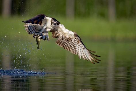
Canopus Lake also attracts animals from the forest ecosystem that may be looking for a drink of water or a place to hunt along the water’s edge. Beaver activity is evident with toppled trees along the shoreline and a large wood/mud dam near the CCC dam. Osprey (state special concern species), bald eagles (state threatened) and other birds of prey soar overhead. Osprey are excellent at fishing, plunging into the water and, more often than not, emerge with a fish in their talons. What makes this canoe trip so exciting is that one really never knows what they might be lucky enough to observe when out on the water!
North osprey grabs a yellow perch
Canoe tours cost $5 per person and leave from the park’s boat launch along Route 301 just south of the park office. Some of the boats can accommodate four people (two paddlers and two passengers.) Reservations are encouraged by calling (845) 265-3773. Come experience this fun summertime activity for yourself!
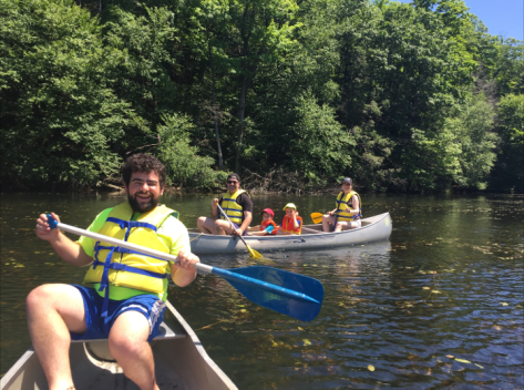
Post by Aaron Donato, State Parks
Fun times canoeing on Canopus Lake, photo by Aaron Donato
Don’t let the snow deter you from exploring State Parks – just grab or borrow a pair of snowshoes and head out to the trail. Go snowshoeing on a trail in a nearby park or try one of State Park staff’s favorite snowshoeing spots.
A group pauses during a snowshoe trip at Wilson-Tuscarora State Park, photo by State Parks
In western New York, Tina’s favorite snowshoeing spot is at Wilson-Tuscarora State Park located on Lake Ontario in northern Niagara County in Wilson. This is where you will find the Red interpretive trail nestled along the east branch of Twelve Mile Creek. As you snowshoe through the changing landscapes, you’ll pass through successional fields, marshland, and finally through a mature forest of old growth beech and hemlock trees. Keep your ears open for calls of the pileated woodpecker.
Snowshoe to this historic tower at Allegany State Park, photo by Adele Wellman, State Parks
At Allegany State Park in Salamanca, Adele recommends the Bear Paw Trail located across the road from the Art Roscoe cross-country ski area on the Red House side of the Park. Bear Paw Trail is the newest trail built for the snowshoeing enthusiast. The 2.4-mile long, easy to moderate trail has 15 interpretative sights and runs along the ridge above Salamanca to historic Stone Tower. The trail loops through large stands of Black cherry and White ash trees. Look for small secret plants such as wintergreen and princess pines along the trail. Each Monday evening in January and February, the park offers sunset snowshoe hikes. The Environmental Education Department has a few pairs of snowshoes to borrow during programs.
In central New York, Katie’s favorite part about snowshoeing is how the landscape constantly changes during the winter. Even if you snowshoe at your favorite local park, in her case Clark Reservation State Park in Jamesville, everything looks different in the winter.
After the leaves fall off the trees, you can see so much farther into the woods. You will be snowshoeing along at Clark Reservation, and suddenly notice that the ground drops away not far from the edge of the trail into a steep ravine. You might never notice the ravine in the summer because rich greenery hides it from view. Winter’s arrival reveals forests secrets. Soon though, they are covered up again, this time with ever changing blankets of snow. Nature’s snow sculptures change daily, so you really need to hit the trails often so you don’t miss out!
About once a year, the park gets special permission to host a moonlit snowshoe hike it’s amazing how bright the forest is with the light from a full moon reflecting off the snow. You can even see your shadow! Keep your eyes on the calendar to find out when this year’s Moonlight Snowshoe Hike will be, or come out on your own any day to check out this special place.
Family fun at Wellesley Island State Park, photo by State Parks
At the Minna Anthony Common Nature Center at Wellesley Island State Park, Thousand Islands, Molly notes that there are four trails open to snowshoeing. Probably the most heavily snowshoed trail is North Field Loop. Only a half mile long, it meanders through a forest full of white pine trees, passes through a seasonal wetland, and into a forest of towering red oak trees. School groups explore this trail on snowshoes and the nature center staff lead moonlight snowshoe hikes on the trail throughout the winter months. There is nothing prettier than snow covered woods on a moonlit night. The park has both children and adult snowshoes available for rent for $3 a pair.
Snowshoeing through Grafton Lakes State Park, photo by State Parks
In the Capital Region, Liz at Grafton Lakes State Park suggests the Shaver Pond trail loop. Just under two miles, it offers picturesque views of Shaver Pond, with a trail winding through forest of hemlock and maple trees over easy terrain. Inquisitive visitors may see mink or fox tracks along the way. Trail maps are for sale & snowshoe rentals are available at park office on a first-come, first served basis for $5 for four hours.
Family snowshoe program at Moreau Lake State Park, photo by State Parks
At Moreau Lake State Park, Rebecca mentions that the park has 30 miles of trails and there are new places to explore as the seasons change. The parks offers snowshoe hikes and classes for all ability levels, including first timers. The park also has snowshoes available for rent to hikers or people who want to go out and try it on their own for $5 for a half day and $10 for a full day rental.
Fun times with friends at Thacher State Park, photo by State Parks
At Thacher State Park, the Fred Schroeder Memorial Trail is one of Nancy’s favorite snowshoe walks. This three mile loop in the wilder northern part of the park takes you through beautiful woodlands of mixed hardwoods with stands of spruce and hemlock trees and across a couple of open fields, without much elevation change. Midway on the loop, you can take in the scenic snow-covered views from the cliff edge at High Point. Emma Treadwell Thacher Nature Center rents snowshoes to the public.
Heading out on the trail at Fahnestock Winter Park, photo by State Parks
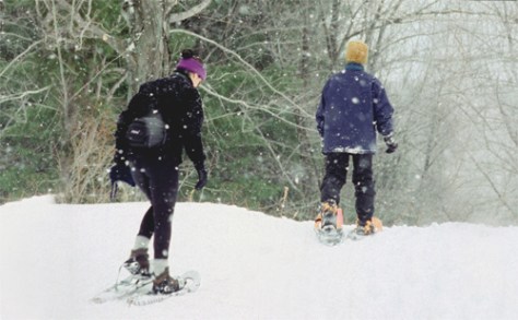
In the Hudson Valley, Kris at Fahnestock Winter Park mentions two unique snowshoeing trails. If you’re looking for more rugged terrain, and challenging descents, “Appalachian Way” treks along a ridge line to a stunning overlook of Canopus Lake. The trail “Ojigwan Path” offers the beginner and intermediate snowshoer a snaking walk through hemlock groves and strands of mountain laurel. Both routes take around 2.5 hours to complete. Snowshoe rentals are located in the newly renovated winter park lodge, where you can also warm up with a cup of delicious chili!
A beautiful day on snowshoes at Sam’s Point, photo by State Parks
Laura D. recommends a snowshoeing trail that will lead you to expansive cliff top vistas, through the globally rare dwarf pitch pine barrens, and around the glacially carved Lake Maratanza. The Loop Road at the Sam’s Point Area of Minnewaska State Park Preserve is the perfect trail for viewing these breathtaking vistas. While on the three-mile Loop Road, stop at the Sam’s Point Overlook, where on a clear day, you can see four states! Snowshoe rentals are available at the Sam’s Point Visitor Center for $15 per adult and $14 per junior (17 years and under) for the day or $5 to join a public program.
Minnewaska Falls, photo by State Parks
A novice snowshoer will find the modest Mossy Glen Footpath loop just right for a snowshoe trip at Minnewaska State Park Preserve notes Laura C. This approximately four-mile route follows the Mossy Glen Footpath as it hugs the edge of the scenic Peter’s Kill stream, winding through quiet forests. At the end of this Footpath, take the Blueberry Run Footpath to the Lower Awosting Carriage Road back to your starting point. This loop begins at the Awosting Parking Lot.
photo by State Parks
These are just a sampling of the many trails you can explore on snowshoes . We hope to see you out on the snowshoe trail this winter.
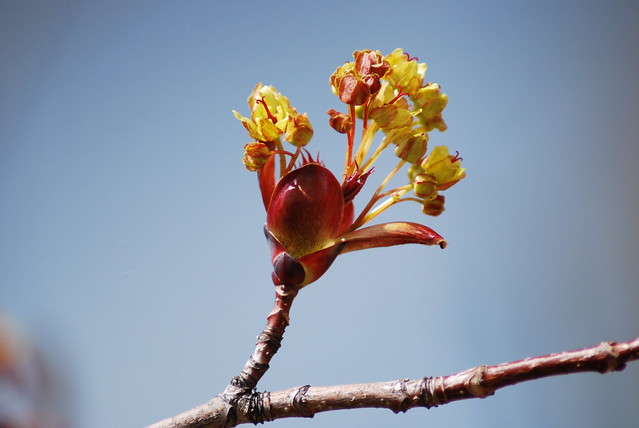
In the northeast, winter days can seem to drag on after the holiday season. Snowstorms seen to occur every three days and a constantly blowing wind chills the air to -10oF. It’s the type of weather that makes you wonder why humans don’t hibernate. While we can’t control the seasons; winter will always bring shorter days, the moon will revolve around the earth and the earth will revolve around the sun, we can change our mindset and that is what maple sugaring is about.
The maple sugaring season is almost a spiritual experience that lifts you through the last doldrums of winter. It ignites every sense. Imagine hearing the taps of sap into a metal bucket hung on a tree, the sweet steam lifting off the evaporator immersing your nose in warmth, the crackling fire fueling the evaporator, and of course the sweet taste of liquid gold. The whole experience does not occur unless the right weather conditions are present.
Hudson Valley Sugar Farm at the Taconic Outdoor Education Center, photo by Marlena Vera-Schockner
The release of sap in the spring is a sign that the trees are finally waking up from their winter rest. The ideal sap running conditions are warm days and cold nights. This temperature fluctuation causes the sap to run up and down the tree each day. The maple season may only last for as little as ten days, but they are an intense ten days. Intense because of the time needed to collect and boil down the sap, and it is the boiling down of the sap that takes the most time.
Do you ever wonder why pure maple syrup tends to cost five times more than pancake syrup? It because it takes 40 gallons of sap to make one gallon of pure maple syrup! There is a lot of energy involved to boil down the sap that contains 2% sugar to the sticky syrup containing 66% sugar content. Everyone around helps collect sap, tend to the evaporator, and bottle syrup. Tremendous effort goes into each gallon of syrup and it is all worth it in the end. There is no better feeling than creating something from start to finish and enjoying your success with the ones you cherish.
There are signs in nature that tell you when the maple season is over. The temperature stays above freezing during the night ceasing the sap to run up and down the tree. The buds on the trees start to burst open and the sap turns cloudy and is less sweet. A natural siren goes off-spring peepers serenade the woods as they emerge from their winter hibernation. It’s a bittersweet ending for the sugaring season. The transformation of sap to syrup is over for the year, but now the forest has come back to life and it is time for spring.
Learn more about maple sugaring by attending a program at a state park near you!
Almost every state park facility in New York has a trail system. As such, it is important that each park have a trail map so visitors can find their way around. Several steps go into creating a trail map including: talking with the park manager, going into the field, and analyzing the data.
The best way to obtain data is by using a Geographic Positioning System (GPS) unit. Parks uses the Trimble GeoXT, which makes a digital map as it collects points, documenting the route travelled as well as any important features. This particular unit comes with a backpack-mounted antenna to increase satellite reception, which is important in heavily wooded areas.
Trimble GPS units. The GeoXT, on the right, creates a map in real time. The GPS captures lines and points, takes pictures and is water resistant.
The first step is to talk with the park manager about what he or she wants. It may be that the park has no trail map, only a small portion needs to be updated, or the park is seeking approval on a proposed route. Before heading out, the surveyor uploads reference data to the GPS including park boundary, existing trails and any other useful data. Then, they go the park and start hiking.
Maddy Gold collecting data in Clarence Fahnestock State Park.
In the field, it is important to document every trail, even if it is not an official trail. This is important for rescue teams trying to locate an injured person within the park. Other notable features to collect include: scenic views, picnic areas, restrooms, parking lots, bridges, eroded areas, blaze color, and more.
When the surveyor is confident they have collected all relevant data, they take the data back to the computer and put it into a program called GPS Pathfinder. This program corrects for any inaccuracies in satellite reception by matching the points against current imagery.
GPS Pathfinder Office with data and Differential Correction Wizard. This software corrects for satellite discrepancies and produces the most accurate data possible.
The last step is to put the corrected data into GIS (Geographic Information Systems). This program allows the surveyor to produce a map using the features recorded on the GPS. With all the information about the park in hand, the surveyor sends a draft of the trail map to the park manager. When the park manager is satisfied, the map can be published for use by the public.
ArcGIS window showing the shape file for the state of New York.
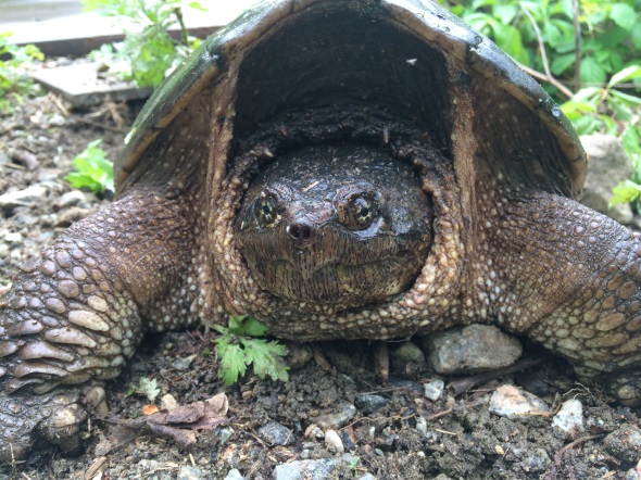
While conducting field work in Clarence Fahnestock State Park the Environment Management Bureau’s Wildlife Unit came across this large female snapping turtle in early June. This female snapping turtle was observed digging a hole in the sandy soil to lay her eggs. This time of the year a variety of wildlife are giving birth or nesting to produce this year’s offspring. Turtles, as you may know, do not move very fast on land and tend to get hit by vehicles while attempting to cross the road. Please watch out for them on the roadways! Snapping turtles and turtles in general look for sandy soils that are easy to dig in to create their nest and lay their eggs. Nesting can take place quite a far distance from water. This is okay! Once hatched, the baby turtles will find their way back to a water source nearby. Get out in nature, experience our beautiful wilderness and all it holds, but please remember to not disturb these natural processes and give wildlife some space to be wild.
Post by Kelly Starkweather, OPRHP Wildlife Unit.
Photos taken at Clarence Fahnestock State Park by Lilly Schelling, OPRHP Wildlife Unit.


