

With autumn leaves now turned, hiking in the Palisades region of State Parks offers spectacular views of the Hudson Valley and the Catskills to go with a fascinating history that includes an outlaw’s lair, the state’s early iron industry, and a traitor’s secret meeting place.
Located on the west side of the Hudson River, this region between the Capital Region and New York City stretches through Rockland, Orange, Ulster and Sullivan counties, and contains 23 parks and seven historic sites.
As with all hikes, there are few things to remember beyond carrying a mobile phone. Wear sturdy yet comfortable shoes or boots, bring water and snacks, and perhaps carry a camera, to capture what you see. Be mindful of hikes on steep terrain or that go near cliff tops. Having a small first-aid kit available in case of emergency is never a bad idea
Hiking poles are useful, and can transfer some of the stress of hiking from your knees and legs to your arms and back. And use a trail map, which is available online at each park website at https://parks.ny.gov/ and at the main office at each park. Check the park’s individual website to see if its maps can be downloaded to your iOS Apple or Android device, but a paper map is a good backup in the event of device failure.
These maps include Park facilities such as parking, park offices, nature centers, campsites, and boat launches in addition to the location, name and distance of each designated trail in the park. For some facilities, data is available as a Google Earth KML file or a map is available to download to your iOS Apple and Android mobile devices in the free PDF-Maps app. Learn more…
For the Palisades region, more information on hikes is also available online from the New York-New Jersey Trail Conference, and at the bookstore near Exit 17 on the Palisades Interstate Parkway.
It’s smart to know how long a trail is and how long it ought to take to finish. Since daylight is not an unlimited resource, especially in fall as days grow shorter, tossing a flashlight or headlamp into your backpack is a good form of insurance, should you unexpectedly find yourself on the trail as dusk approaches.
And, as the incidents of tick-borne diseases surge in the state, it is always important to check yourself for ticks after being outside, even if it is only time spent in your own backyard.
Rockland County
Rockland Lake State Park, 299 Rockland Lake Road, Valley Cottage, (845) 268-3020: The Nyack River Trail runs along the western short of the Hudson River between Haverstraw Beach State Park and Nyack Beach State Park. About five miles long, the level trail offers excellent river views. It is lined with crushed stone, and so is easy on the knees for a run, and also makes for an excellent bike ride or walk with a dog (must be leashed per NYS Parks rules). This trail also passes a county historical marker for the infamous “Treason Site,” where during the American Revolution in 1780 American General Benedict Arnold meet secretly with British spy Major John Andre to hand over plans for the capture of the strategic Patriot fortress at West Point. Thankfully, the plot was thwarted, with Arnold becoming one of the fledgling nation’s most despised figures.
Find a trail map here…


Harriman State Park, Seven Lakes Drive/Bear Mountain Circle, Ramapo, (845) 947-2444: At more than 47,500 acres, the second-largest State Park has more than 200 miles of hiking trails. At its northeastern edge, it borders Bear Mountain State Park as well as the U.S. Military Academy’s forest reserve. To the southwest lies the 18,000-acre Sterling Forest State Park. This vast park includes a large rocky shelter that was the remote hideout for a bandit named Claudius Smith, who led a gang of pro-British marauders during the American Revolution, known at the time by terrified local residents as “Cowboys.” To find it, go to the parking lot at the end of Old Johnstown Road, and look for the Blue Trail. Follow this steep trail to the top of Dater Mountain for its views, and then continue until you reach the rocky den, which had enough room to shelter both the gang and their horses. After taking in the panoramic views, which allowed the gang to see anyone coming, head down on the Tuxedo-Mount Ivy Trail to return to the parking lot. The hike is a five-mile trip, with one very steep section.
Find a trail map here…

Ulster County
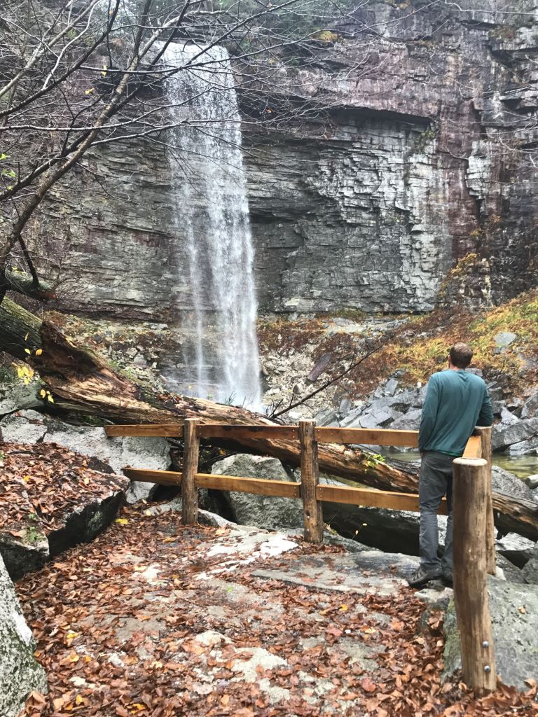
Minnewaska State Park Preserve, 5281 Route 44-55, Kerhonkson, (845) 255-0752: Take in Catskills from atop the Stony Kills Falls at the northwestern edge of the park on this short, but challenging one-mile hike. Start at the parking area at the end of Shaft 2A Road and follow the gravel trail that crosses two wooden bridges on its way to the base of the 78-foot waterfall. Follow a set of stone stairs upward, using iron hand holds and railings for safety, to reach the top of the falls and its sweeping northerly views. You can either backtrack to the parking lot, or connect to the Stony Kill Falls carriage road atop the Shawangunk escarpment to make a longer hike.
Find a trail map here…
Orange County
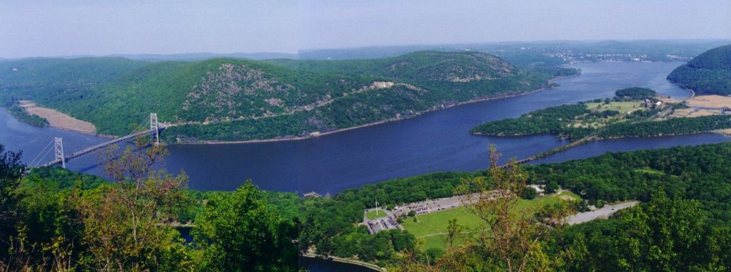
Bear Mountain State Park, Palisades Parkway or Route 9W North, Bear Mountain, (845) 786-2701: Take in the view of four states and even glimpse the Manhattan skyline from the Perkins Memorial Tower atop 1,289-foot Bear Mountain. Take the completely rebuilt Appalachian Trail, which features about 1,000 stone steps along a steep granite face. It took crews, including members of the New York-New Jersey Trail Conference, seven years of arduous labor to renovate the 1.5 mile trail up to the top. There is a new wooden bench at one of the lookouts for those who might find themselves in need of a breather on the way up.
Also at Harriman, photographers will enjoy the trail to West Mountain that starts at the Anthony Wayne Recreation Area. Start on the Fawn Trail to the Timp-Torn Trail, which takes you to the mountain ridge to the West Mountain Shelter. From there, return using Timp-Torn to the intersection of the Appalachian Trail westbound, which will lead to Beechy Bottom Road that returns to the main parking area. The moderate hike is about five miles.
Find a trail map here…

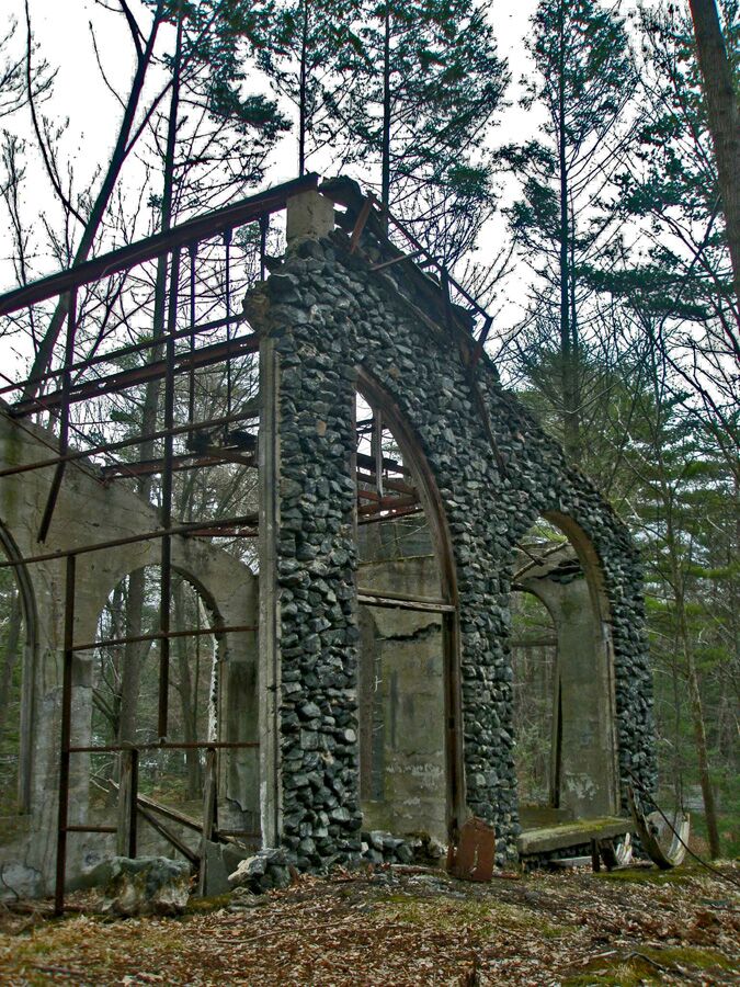
Sterling Forest State Park, 116 Old Forge Road, Tuxedo, (845) 351-5907: For larger groups or school trips, there is the Lakeville Ironworks Trail Loop, which takes in the remains of an iron industry that once dominated the area. At about a mile long, the easy loop includes views of Sterling Furnace, the Lake Mine, and other mining remnants. This trail is among more than 30 trails, including the Appalachian Trail, within a 21,935-acre park in the midst of the nation’s most densely populated areas.
Find a trail map here…
Cover Photo of West Mountain summit view by Abigail Leo Parry, manager of Beaver Pond Campground at Harriman State Park.
All photos from NYS Parks unless otherwise credited.
Post by Brian Nearing, deputy public information officer at NYS Parks
