While the ground may soon be frozen or covered in snow (or not), that doesn’t mean the hunt for a hidden treasure in a state park has to stop.
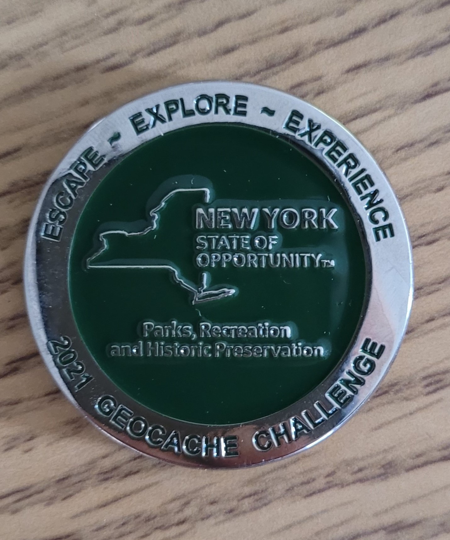
Through this summer and fall, more than 220 people searching in three State Parks regions found enough geocaches – hidden little containers of trinkets whose locations are identified by Global Position System (GPS) coordinates – to be awarded special 2021 New York State Geocache Challenge coins.
To earn the coins, geocache hunters had to locate at least 45 out of more than 230 concealed caches, with 35 “finds” coming from one of the three regions and the balance from either of the other two regions. Cache-seekers used coordinates with their own GPS devices to locate the caches, and were able to take some trinkets and leave some of their own for subsequent seekers to find.
Altogether, nearly 4,700 people took part in the seasonal challenge, which wrapped up in mid-November and covered 56 state parks and historic sites in Central New York, the Saratoga-Capital District Region, and the Hudson Valley. Odds of finding enough caches to earn a coin worked out to roughly 1 in 20. So obviously, the caches were not in plain sight!
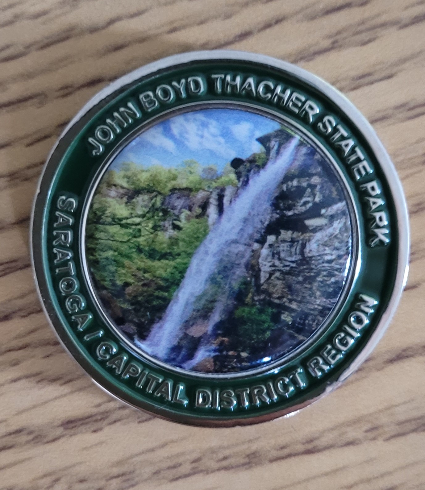
Use the slider bar to compare the front and back of the 2021 New York State Parks Geocache Challenge coin. This coin was available in the Saratoga/Capital District Region, where 78 people found enough caches to qualify for the free coin.
This season, three Parks regions are hosting winter geocache events,
Tthe Saratoga-Capital District Region is hosting a “Winter 33” Geocache Challenge, which will offer 33 “winter-friendly” caches placed in three parks in the region. This challenge will run from Jan. 15 to April 15, 2022. There will no geocoins available during this winter challenge, so it it all just for the fun of it!
In the Taconic Region of the Hudson Valley, the 2022 Winter Geocache Challenge will take place at Lake Taghkanic State Park in Ancram, Clarence Fahnestock Memorial State Park in Cold Spring, and Mills Norrie State Park in Staatsburg.
And in the Central Region, there will nearly 70 geocaches placed at 14 Parks and Historic Sites, including Battle Island, Fort Ontario, Green Lakes, Chenango Valley, Robert Riddell, Glimmerglass, Hyde Hall, Herkimer Home, Chittenango Falls, Clark Reservation, Old Erie Canal, Lorenzo House, and Verona Beach.
And what might a “winter-friendly cache be? Well, that means the items will be hidden in a way that prevents them from being buried in the snow, such as being hung from tree branches or tucked up under a bench or a picnic table.
To find the caches, download the Geocaching app or follow the coordinates of the caches listed on the Geocaching.com website. When you find a cache, stamp your passport with the stamp inside each cache the turn it in to the state park indicated on the passport. Remember to leave the stamp behind for others that come after you.
Geocaching in winter presents its own challenges of snow and cold weather. Make sure to dress for the weather, with warm clothing, gloves and winter boots. Carrying extra water during the winter is advisable to avoid dehydration. And always carry a flashlight or headlamp, as daylight hours are shorter in the winter.
The geocoins awarded previously are trackables, since each coin carries a unique identifying number that can be activated online and then tracked as coins are located, reported and moved to new locations by their owners or subsequent geocachers. “Owners” of the geocoin, along with anyone else who knows its number, can follow its travels online.
So far, the geocoin that has traveled the farthest from a state park is from the 2015 Saratoga-Capital District Region Geocache Challenge. Most recently located in the southernmost point in the U.S. on the Big Island of Hawaii last month, this token (TB6Y60Y) has so far trekked 190,655 miles to such places as the Mediterranean island of Malta, Germany, the Kapaleeshwarar Temple in India, Japan, Israel, and more than 350 other places.
According to the owner’s page, they want to “travel to at least one state park in each state across the USA.” Now there is a mission that we can all get behind!
I am not stealthy. This is not new information, but I didn’t realize how sloppy I was at sneaking around until I tried geocaching—a worldwide game of locating some of millions of little hidden stashes. This outdoor activity relies on the use of Global Positioning System (GPS) technology, where participants place caches of trinkets, also…
Before State Parks could purchase 131 acres of Saratoga County forest to add to Moreau Lake State Park in 2018, staffers first had to find out about all past owners of that land – back to the beginning of written records.
As anyone who has ever purchased a home knows, information on past ownership is addressed in a process called a title search. Property records uncovered in such searches are normally covered by a special kind of insurance meant to protect the buyer of a property against claims over disputed ownership that might arise after the sale.
However, since New York State cannot purchase title insurance on land, it had to ensure that there were absolutely no hidden claims lurking from the past in the potential Moreau purchase. For State Parks, the only way to do that was to follow property records as far back as possible.
This historical detective work stretched back more than three centuries, to a controversial royal land grant during New York’s colonial period that covered Native American lands in what is now much of Saratoga County, as well as parts of Montgomery, Schenectady and Fulton counties.
Called the Kayaderosseras Patent, this land transfer was issued in 1708 by a Royal Governor of some ill repute named Lord Cornbury, who under dubious circumstances bestowed up to 800,000 acres north of the Mohawk River and west of the Hudson River.
Ownership of that land was a disputed tale riddled by claims of fraud and missing records, with Native Americans saying that the Colonial patent holders grossly overstated what originally was intended to be a very modest land sale. And the entire affair took six decades to untangle…
Based on a shadowy alleged sale agreement dated several years earlier from native Mohawk tribal leaders, Cornbury awarded this massive tract of land to 13 prominent Colonial citizens of the time _ all in exchange for official fees, of course. The group included such well-connected players as the colony’s Attorney General, several prominent Albany residents, and some Manhattan businessman of Dutch ancestry, with one of them named Joris Hooglandt.
The land patent in colonial New York was an important unit of settlement, along with the large manors of the Hudson Valley—preeminent among them the Van Rensselaer Manor, or Rensselaerwyck, which covered much of present-day Albany and Rensselear counties, as well as parts of Columbia and Greene counties, and Livingston Manor further to the south in Columbia and Dutchess counties. These areas were governed by powerful and wealthy patroons who enjoyed sweeping authority over land usage.
Prior to the American Revolution, land patents were issued by the English Crown or colonial authorities to individuals or groups as a means of encouraging settlement of the sparsely populated frontier. To those who were granted patents fell the responsibility of surveying, subdividing and conveying parcels to new settlers, which were offered either as freehold land or otherwise as land occupied under lease agreement, as was the case of the quasi-feudal manor system.
The Kayaderosseras episode can be seen as an early example of the dispossession of Native American lands that was to occur repeatedly throughout American history in the years that followed it. Here in the 21st century, the story of this land can be updated to reflect a more nuanced point of view on past decisions and actions that might not now be seen as just or exemplary.
Kayaderosseras Patent survey (Source- Saratoga County Historian)
On the left, a map of present-day Moreau, with the 2018 addition to Moreau Lake State Park highlighted in green. To the right, an 1866 atlas of Moreau shows the outlines of portions of the Kayaderosseras Patent, highlighted in orange. A small orange arrow points to Moreau Lake.
The shadowy origins of this patent were described in an 1878 history of Saratoga County by Nathaniel Bartlett Sylvester:
“By far the largest and most important land-grant made in colonial times, any part of which lay within the bounds of Saratoga County, was the patent founded on the old Indian hunting-ground of Kay-ad-ros-se-ra. This large tract includes the greater part of Saratoga County, and runs also on the north into Warren county, and on the west into Montgomery and Fulton.
Kay-ad-ros-se-ra, “the country of the lake of the crooked stream,” as has already been seen in these pages, was the favorite hunting-ground of the Mohawk branch of the Iroquois or Five Nations of central New York. The Indian deed was obtained of the Mohawk chief in the year 1703, but the patent was not granted till the year 1708, and the Indians did not ratify the purchase till the year 1768. This patent was, therefore, disputed ground for more than sixty years.”
According to the online description by the New York State Museum, the alleged size of the Kayaderosseras patent later was reduced by Colonial officials, but still was claimed to encompass more than 250,000 acres.
However, these supposed new owners took no action on their land patent for decades, with property interests changing hands during the years before steps to conduct land surveys finally started in the aftermath of the French and Indian War in the 1760s, which settled that the British, and not the French, would control North America. By that time, due to subsequent sales, deaths and inheritances, interests in the land patent had spread out to among some 130 colonists.
Sylvester’s story continues:
“At length, in 1763, the French and Indian war being over, the patentees of Kayadrossera began to look, with longing eyes, after their lands. In the year 1764, some one of them began to issue permits to settlers to enter upon and occupy portions of the patent.
In pursuance of these permits, several families moved upon the patent in the vicinity of Saratoga lake, at the mouth of the Kayadrossera river.
In the fall of that year the Mohawks, upon their hunting excursion, fell upon these settlers and drove them away.
Learning from the settlers that they claimed it by purchase, the Mohawks became alarmed, as they said they had never heard of such purchase.
The Mohawks at once appealed to Sir William Johnson, and were surprised to learn that the whole of their favorite hunting-ground had been deeded away by their fathers more than two generations before.”
It is telling who the Mohawks turned to as their advocate. Johnson, whose home in Johnstown, Montgomery County, is now a state historic site, was the largest single landowner and most influential individual in the colonial Mohawk Valley. His success and fairness in dealing with the Mohawks, as part of the Six Nations of the Iroquois, greatly influenced England’s victory over France for control of North America.
For his service, the British Crown bestowed upon Johnson the title of Baronet, and appointed him Superintendent of Indian Affairs, a position to which he devoted himself and held throughout his life.
It is important to note that Sylvester was writing as a resident of the mid-19th century, a time when the U.S. was fighting a series of violent wars against the Native Americans of the Great Plains. His viewpoint was likely informed by the predominant viewpoint that Native lands had to be taken, by force if necessary, for the United States to grow.
As Sylvester returns to the saga where the Mohawks turned to Johnson for help with the alleged decades-old sale of their lands:
“Sir William took up the matter warmly in favor of the Mohawks, and made every effort in his power to have the patent set aside.
In the first place, Sir William wrote to Lieutenant-Governor Colden, stating the case as he understood it, and urging relief. That very autumn, Sir William introduced a bill into the Colonial Assembly to vacate the patent on the ground of fraud.
These measures failing, in the year 1765 Sir William appealed to the council in person in behalf of his dusky brethren, but the members of the council put him off with, among other things, the plea that to vacate the patent in council would be disrespectful to the council who granted it. By this time the controversy had been taken up warmly by all the tribes of the confederacy of the Six Nations, and Sir William in their behalf petitioned to have the patent vacated on the ground of fraud by act of Parliament.
At length the proprietors themselves became alarmed for the safety of their patent, and offered to compromise with the Indians by paying them a certain sum of money to satisfy their claim. The Mohawks thought the sum offered too small, and the effort failed.
Thus the matter went on till the year 1768, when the proprietors of Kayadrossera gave to the governor, Sir Henry Moore, full power to settle with the Indians. In pursuance of this authority, Sir Henry proceeded to the Mohawk country in the early summer of 1768, and called a council of the Indians to deliberate upon the matter. But it was found that the proprietors had no copy of the Indian deed to produce in evidence on the occasion, and that, as no survey had ever been made, no proper understanding of the subject could be arrived at, and the council was dissolved.
Upon his return to New York, the governor ordered a survey of the patent to be made. The outlines of this great patent were accordingly given by the surveyor-general, and, the boundaries being ascertained, a compromise was arrived at. The proprietors relinquished a large tract on the northwestern quarter of what they had claimed to be their land, and fixed the northern and western boundaries as they now run. They likewise paid the Indians the sum of five thousand dollars in full of all their claims and the Mohawks thereupon ratified the patent and forever relinquished their claims to their old favorite hunting-ground.”
Ultimately, with Johnson’s intervention, the once-gigantic Kayaderosseras land grant was reduced to about 23,000 acres as part of a compromise that eventually concluded the sale in 1768, according to State Museum records.
And this brings our story full circle at last…
The new portion of Moreau Lake State Park so recently added was among the patent lands awarded in 1708 to Joris Hooglandt, the Dutch merchant who lived in Colonial Manhattan. He died in 1712, and there is no record that he ever saw or did anything with the disputed land that he allegedly owned.
In 1723, his children sold their claim to the widow of Hooghlandt’s brother. And in 1770, with the dispute finally settled, descendants of that family ended up with two of the original 13 patent shares, making it the largest single largest land distribution that could be traced back to an original party.
Over the years, this land was sold many times privately before finally becoming part of Moreau Lake State Park in 2018.
This new parcel at Moreau Lake State Park encompasses multiple summits, including portions of the Palmertown Range, and affords dramatic views of the Hudson Valley and southern Adirondack Mountains. The park was 700 acres when established in 1968, and has since grown to about 6,100 acres.
And this land, like all land, has a story to tell, which in this instance may help state residents further examine and appreciate some lesser-known aspects of our shared history.
Post by Brian Nearing, Deputy Public Information Officer; Travis Bowman, Senior Curator, Bureau of Historic Sites, and William Krattinger, Parks Survey Project Director.
Cover Photo: Historical maker on the Kayaderosseras Patent in Ballston Lake, Saratoga County. (Courtesy of Saratoga County Historian and William G. Pomeroy Foundation)
Sources:
New York State Museum link of the Kayaderosseras Patent.
Read a Daily Gazette account of an 1812 copy of the Kayaderosseras Patent map being restored and put on display at the Saratoga County Clerk’s Office in the village of Ballston Spa, which was first settled in 1771, the year after the disputed land patent was resolved..
Follow this link to an 1866 map of Saratoga County, showing the outlines of the patent, maintained by Clark University.
A rain garden is a plant-filled shallow depression that collects rainwater (stormwater) runoff. Rain gardens are a great do-it-yourself project for homeowners to manage small amounts of stormwater on their own property. By directing runoff into the garden, the rain that falls on rooftops, driveways, and other impervious surfaces on your property infiltrates into the ground. The water in the ground recharges local and regional aquifers instead of running off across roads and parking lots eventually polluting local waterways.
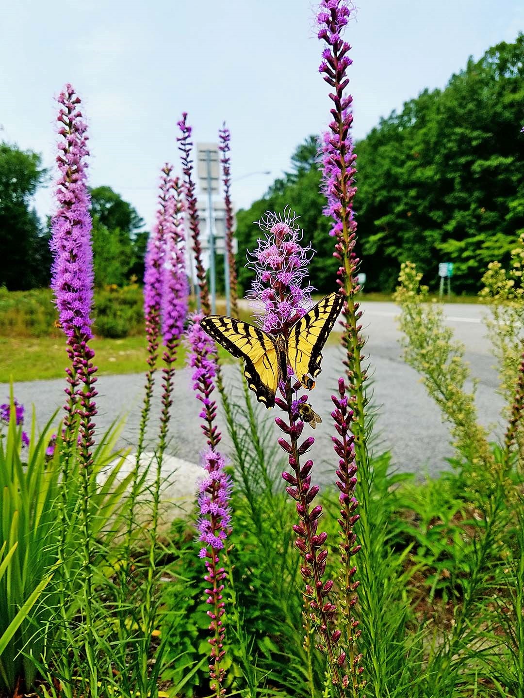
Rain gardens are pollinator gardens too! A tiger swallowtail is nectaring on the blazing star (Liatris spicata) in this rain garden.
Rain gardens are beneficial in many ways
In addition to keeping local waterways clean by filtering stormwater runoff, rain gardens also help to alleviate problems with flooding and drainage. Rain gardens are attractive and functional features that, enhance the beauty of yards and communities. When planted with native plants they provide valuable habitat and food for wildlife. like birds and butterflies and they can reduce the need for expensive stormwater treatment structures in your community.
Selecting Plants for the Garden
When considering plants for rain gardens, remember that the they are flooded periodically and can go through dry times. Plants in the middle of the garden, where it is deepest, should be the most adapted to very wet conditions and able to withstand being covered by water for a day or more. Plants on the edges of the garden should be able to be briefly flooded with water, like a few hours. Be sure to stabilize the raised bank around your garden that holds the water in grass or dry-tolerant native plants as well.
New England Aster is a great rain garden plant for fall color. And migrating monarch butterflies love them too!
Native Plants for Rain Gardens
Native plants are a great choice for rain gardens. Planting natives helps protect New York’s biodiversity by providing food and habitat for birds, butterflies, and other wildlife. Natives have evolved in our environment over many years and many of our wetland and riparian species are adapted to alternating periods of wet and dry. The deep roots of natives absorb and filter runoff more effectively than the short roots of many turf grasses and other ornamental plants – making them a perfect fit for rain gardens!
Swamp milkweed, common boneset, cardinal flower, blue flag iris, Joe-pye weed, and white turtlehead are just a few of our native flowers that are happy in rain gardens. Shrubs including buttonbush, bayberry, ninebark, summersweet, and winterberry can also be added if the garden is large enough.
Swamp milkweed
Right Plant, Right Place
When constructing the garden you should consider if the site is sunny or shady in order to select the best plants. Remember – you need 6 hours or more or sun to be considered ‘full sun’. It is easiest to find plants that work well for rain gardens that need sun, so keep this in mind when planning the location of your rain garden. Just like with any other garden, think about what variety of height, color, and blooming period you would like as well. Mix a variety of flowers, grasses, sedges, for different shapes and textures above, and different root depths below the surface. Shrubs are great in rain gardens too, if you have the space. Consider planting flowers in masses of color to attract birds and butterflies. Follow the tricks the professionals use and group plants in odd-number clumps, using 3, 5, or 7 (or more – just stick to odd numbers) of the same plant all together. This way your rain garden is not only stopping stormwater runoff but is also providing you with a beautiful landscape to enjoy all summer long.
Get Outside and Get Inspired
Rain gardens aren’t just for homeowners. Here at New York State Parks, we use them to help manage stormwater on our properties too! Many local parks or other public places have rain gardens you can stop by and see.
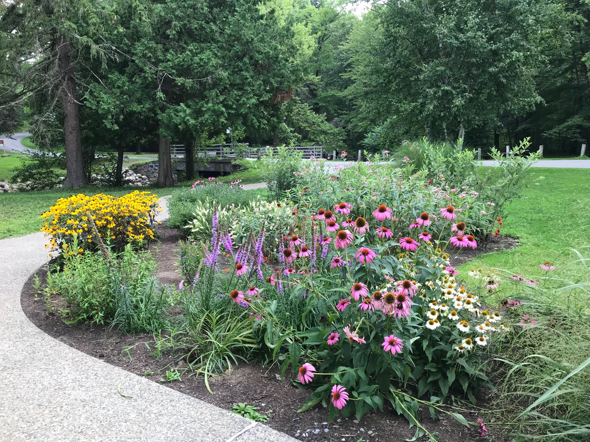
Rain garden at the Creekside Classroom at Saratoga Spa State Park. Coneflowers, blazing star, black eyed Susan’s, swamp milkweed, summersweet, winterberry and more are planted in this rain garden!
If you want to learn more about rain gardens, check out these great step by step how-to manuals that are available for free online
A 1920s postcard showing the original ladder on the Indian Ladder Trail.
John Boyd Thacher State Park will be hosting a Centennial Celebration on Saturday, September 13th from 10am to 7pm. This free event will feature a variety of fun things to do, including live birds of prey, guided hikes to Tory and Hailes Caves, live music from Oobleck and Hair of the Dog, and kids’ activities including horse-drawn wagon rides, bouncy castles, a climbing wall and pony rides, along with outdoor workshops from L.L. Bean. A ceremony will be held at Thacher Point at 11:00am as at the original dedication 100 years ago.
On September 14th, 1914, Emma Treadwell Thacher joined Governor Martin Glynn and over 1,000 other attendees to formally dedicate 350 acres of the Helderberg Escarpment in memory of her late husband, John Boyd Thacher. Since that day, John Boyd Thacher State Park has expanded to cover over 2400 acres with 25 miles of hiking trails and 9 picnic pavilions to be enjoyed by the public. Please join us on September 13th as we celebrate our history and look forward to the next century of John Boyd Thacher State Park.
There’s a new critter at the Moreau Lakes Nature Center in Saratoga County – Daryle the eastern box turtle!
For now, Daryle is staying behind the scenes as he gets used to his new home and lifestyle, but this summer he will star in educational programming out of the Nature Center.
Box turtles are named for the special, hinged plastron that allow these turtles to close their shell almost completely. Box turtles live in open woodlands, pastures, and marshy meadows. They are often found near streams and ponds, where they like to enter the shallow water (although they are not aquatic).
Daryle found his way to Moreau Lakes through Mid-Atlantic Turtle and Tortoise Society (MATTS). MATTS is dedicated to protecting habitat for turtles and tortoises and educating the public on proper care for pet turtles and tortoises.
Daryle was attacked by a dog, and his subsequent injuries meant that he would never be able to close up his shell again. He would not have been able to survive in the wild, and so he was relocated to the nature center. However, Daryle won’t be lonely at Moreau – another turtle from MATTS rescue is already resident at the nature center. Berlin, the painted turtle, was an abandoned pet who has also found a new home at Moreau Lakes.
The painted turtle is one of the most common turtle species in North America. In fact, it’s the only turtle that naturally occurs across the whole continent. They are often seen basking in groups on logs in the water and along the shore. They are omnivores, dining on plants, slugs, snails, insects, algae, as well as carrion and small fish.
Painted turtles and box turtles are cute, but don’t take one home! Capturing native NY species as pets is illegal. Fortunately, the Moreau Lakes Nature Center has educated, caring staff that will make sure these unreleasable turtles live in comfort the rest of their days.
Photos by Rebecca Mullins, Moreau Lake State Park. Post by Paris Harper