Get Outdoors and Get Together Day 2025 is in the books! On the second Saturday of June each year, select state parks and public lands hold Get Outdoors and Get Together Day to bring outdoor recreation to people with disabilities, and to encourage the entire community to spend a day together in the outdoors. Visitors enjoyed music, crafts, and educational programs, and tried out adaptive recreational equipment.
Trying out Chenango Valley State Park’s new Action Trail chair and posing with the iconic Get Outdoors and Get Together Day frame.
New York State Parks is dedicated to making sure that visitors of all abilities can enjoy our parks and historic sites. In 2023, a record 84.1 million visitors came to our properties, so it is more vital than ever to ensure that all who visit have a safe and fun experience!
“Every individual has a different set of abilities, a different set of strengths, and a wealth of experience and wisdom that comes with them.
As in ecological communities, our social communities and lives are enriched by having a diverse array of problem solvers, friends, and loved ones.
We at Rockefeller [State Park] are excited to welcome people who have traditionally been excluded from outdoor spaces, knowing that the more perspectives and voices are on our public land, the closer we are to cultivating sustainable relationships to our natural world and to one another.”
-Devyani Mishra, Conservation Steward at Rockefeller State Park Preserve
A wheelchair user plays the metallophone on The Autism Nature Trail at Letchworth State Park.
For many of us, getting to our favorite state park isn’t as easy as packing some snacks and jumping in a vehicle to spend a beautiful day in nature. Transportation to parks located in rural and off the beaten path locations where public transportation doesn’t service can be a challenge. And even if the park is in an urban setting, it may not always be accessible either.
That is why NY State Parks in the Niagara Region are partnering with Erie County, the NYS Department of Environmental Conservation, and Niagara Frontier Transportation Authority (NFTA) to kick off the second season of the Parks Adventure Bus! The program launched in the summer of 2022, offering riders (1) FREE transportation to and from a number of Buffalo-area parks as well as (2) FREE entry to those parks.
How it works:
On Saturdays from June to early August, NFTA-METRO buses depart from and return to the Metropolitan Transportation Center in Buffalo throughout the day. The Parks Adventure Bus is free and park entry is free to riders. Please arrive 10 minutes to board all buses downtown and at all parks. Bike racks are available, but are first-come, first-served.
To get more information about what to bring and what to know before you go, have a look at our Parks Adventure Bus brochure.
Scheduleand Trip Times:
June 17: Knox Farm State Park
June 24: Chestnut Ridge Park
July 1: Reinstein Woods and Como Lake Park (enjoy one or both)
July 8: Fort Niagara State Park
July 15: Emery County Park
July 22: Beaver Island State Park
July 29: Akron Falls State Park
August 5: Evangola State Park
If any of the days are cancelled due to weather, August 12 is reserved as a make-up day.Two trips in September and one in December are also available. Learn more here.
Buses depart from the Metropolitan Transportation Center at 8:30 AM, 10:15 AM, 11:30 PM, 1:15 PM, and 3:15 PM.
Buses departfrom the park destination (to return to the Metropolitan Transportation Center) at 11:10 AM, 12:20 PM, 2:10 PM, 4:05 PM, and 6:00 PM.
PAL Trip Times:
Using the same dates above, Parks Adventure Bus service to and from each park will be provided on PAL for eligible riders.
Reservations are available to arrive at the parks at 9:00 AM, 10:45 AM, 12:00 PM, 1:45 PM, and 3:45 PM.
PAL vehicles departfrom park destinations at 11:10 AM, 12:20 PM, 2:10 PM, 4:05 PM, and 6:00 PM.
For people with differing levels of physical ability, it can be difficult to know in advance whether a hiking trail might be too steep, too narrow, too soft, or otherwise not suitable.
Here at State Parks, we are working to help address that through something called the Universal Trail Assessment Process (UTAP). Developed in the 1990s by a Nevada-based company specializing in aiding differently abled people to engage in recreation, UTAP is a system of objective measurements taken at specific intervals along an unpaved trail to form an accurate picture of its difficulty, in terms of grade, width, surface firmness and cover.
UTAP is the creation of Beneficial Designs, whose founder Peter Axelson suffered a spinal injury in the mid-1970s. Axelson later went on to become a championship alpine adaptive skier and founded his company to design and fabricate adaptive recreational equipment for people with mobility impairments. The company also develops accessibility standards for ski areas, amusement parks, playgrounds and other outdoor recreation environments.
Parks is entering our third year of the UTAP program, having measured more than 19 miles of trails at 17 different State Parks in 2019 and 2020. It is a time consuming process done on foot with several hand tools, with measurements taken at least every 100 feet. That has meant nearly 1,200 individual measurement points have been recorded so far!
So if any hikers encounter Parks staff carrying a clinometer (a protractor-like device used to measure grade), a hand-held roller wheel (used to measure distance), a level, and a hand-held GPS unit (used to record locations), they have seen the UTAP process in action.
The trail measuring tools under the Universal Trail Assessment Program.(Photo credit – Beneficial Design)
Student Conservation Association member Tyler Stempsey measures trail accessibility at the Olana State Historic Site. (Photo credit – NYS Parks)
This year, a new wheeled “buggy” is being acquired by State Parks that will carry a laptop computer to make measurement recording faster. With the buggy, an entire mile of trail can be measured in about an hour, a big improvement over doing everything manually.
This work is being supported by a Recreational Trail Program (RTP) grant from 2019, with the project currently scheduled to run through 2022.
These thousands of measurements are meant to identify which Parks trails meet what is called Recreational Trail Accessibility Standards (RTAS), which State Parks adopted from the United States Access Board standards and United States Forest Service standards Trail Accessibility Guidelines. These standards set requirements for maximum trail steepness, width, surfaces, passing space, resting areas, trailheads, gates, and signage.
With such measurements, Parks will be able to publicize trails that already comply with RTAS and prioritize trail improvement projects that would increase trail compliance with RTAS.
A sample is shown here of how measurements and surface conditions developed through UTAP can be represented visually. This shows a steep pitch across a trail, called a cross slope, that results in a soft, damp trail surface with mud, a situation which would render that trail out of compliance with the RTAS requirements.
So far, trails identified as meeting these standards include the Upper Falls Lookout Trail at Letchworth State Park and the Awosting Falls Connector Trail at Minnewaska State Park Preserve.
There are also several trails that are close to meeting RTAS with minor modifications including: the Bog Trail at Chenango Valley State Park, the Beacon Hill Trail at Minnewaska State Park, the Bike Path at Schodack Island State Park, and the Green Lakes and Round Lakes Trail at Green Lakes State Park.
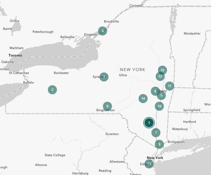
This map shows trails in State Park showing where UTAP measurements have been made. (Photo Credit – NYS Parks)
Work is currently under way to improve the Green Lakes trails (park is #3 on the map above) so it meets standards.
More information on the UTAP assessment process and standards specific to State Parks and the trails examined so far, as well as an interactive version the above map, can be found here.
Once the measurement data is compiled and finalized, Parks will be able to provide a listing of accessible trails, as well as focus future improvement efforts on trails close to meeting accessibility standards.
The data we are collecting will also allow Parks to create detailed trail access information signs, which would provide visitors at trailheads with vital information such as slope, surface cover, distance, clearance, and elevation gains.
An example of a trail sign based on measurements of grade and cross slope taken under the UTAP system. (Photo Credit – Beneficial Designs)
The goal of the UTAP program is to make Parks trails more inclusive to all, regardless of ability. If you have a favorite trail that could be assessed for accessibility, let us know in the comments!
Cover Shot – Parks staffer Sean Heaton assesses trails at Minekill State Park in Schoharie County. (Photo Credit – NYS Parks)
Post by Victoria Roberts, GIS/Accessible Trails Technician, NYS Parks