Fall fungi comes in a wide range of appearances, often in striking shapes and colors. Due to the moist air of autumn in New York State, our parks and trails abound with opportunities to see them in all their uniqueness. Many of them have fantastically creepy names or appearances, just in time for the spookiest time of year.
Read on to meet some eerie and funky fall fungi to search for on your fall hikes and walks!
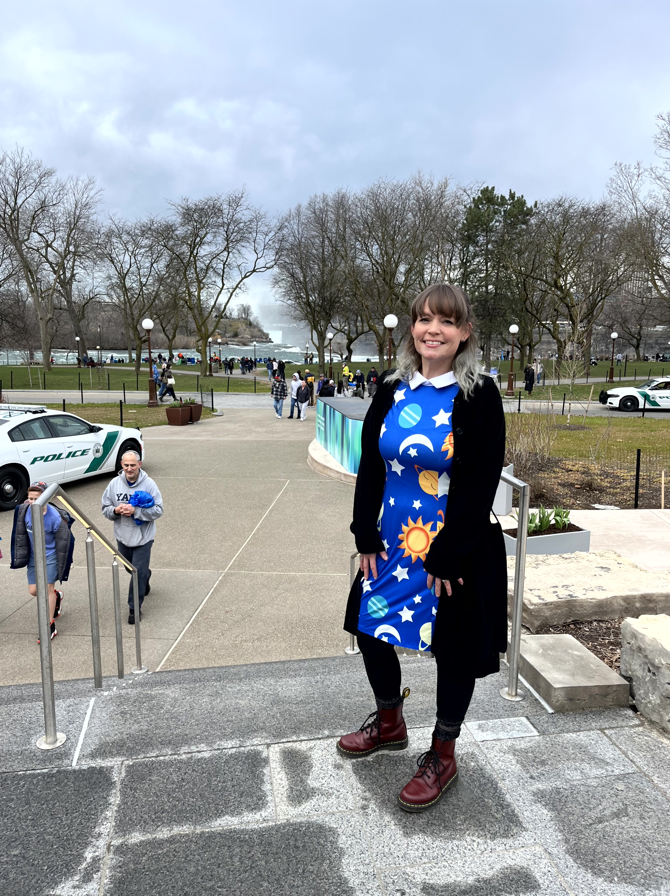
On April 8, New York State Parks and Historic Sites welcomed people from around the world to share a once-in-a-generation total solar eclipse. Thousands of people enjoyed a rich, memorable experience thanks to the hard work of our staff over a two-year period.
Public Information Officer Angela Berti of the Niagara Region led this effort on behalf of State Parks and represented our agency on the statewide Eclipse Task Force.
Our Park Police used their expertise in peacefully managing large crowds to keep our visitors safe. Countless staff worked behind the scenes and on the front lines to open selected campgrounds for the occasion, plan educational programming, get the word out to the public, make sure our parks were in top condition, and ensure the safety of our visitors.
As Chief of Staff and Commissioner Pro Tempore, I am filled with pride and gratitude for all the hard work of our staff in preparing for this remarkable event. Enjoy reliving the day with photos from around our parks and sites!
For many of us, getting to our favorite state park isn’t as easy as packing some snacks and jumping in a vehicle to spend a beautiful day in nature. Transportation to parks located in rural and off the beaten path locations where public transportation doesn’t service can be a challenge. And even if the park is in an urban setting, it may not always be accessible either.
That is why NY State Parks in the Niagara Region are partnering with Erie County, the NYS Department of Environmental Conservation, and Niagara Frontier Transportation Authority (NFTA) to kick off the second season of the Parks Adventure Bus! The program launched in the summer of 2022, offering riders (1) FREE transportation to and from a number of Buffalo-area parks as well as (2) FREE entry to those parks.
How it works:
On Saturdays from June to early August, NFTA-METRO buses depart from and return to the Metropolitan Transportation Center in Buffalo throughout the day. The Parks Adventure Bus is free and park entry is free to riders. Please arrive 10 minutes to board all buses downtown and at all parks. Bike racks are available, but are first-come, first-served.
To get more information about what to bring and what to know before you go, have a look at our Parks Adventure Bus brochure.
Scheduleand Trip Times:
June 17: Knox Farm State Park
June 24: Chestnut Ridge Park
July 1: Reinstein Woods and Como Lake Park (enjoy one or both)
July 8: Fort Niagara State Park
July 15: Emery County Park
July 22: Beaver Island State Park
July 29: Akron Falls State Park
August 5: Evangola State Park
If any of the days are cancelled due to weather, August 12 is reserved as a make-up day.Two trips in September and one in December are also available. Learn more here.
Buses depart from the Metropolitan Transportation Center at 8:30 AM, 10:15 AM, 11:30 PM, 1:15 PM, and 3:15 PM.
Buses departfrom the park destination (to return to the Metropolitan Transportation Center) at 11:10 AM, 12:20 PM, 2:10 PM, 4:05 PM, and 6:00 PM.
PAL Trip Times:
Using the same dates above, Parks Adventure Bus service to and from each park will be provided on PAL for eligible riders.
Reservations are available to arrive at the parks at 9:00 AM, 10:45 AM, 12:00 PM, 1:45 PM, and 3:45 PM.
PAL vehicles departfrom park destinations at 11:10 AM, 12:20 PM, 2:10 PM, 4:05 PM, and 6:00 PM.
Home of the awe-inspiring and world famous Niagara Falls, this region stretches from the shores of Lake Ontario to the shores of Lake Erie, encompassing sand dunes and waterfalls, old growth forests and reclaimed agricultural lands, grasslands and gorges, urban and rural greenspaces, rivers and wetlands.
Covering Niagara and Erie counties, this diverse region includes 18 parks, two historic sites, and many miles of hiking trails, as well as several Bird Conservation Areas, an Internationally Significant Important Bird Area, and a Ramsar designation for the Niagara River as a wetland of global significance.
To start, any successful hike starts with a good map. Maps for hiking trails and a variety of other useful information on State Parks, including those in the Niagara region and other regions, are now available on the NYS Parks Explorer app. The free app, which is available for use on Android and iOS devices, is easy to download, user friendly and allows patrons to have park information readily available every State Parks facility across the state.
Trail maps are also available on each individual park website page at parks.ny.gov and at the main office of each park. Links to maps are also included in the trail descriptions in this post. Be sure to download maps ahead of time to your phone or tablet, and maybe even carry a paper copy as a back up to aid your hike.
As with all hikes, there are a few things to remember beyond carrying a mobile phone. Check the weather forecast before you go, and dress appropriately. Wear sturdy, yet comfortable shoes or boots, bring enough water and snacks, and perhaps carry a camera to capture what you see. Be mindful of wildlife and give it appropriate space, particularly in areas marked as protected, such as for shorebird nesting.
Always be aware of your surroundings and mindful of hikes on steep terrain or those that go near cliff tops. Having a small first-aid kit available in case of an emergency is never a bad idea.
Hiking poles are also useful on longer hikes and can transfer some of the stress of hiking from your knees and legs to your arms and back.
Hikers should plan their route in advance, know how long a trail is and how long it ought to take to finish. If weather conditions change for the worse, be prepared to turn back. Don’t let a desire to reach a specific destination make you press on. Since daylight is not an unlimited resource, even in summer when days are longer, tossing a flashlight or headlamp into your backpack is a good form of insurance, should you unexpectedly find yourself on the trail as dusk approaches.
State Park facilities are carry-in, carry-out, so don’t leave trash behind. Follow Leave No Trace principles to keep trails clean for everyone.
Additionally, as incidents of tick-borne diseases surge in the state, it is always important to check yourself for ticks after being outside, even if it is only time spent in your own backyard.
Lastly, as the COVID-19 pandemic continues, remember to practice safe social distancing, particularly in parking lots and at trailheads, and use face coverings when a distance of six feet cannot be maintained, even if you have been vaccinated. To learn more about important COVID safety guidelines, click HERE.
Erie County
Buffalo Harbor State Park, 1111 Fuhrmann Blvd., Buffalo, (716) 822-1207 – The only state park in the city of Buffalo, this park is located within Buffalo’s Outer Harbor area and covers about 190 acres on the shoreline of Lake Erie. It has a nautical themed playground for the kids and slips for up to 1,000 boats.
The Shoreline Trail along the waterfront is a multi-use trail for walkers, runners, cyclists, and people of all ages and abilities. Visitors can enjoy the brisk breeze coming off the lake on a hot summer day while watching kites and gulls soar high above, see the sailboats, kayaks, and motorboats gliding across the waves, and witness stunning sunsets.
This trail is particularly important for its connection to a larger trail system. The Shoreline Trail connects all the way through Niagara Falls to Fort Niagara State Park, and also links to the Empire State Trail, the 750-mile trail from Buffalo east to Albany and New York City, and north to the Champlain Valley and Adirondacks.
The Gateway to the trails at Buffalo Harbor allows access to a larger trail network, including the new Empire State Trail. The park’s trails are paved to provide universal access to those of differing abilities. (Photo courtesy of Niagara Region Interpretive Office)
Evangola State Park, 10191 Old Lake Shore Road, Irving, (716) 549-1802 – Located 24 miles west of Buffalo, this Lake Erie shoreline park has more than five miles of trails within its 733 acres of forest, marsh, meadows and vernal pools.
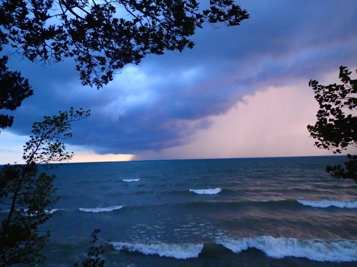
Starting behind the Evangola Nature Center, the half-mile Rim Trail traverses high bluffs with picturesque views of Lake Erie. During summer, trail hikers experience a leafy canopy overhead and a moss green carpet trailside, while enjoying cooling lake breezes and the the sound of waves crashing far below. Belted-Kingfishers, Bald Eagles and a variety of gulls can often be spotted soaring above the water here.
During the winter, the park’s plentiful lake-effect snow provides cross-country skiers and snowshoers with a chance to glimpse unique ice formations and spot artic ducks found here seasonally. The trail is a place to watch a sunset, catch a cool breeze or see the power of a storm rolling in across the lake.
A storm blows in from across the lake as seen from the Rim Trail, while below, in winter shoreline vegetation and ice for intricate formations. (Photos courtesy of Niagara Regional Interpretive Office)
Knox Farm State Park, 437 Buffalo Road, East Aurora, (716) 652-0786 – Covering 633 acres, this park is the former country estate of Seymour H. Knox, a Buffalo businessman who co-founded the F. W. Woolworth stores. He purchased the property in 1890s to train standardbreds and carriage horses. Primarily grasslands that are home to a variety of grassland bird species, the site includes some woodlots and wetlands.
The park contains about seven miles of trails, including the Library Trail, which is reached directly from the parking lot. It leads into a field active in summer ith bobolinks, a grassland bird related to blackbirds and orioles. From there, the trails leads to a small woodlot with towering sugar maple trees and a small library in the woods.
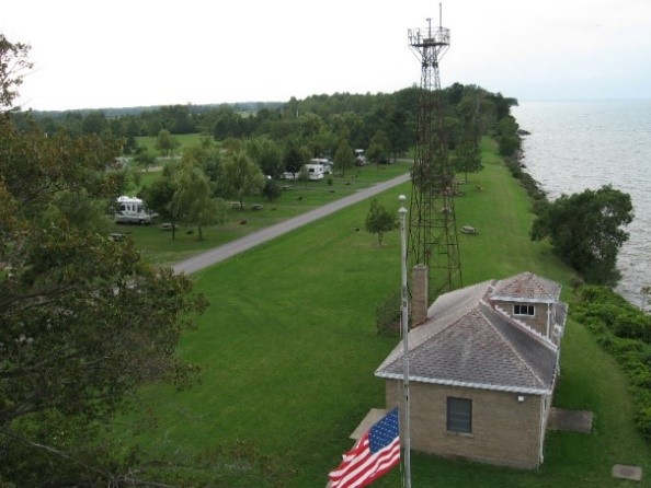
Golden Hill State Park, 9691 Lower Lake Road, Barker, (716) 795-3885 – This park contains Thirty Mile Point Lighthouse, built in 1875 to warn ships of a rocky shoal and shifting sandbar in Lake Ontario. There were several shipwrecks in the vicinity; the most famous being the HMS Ontario, a British warship that sank Halloween night in 1780. An active light until 1958, today the upstairs cottage is rented year-round and the foghorn building is now a visitors’ center with displays on the lighthouse and local maritime history.
There are three trails at Golden Hill, with the likely favorite being the scenic Red Trail which travels along the lakeshore and leads to Golden Hill Creek. Along the creek is an oak grove with trees up to 300 years old. Bald eagles are known to frequent this area, as well as great blue herons and wintering waterfowl. After crossing the creek on the footbridge, the trail branches off – east to the marina or west along the creek with stands of apple, beech and hop hornbeam trees.
The Red Trail travels along the lakeshore for continuing inland along Golden Hill Creek. (Photo Courtesy of Niagara Region Interpretive Office)
Wilson Tuscarora State Park, 9691 Lower Lake Road, Barker, (716) 795-3885 – Established in 1965, the park on Lake Ontario encompasses 476 acres bordered by the east and west branches of Twelve Mile Creek. It has approximately seven miles of trails.
Nestled along the east branch of Twelve Mile Creek is the one-mile Interpretive Trail, which moves through several habitats, including wetlands, successional fields (a field transitioning to a forest), shrub lands, and ending in a mature beech-hemlock forest. This trail is best known for its spring wildflowers – notably white trillium, New York’s largest flowered trillium – that appear on the forest floor in May.
White trillium are found on the forest floor starting in May. (Photo courtesy of Niagara Region Interpretive Office)
The Interpretive Trail along Twelve Mile Creek, where pileated woodpeckers can be spotted. (Photo courtesy of Niagara Region Interpretive Office)
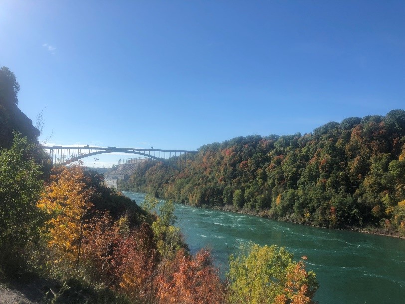
Earl W. Brydges Artpark State Park, 450 South 4th Street, Lewiston, (716) 754-7766 – Founded to promote the visual and performing arts, this park is on the lower Niagara River below the world famous falls. It contains two trails that are a part of the Niagara Gorge Trail System.
Trail 7, also called the Artpark Gorge Trail, takes a path through the Niagara Gorge, providing views of the Lewiston-Queenston Bridge, the New York Power Authority, and the vibrant blue green waters swirling in the lower Niagara River. Along this trail are seen fossils from the era of the Silurian Sea, before the time of the dinosaurs. After a climb around boulders and a waterfall view, a set of stairs leads down to the river’s edge to Trail 8, which is popular with fishermen who seek the river’s salmon or lake trout.
A view of the Lewiston-Queenstown Bridge from Trail 7 in Artpark. Below, a New York Power Authority hydropower plant is visible from the trail. (Photos courtesy of Niagara Regional Interpretive Office)
If the stairs are not taken, the trail traverses a shale slide and woods before emerging in a flourishing grassland ecosystem that connects to Trail 2 heading toward Devils Hole State Park.
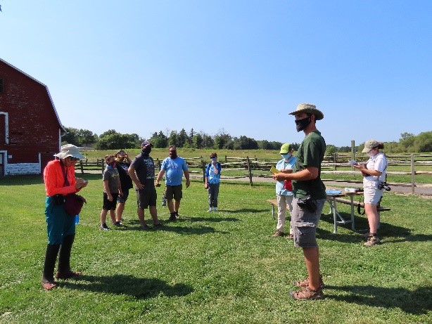
What is a BioBlitz? When I hear that word, images of scientists in white lab coats running madly about flash through my mind. Our first ever BioBlitz at Knox Farm State Park, while not so chaotic, certainly had people dashing about.
Unlike my visions, it was not a cadre of sprinting scientists in lab coats, but rather a gathering of researchers and volunteers clad in hiking boots, cargo pants and sun hats. With magnifiers and nets in hand, cameras and binoculars strung around their necks, these 32 intrepid investigators were ready to spread out. Their mission? Find and document as many living species as possible in the park – and do it in just two days
Participants gather for the BioBlitz at Knox Farm State Park. (Photo Credit – Claudia Rosen)
If this sounds like a hefty undertaking, it is. With 633 acres of grasslands, woods and wetlands, Knox is a large area to adequately survey in a short time. However, that is part of the fun of a BioBlitz. Since the word “blitz” is the German word for lightning, this event is about speed as well as efficiency.
These high-energy events are designed to bring together biologists, conservationists, hikers, naturalists, park goers and nature enthusiasts alike, so anyone can get involved. No expertise required… This is an opportunity to learn, explore and share all the incredible species that call our parks home. The best part is, when people spread out to tackle a larger area, the chances are better that someone will find something completely unexpected.
A view of the grasslands at Knox Farm.The team assigned to identify plant species goes to work. (Photo Credit – Claudia Rosen)
The stage set, so began the first ever Knox Farm State Park BioBlitz on the sunny weekend of August 22-23. Six field teams, each led by an expert, went on a search to survey targeted taxa such as birds, mammals, reptiles/amphibians, plants, invertebrates, and fungi. Guided hikes were led for each field team so participants could learn and share from other team members. BioBlitzers also had the option to tackle an assigned territory alone to help cover more of the park.
Eyes on the sky as the bird survey team identifies their targets. (Photo Credit – Claudia Rosen)
A light is used on a sheet to attract moths to be surveyed. (Photo Credit – Claudia Rosen)
With keen eyes, the group found and documented more than 400 species! This was well above the expected number given the tight deadline. In total, our community scientists recorded 179 species of plants, 164 invertebrate species, 49 species of fungi and lichen, 39 species of birds, six species of mammals, five reptile and amphibian species, and two species of fish.
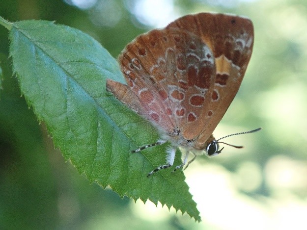
One highlight was the discovery of a new species of butterfly for the park, the Harvester. An uncommon species, the Harvester butterfly has the distinction of having the only carnivorous caterpillar in NorthAmerica, feeding on the woolly aphids of beech and alder trees, making it a great discovery indeed.
The Harvester butterfly, which has the only carnivorous caterpillar species in North America.
The data gathered during our BioBlitz will be incorporated in our Parks biota databases, which can be used for determining park conservation and management decisions.
For those interested in learning more about the BioBlitz, check out the Knox Farm State Park BioBlitz event page and explore all of the incredible discoveries for yourself. Don’t forget, while this BioBlitz was an organized group event, you can have your own personal BioBlitz whenever and wherever you’d like. You can even have a BioBlitz in your own backyard! This is a great way to learn about local nature and discover the incredible diversity we have in our own neighborhoods.
Remember, before surveying any land you do not own, be sure to contact the landowner for permission, and make sure to have any necessary permits needed to collect specimens. Many bioblitzes rely solely on photographic records, and having smart phone or tablet can make record-keeping easier. At Knox Farm, we used the iNaturalist app.
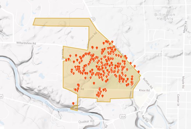
This map shows the species sightings recorded by the BioBlitz at Knox Farm State Park.
For more information on having your own BioBlitz, check out this 10 steps to BioBlitz guide.
For those interested in learning more about Knox Farm State Park, which is located about 20 miles southeast of Buffalo in Erie county, there are year-round guided hikes are offered through the Niagara Region Interpretive Programs Office. To help find your way around on your own, click HERE for a map.
See you at the next BioBlitz!
Cover Shot- BioBlitz participants practice COVID safety protocols.
Post by Matthew Nusstein, Environmental Educator – Niagara Region of New York State Parks
Learn about previous BioBlitzes at New York State Parks…
On May 3, 2014, over a hundred volunteers with scientific backgrounds gathered at Minnewaska State Park Preserve in Ulster County and Clark Reservation State Park in Onondaga county for two concurrent Bioblitzes, 24-hour inventories of the park’s biodiversity. Our objectives were to search the park for as many rare species and natural communities in the…
1 Park 70 professional scientific volunteers 365 acres Countless plants and animals Well, maybe not countless… In fact, on May 3rd and 4th nearly 70 volunteers with scientific backgrounds gathered at Clark Reservation State Park with one goal in mind: spend 24 hours searching for all the plants, animals, fungi, lichen, and even bacteria found…