Created in partnership with the Ralph C. Wilson, Jr. Foundation in 2021, New York State Parks’ Ladders to the Outdoors program launched with a goal to have children from underserved communities experience the outdoors at state parks in Erie and Niagara counties. Building upon the success of the Connect Kids to Parks program, which reimburses transportation costs for field trips, Ladders to the Outdoors staff members work closely with teachers and community leaders to plan visits and provide the equipment needed to create successful experiences.
Since the program’s inception, organizers have taken kids out on trail walks, fishing trips, bike rides, and to visit the New York State Fair. The program’s core mission “to connect kids to their New York State parks and historical sites, outdoor recreation, nature, and foster a lifelong love of the outdoors” remains the same today as it did at the outset, but now also features some welcome and expanded ambitions.
A group sporting Ladders to the Outdoors backpacks explores the New York State Fair.
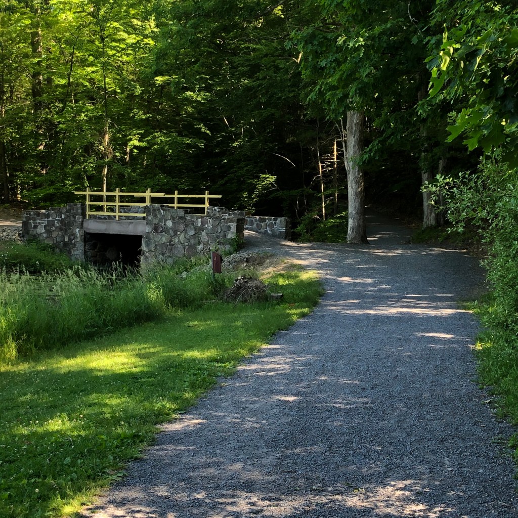
With summer now in full swing, hiking trails are calling from the Central Region of State Parks, which stretches from Lake Ontario to the Southern Tier and Pennsylvania border.
The region includes glacial lakes, sandy beaches, segments of the historic Erie Canal, and dramatic waterfalls.
Covering Broome, Chenango, Cortland, Delaware, Herkimer, Madison, Oneida, Onondaga, Oswego and Otsego counties, the Central Region is home to 22 parks, seven historic sites and three golf courses.
Overview of State Parks and Historic Sites in the Central Region.
Maps and a variety of other useful information on NY State Parks, including those in the Central Region, are now available on the NYS Parks Explorer app. The free app, which is available for use on Android and iOS devices, is easy to download, user friendly and allows patrons to have park information readily available.
As with all hikes, there are a few things to remember beyond carrying a mobile phone. Wear sturdy, yet comfortable shoes or boots, bring water and snacks, and perhaps carry a camera to capture what you see. Be aware of your surroundings and mindful of hikes on steep terrain or those that go near cliff tops. Having a small first-aid kit available in case of an emergency is never a bad idea.
Hiking poles are also useful and can transfer some of the stress of hiking from your knees and legs to your arms and back.
Trail maps are available on the new Parks Explorer app, as well as on each individual park website page at parks.ny.gov and at the main office of each park. Be sure to download maps ahead of time or carry a paper copy as a back up
In addition to the name and distance of each designated trail in a park, the maps include facilities such as parking, comfort stations, park offices, nature centers, campsites, and boat launches. To learn more about NYS Parks trails CLICK HERE.
Hikers should know how long a trail is and how long it ought to take to finish. Since daylight is not an unlimited resource, tossing a flashlight or headlamp into your backpack is a good form of insurance, should you unexpectedly find yourself on the trail as dusk approaches.
Additionally, as incidents of tick-borne diseases surge in the state, it is always important to check yourself for ticks after being outside, even if it is only time spent in your own backyard.
Lastly, as the COVID-19 pandemic continues, remember to practice safe social distancing, particularly in parking lots and at trailheads, and use face coverings when a distance of six feet cannot be maintained. To learn more about important COVID safety guidelines, CLICK HERE.
Chenango County
Oquaga Creek State Park, 5995 County Route 20 Bainbridge, NY 13733, (607) 467-4160: Take a scenic hike around beautiful 55-acre Artic Lake on a trail perfect for all ages, including beginning hikers. Afterward, cool off by taking a swim or having a picnic at the beach. The trail starts at the right side of the beach area, where the main Oquaga Creek is tucked in the woods. After coming out of the woods, take the blue trail to the left to start a 1.2-mile journey around the lake. There are plenty of spots to stop and fish and even a cemetery dating back to the Civil War. The park has more than ten miles of wooded and open trails.
Chenango Valley State Park, 153 State Park Road, Chenango Forks, (607) 648-5251: The two-mile Chenango Lake Trail circles the park’s namesake lake. The trail on the eastern side is open, accessible, and suitable for wheelchairs, while the western side is more robust single-track style path. There are several ways to start the trail – at the newly renovated beach area, located at the south end of the lake, or after parking in the new ADA compliant parking lot at the north end of the lake that connect to the Bog Trail, which then connects to the lake trail.. This multi-use trail also attracts dog walkers, hikers, cyclists, and bird watchers. And keep an eye out for one of the park’s resident bald eagles, gliding above the lake searching for a meal. This park has more than 14 miles of trails.
To explore the park’s 14 miles of trails, find a trail map here…
The ADA-accessible trail at Chenango Valley State Park.
Onondaga County
Green Lakes State Park, 7900 Green Lakes Road, Fayetteville, (315) 637-6111: This 2,200-acre park has a nearly 20 miles of trails, with access starting at the main parking lot at Green Lake, a rare meromictic lake with an unique aqua color. (Meromictic lakes have water layers that do not annually intermix, as in in the case with nearly all other lakes. There are only three dozen meromictic lakes in the U.S. Green Lakes has two, with Round Lake being the second.) Trails around both Green Lake and Round Lake run about three miles, while doing just the Green Lake trail covers two miles. The park offers a variety of recreation including mountain biking, fishing, kayaking, and birdwatching.
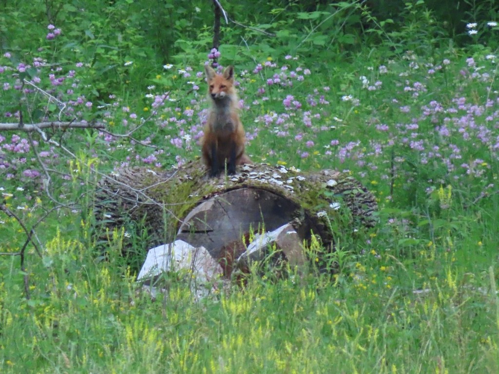
Delta Lake State Park, 8797 State Route 46, Rome, (315) 337-4670: This park is located on a peninsula that juts into the Delta Lake Reservoir. The Fox Run Trail starts in the northwest corner of the Fox Run Parking lot. At about a half-mile long, this wide level trail is perfect for beginners. With benches along the way to rest and take in the surroundings, hikers can see a variety of ducks, the occasional eagle, a rare owl and maybe even a fox. The Fox Run trail ends at the Yellow trail, where you can keep exploring the shoreline forest or head back.
A red fox surveys from atop a downed tree stump at Delta Lake State Park.
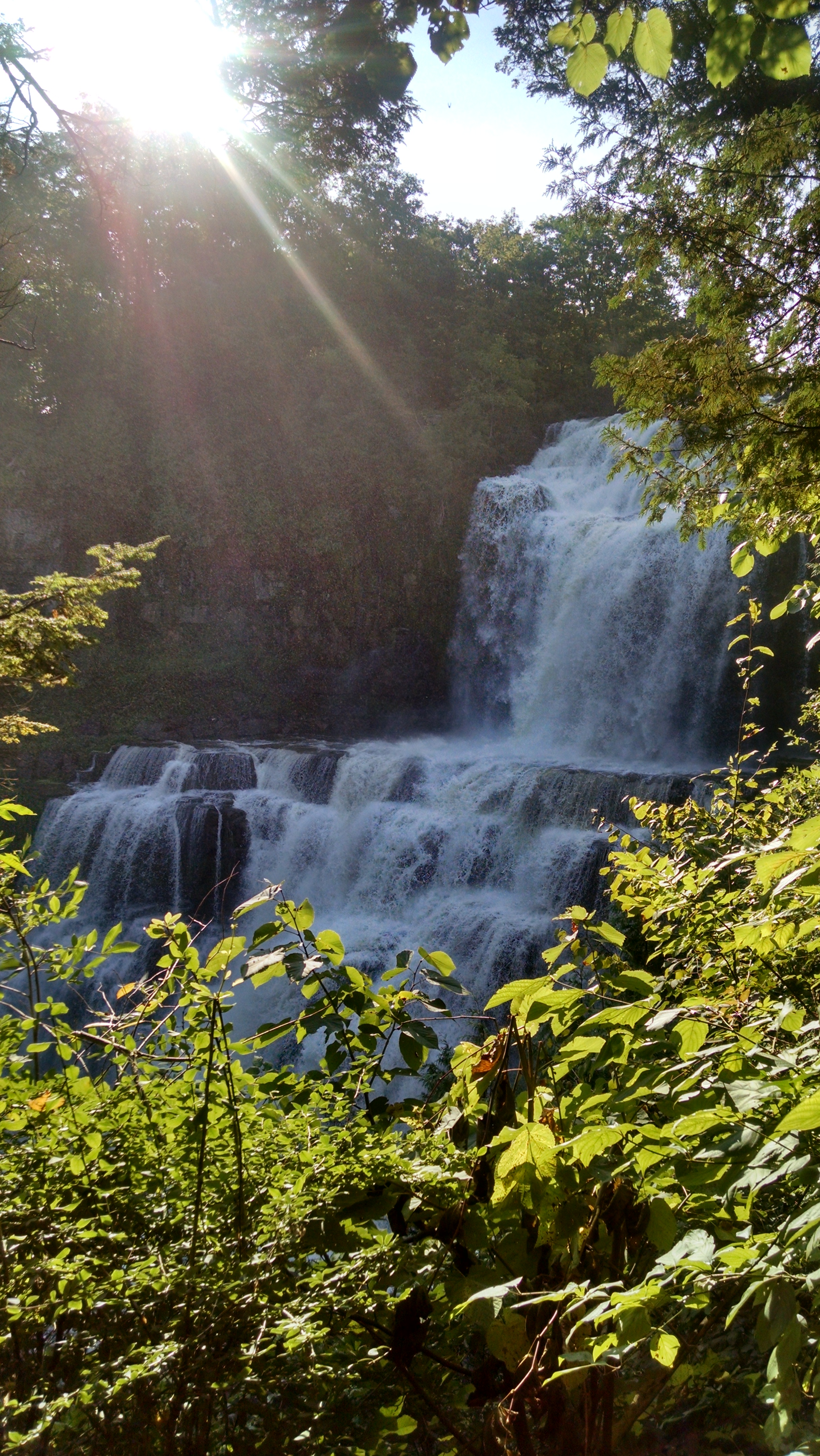
Pixley Falls State Park, 11430 State Route 46, Boonville, (315) 337-4670: A highlight of the Nature Trail, which is just three-quarters of a mile long, is the 50-foot waterfall that the park is named for. The trail can be steep, and slippery in wet weather, so proper footwear is definitely recommended. The trail includes many other smaller falls, and on its lower half follows the course of the Lansing Kill, which is well known for its trout fishing.
Glimmerglass State Park, 1527 County Highway 31, Cooperstown, NY 13326, (607) 547-8662: Overlooking Otsego Lake, the famed “Glimmerglass” of James Fenimore Cooper’s Leatherstocking Tales, this park offers five miles of hiking trails and a beach for swimming afterward.
The rolling, partially wooded terrain is host to a wide variety of wildlife. If you bring your four-legged friend, remember to keep dogs on a six-foot leash at all times.
An uphill trail through Mount Wellington offers the Sleeping Lion Trail that varies terrain and offers two miles of varying terrain for a moderate hike. Along the service road that leads to the trail head offers an scenic overlook of the lake to the south toward Cooperstown.
The overlook of Otsego Lake at the Sleeping Lion Trail.
The Beaver Pond trail offers a half-mile ADA -accessible trail surface around the “Beaver Trail”. Along this route you will discover “Eco Boxes” that describe the animals that might been seen during a hike.
The Covered Bridge Trail leads to the oldest wooden covered bridge in the United States. This one-mile, partially wooded trail runs along along Shadow Brook that feeds Otsego Lake.
The wooden covered bridge at Glimmerglass State Park.
Betty and Wilbur Davis State Park, 133 Davis Road, Westford, NY 12197, (607) 547-8662: Perched atop of a hill, this 223-acre park offers spectacular views and vistas to the south and west for some amazing sunsets.
This park has 2.7 miles of trails, with gentle meadows, wooded areas, and two catch and release ponds. Birdwatchers, remember to bring your binoculars.
As the summer months wind down, the FORCES Program staff of the Central and Finger Lakes Regions are busy both reflecting on the last few months and making plans for the next academic year.
FORCES stands for “Friends of Recreation, Conservation and Environmental Stewardship”, and the FORCES Program specifically focuses on building long-term, mutually beneficial partnerships between local state parks and colleges. Currently this includes one-day volunteer events, FORCES clubs at six colleges, dozens of stewards between the two regions, partnerships with faculty members and college administration, projects in over twenty parks and historic sites, and involvement with fourteen colleges and universities within the Finger Lakes and Central Regions.
This summer has been an exciting one, with the “FORCES family” including 37 stewards and seasonal employees! The FORCES interns and seasonal employees started together in June with the first annual “Trainapalooza,” which was held this year at Robert H. Treman State Park in the Finger Lakes Region. The stewards gathered for a two day training on invasive species identification and removals, iMap Invasives training, an overview of the geologic and human histories of the area, interesting features of some of the parks, and strategies for outreach and interpretation. The group also camped overnight at the park, and got to know each other while playing Frisbee, solving riddles, and enjoying s’mores.
The first annual FORCES Trainapalooza. Photo by FORCES Visual Media Steward Michael Gill (Cazenovia College).
FORCES stewards Morgan Nivison (Le Moyne College) and Haixu Zhao (SUNY ESF) remove garlic mustard at Green Lakes State Park. Photo by FORCES Visual Media Steward Michael Gill (Cazenovia College).
FORCES stewards Maggie Terry (SUNY ESF) and Jake Barney (Ithaca College) pull water chestnut at Fair Haven Beach State Park. Photo by Becky Sibner.
FORCES staff and stewards prepare for a Chittenango Ovate Amber Snail survey.
After they were trained, the stewards separated again to begin projects throughout the two regions. Many projects focused on invasive species removal; stewards worked to remove water chestnut, pale swallowwort, slender false brome, and many other species of invasive plants. Other projects included the creation of a video about the FORCES program, historical research, assistance with the ongoing surveys for the Chittenango Ovate Amber Snail at Chittenango Falls State Park, water quality monitoring at Selkirk Shores State Park, and trail blazing at Two Rivers State Park… the list goes on and on!
The upcoming academic year will bring more excitement as FORCES welcomes new and returning stewards and club members. The semester started with the New York State Fair, where FORCES annually engages the public in building bluebird boxes- they assembled 1,250 boxes just this year! To date, FORCES at the State Fair has hosted over 180 students and involved 8 colleges. Plans are also in motion for the first annual FORCES Membership Gathering, which will take place in October and combine trainings with celebrations for club members, stewards, seasonal staff, and ambassadors- all members of the “FORCES family”.
In the spring, FORCES will hold its second annual Leadership Summit, which assembles club officers and FORCES “Ambassadors” from all FORCES schools to plan and strategize for the growth of the FORCES Program. The event was a huge success last April, with the FORCES staff being (again) blown away and inspired by the passion and dedication of the students.
Keep an eye out for FORCES stewards as you visit the parks, and chat with them about the projects they are working on. They’re accomplishing big things!
The chits are well camouflaged for living in the leaf litter, by C. Gilbertson
Try watching a snail! No seriously, it’s quite calming. They glide along and seemingly know exactly where they are going. They are curious, and if you listen really carefully, you may hear them munching away when they eat!
Cody Gilbertson, a Master’s student of conservation biology at SUNY-ESF, has been working with and watching snails since 2010. On top of that, the species she works with is a small land snail that is also one of the most endangered species of New York. This little snail is quite famous because it is only found at one location in the entire world!
Not a bad field site! By P. Harper
The Chittenango Ovate amber snail resides at Chittenango Falls State Park. At the base of a waterfall 167 feet in height, this unique species goes about its business amongst rocky ledges and lush vegetation. This summer, teams of volunteers signed up to help Gilbertson assess the size of the snail population and contribute data for her research.
In these snail surveys, volunteers survey small plots of snail habitat for a set amount of time, capturing small snails in tupperware containers as they go. After the collection, all the captured snails are sorted an identified, so we can figure out which are Chittenango Ovate Amber Snails (affectionately called “Chits”) and which are other snail species. After the count, the Chits are released back where they were found and the other snails are removed.
The team scrambles over rocks! By P. Harper
The data from these surveys is part of Gilbertson’s greater study on the life cycle of this rare snail and figuring out what is necessary for their survival. What do they eat? What conditions do they need to survive? How the heck do they live through upstate New York winters? She is looking for new methods to increase this snail’s overall numbers with a goal to help stabilize their population and create a template for other conservation efforts for land snail species.
This baby snail was born in captivity, and may provide clues to how we can protect the endangered chits. By C. Gilbertson
Another important aspect of the project is captive breeding. So far, Gilbertson has successfully bred a biologically similar snail species and yielded roughly 3000 hatchlings. She is also looking at how many other snail species live in isolated populations within New York State to find out if isolated populations are common or rare in this family of snails.
Not many people slow down to examine the small beings on earth. Some animals may almost be invisible, but they all play a big part in ecosystems and the small size of the animal does not make them less important. So next time you’re feeling rushed in life, take a moment to watch a snail, you’d be amazed at the calm steady creature before you!
Featured image is of Chittenango Falls at Chittenango Falls State Park, by Paris Harper.
Skunk cabbages grow in the damp peat at the shady, forested edge of the bog.
NYS Parks often has to perform a balancing act between meeting the needs of the wildlife and environments, and providing the opportunities for recreation that sometimes negatively impact ecosystems, but also allow people to experience nature and buoy the public interest in maintaining and protecting our parks.
Mud Lake, at Robert V. Riddell (RVR) State Park in Delaware County, is a good example of such a place. The NY Natural Heritage program (NYNHP) completed a vegetation map based on field surveys at Robert V. Riddell State Park, and has documented one rare insect species and a high quality dwarf shrub bog, both at Mud Lake. Mud Lake is a very scenic feature in the park, but as park use increases, this fragile ecosystem faces greater risks. For this reason, the Office of Parks, Recreation and Historic Preservation (OPRHP) is looking to provide better visitor access to Mud Lake while protecting the fragile bog and pond habitat.
Given that RVR has only recently been designated a state park, there has been relatively little development beyond trail surveys and invasive species removal. Because the park is so close to Hartwick College, one of the most important uses of the park is for education and research, which only adds to the importance of protecting a rare and high-quality ecosystem like Mud Lake. Hartwick College has been a long time partner of State Parks and continues to utilize Robert V. Riddell State Park for educational opportunities.
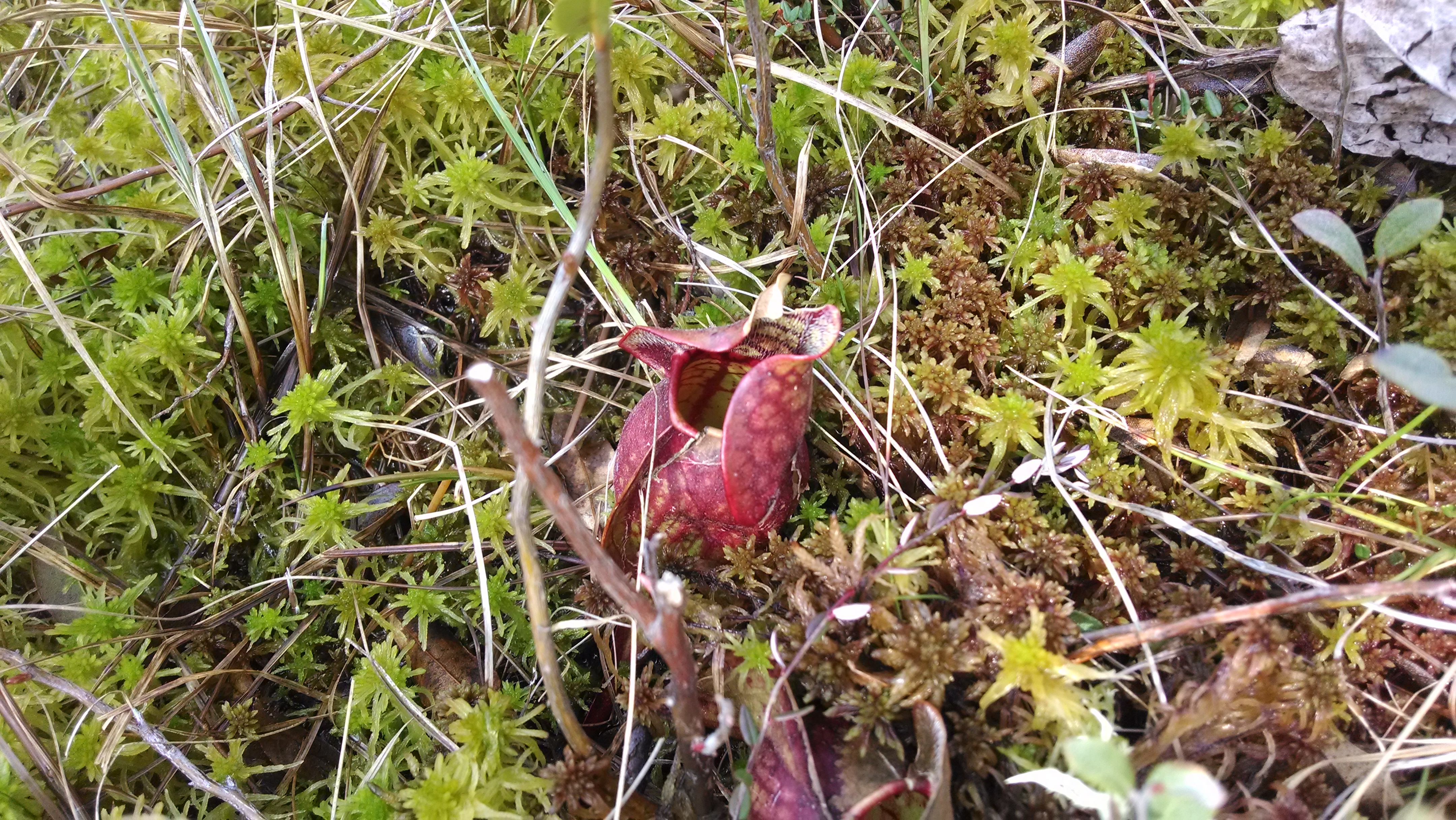
Mud Lake is located on the parcel of land recently acquired from Hartwick College. It’s a small, spring-fed pond surrounded by forest and circled by a narrow band of spruce and tamarack trees, transitioning to low shrubs, and finally to a floating mat of sphagnum peat at the edge of the open water. This type of ecosystem is called a dwarf shrub bog, and it is a particularly fragile environment. Wild cranberries only grow in dwarf shrub bogs, as do carnivorous pitcher plants and sundews. These plants can be found growing out of the peat moss.
Pitcher plants grow out of peat moss, which is lower in nutrients than regular soil. Pitcher plants capture and digest insects to make up for this!
The peat is strong enough to walk on, but the water flowing through the thick vegetative mat gives you the feeling of standing on a waterbed – I was afraid of falling through!
The peat will hold you up, but not without getting your shoes wet!
Visitor access to Mud Lake is challenging. Currently, there is no defined pathway that can take you from the edge of the forest out to the open pond and bog area. This means any park visitors that want to get a closer look are making their own paths through the edge of the bog, and putting fragile plants at risk of being crushed.
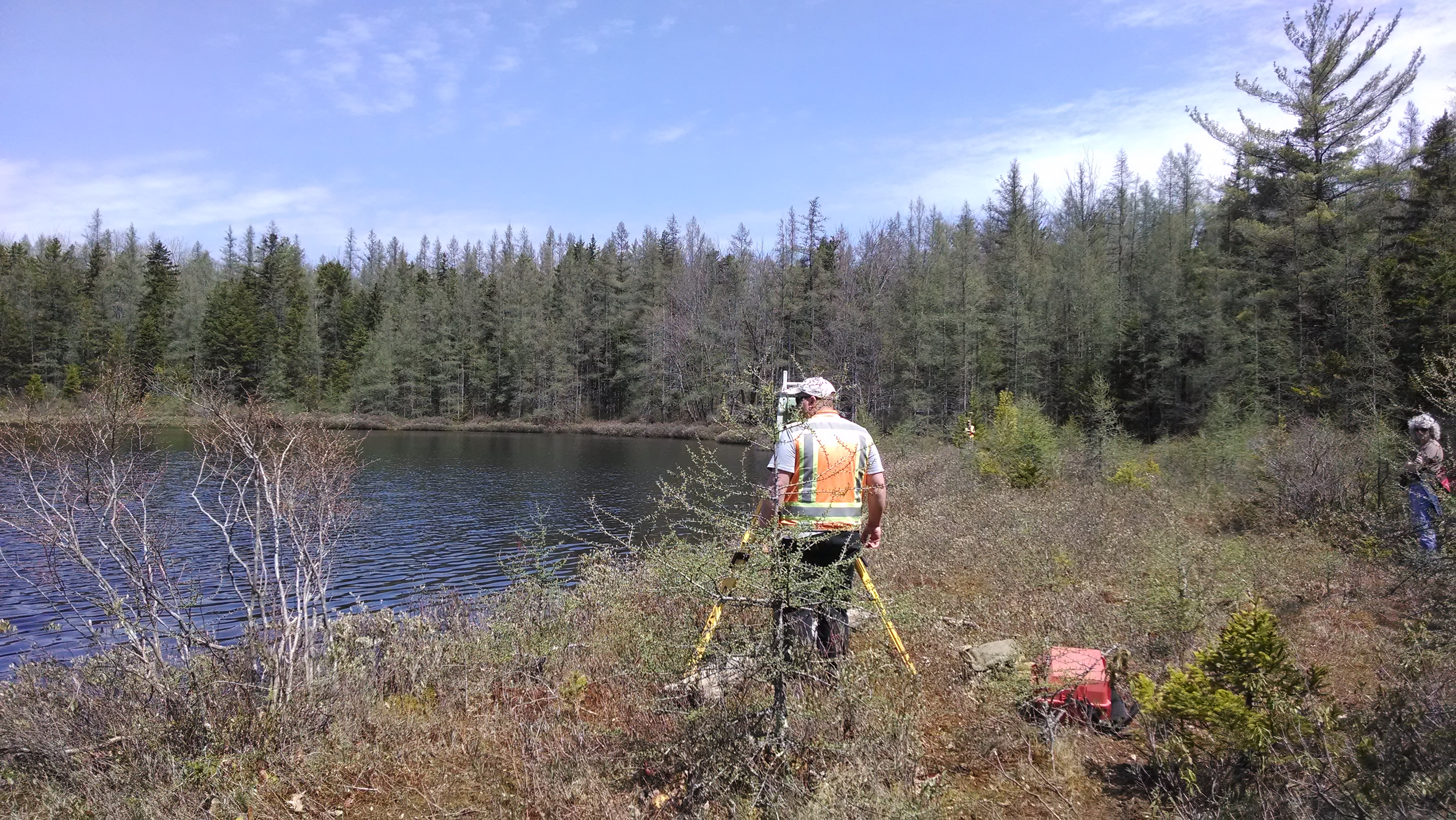
To protect Mud Lake and also to enhance visitor experiences, OPRHP is in the process of designing a boardwalk from the upland edge of the bog to the water’s edge, including a gathering space where groups of students and other visitors can be brought to view the bog. However, building a solid structure on a bog presents unique challenges. Last winter, core samples taken from the peat went as far as 27 feet deep and still did not hit hard earth. At the tree line, solid ground was 20 feet below the surface of the soft, damp peat layer. OPRHP is still working on resolving all the construction challenges in this project, but we are hard at work to protect Mud Lake.
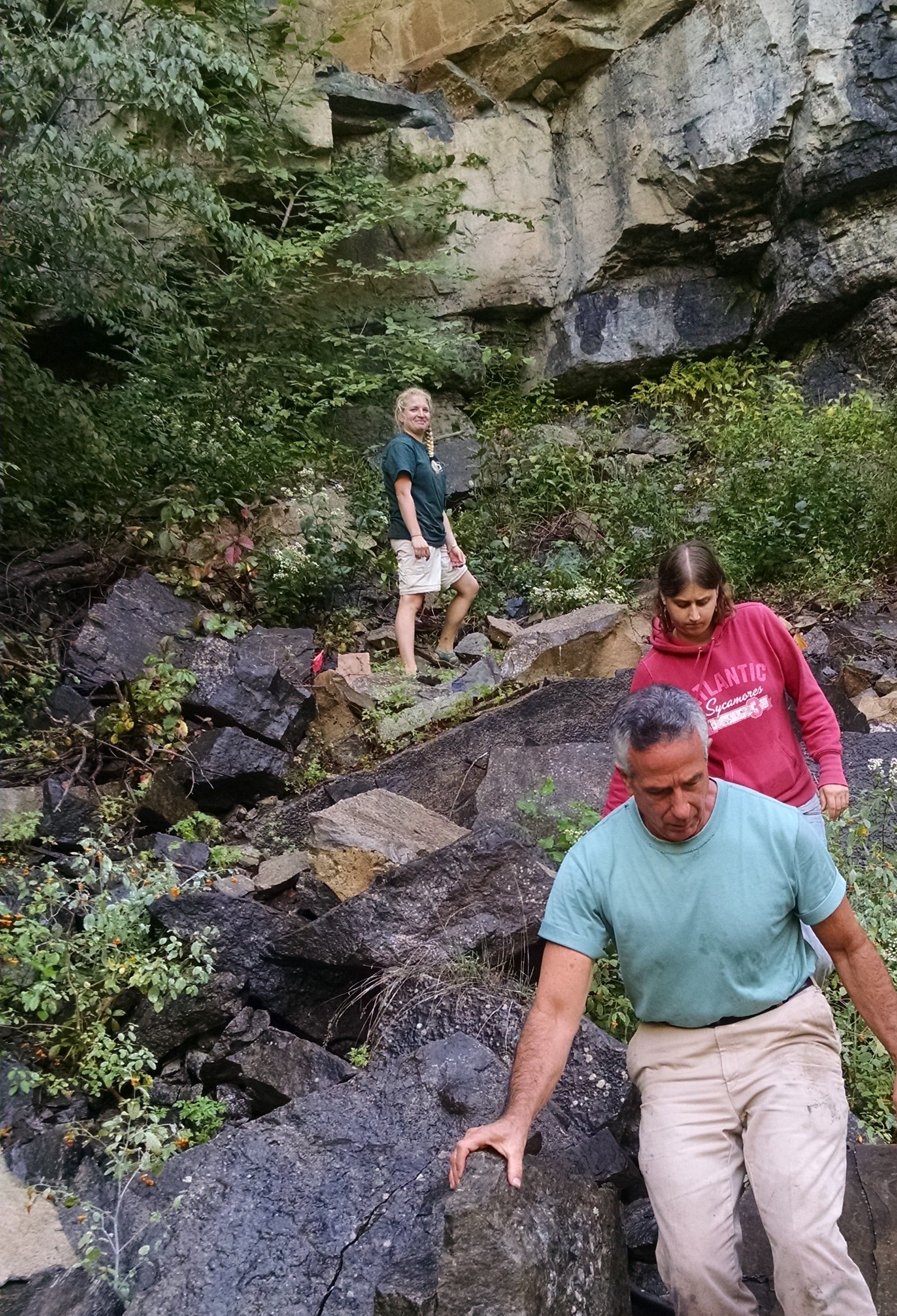
Surveyors at work on Mud Lake
featured image is of Mud Lake in early May. Post and photos by Paris Harper


")
 and Haixu Zhao (SUNY ESF) remove garlic mustard at Green Lakes State Park")
 and Jake Barney (Ithaca College) pull water chestnut at Fair Haven Beach State Park. Photo by Becky Sibner")
.")