Tag Archives: Gorges

The Untold Origin Story of the Falls

AuntSarahsFalls
Aunt Sarah’s Falls, just south of Watkins Glen State Park

Over the last 12,000 years, the landscape of the Finger Lakes region has undergone colossal change. Hidden in cracks and valleys throughout the region are wondrous geologic remnants of that change. So abundant is the splendor of these wonders that many locals have become numb to the consistent gurgling of waterfalls on their daily commute through, for example, the Village of Montour Falls, just south of Watkins Glen State Park, where residents often pass Aunt Sarah’s Falls on Route 14. Yet no two of the over 2,000 gorges that call the Finger Lakes home are the same; each has a different fingerprint with a different number of curves, caverns, and cascades.

The Finger Lakes themselves are a unique natural phenomenon. There are no other lakes quite like them in the world. Eleven north flowing lakes, varying in length and depth, span over 120 miles of the western section of New York. They range from Canadice Lake, at a mere 3 miles long, to Cayuga Lake, which stretches for 38.2 miles; and from the relatively shallow Honeoye Lake, at 30 feet deep to Seneca Lake, which plunges steeply for 634 feet.

FingerLakesMapWikimedia
Map of the Finger Lakes, accessed from commons.wikimedia.org/wiki/Atlas_of_New_York

About 2.5 million years ago dawned the age of ice. In this region, glaciers are thought to have been over 3,000 feet high, or about the size of two Empire State buildings stacked on top of each other! It is a result of these glaciers growing that we now have “finger lakes”; before we had “finger rivers.” All our U shaped lake basins were originally V shaped river valleys. As the glaciers bulldozed their way through the valleys, the unrelenting force gouged out the walls. About 12,000 years ago, a change in climate warmed the earth, ending the reign of the Ice Age.

WatkinsGlen

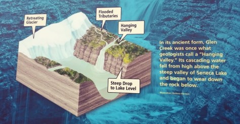
As the glaciers started to recede, their melting ice filled the lakes and exposed steep U shaped valley walls. All around would have been hanging valleys comprised of massive waterfalls dropping straight into the lakes. Today, every gorge near the lakes, including those south of the lakes, began its story as one of those waterfalls and has since eroded back into the rock.

“Ithaca is Gorges” is an iconic phrase in Ithaca, referring to the numerous gorgeous gorges around this city at the base of Cayuga Lake. This clever pun, however, has a forgotten key third part. As the massive waterfalls started to erode back into the rock, the eroded sediment built up at the base of the lake. This erosion was so rapid that our lakes are miles shorter than they were originally. “Ithaca is Gorges” because it was formed by the gorges and would not exist without them!

Devonian
Devonian Sea was found in western and central New York

The extremely fast rate of erosion in our gorges alludes to its rich ancient natural history dating back long before the Ice Age. The 380-million-year-old layers of rock in the gorge were each once the bottom of an expansive inland ocean that covered much of the eastern states. The earth, as we know it, was unrecognizable; life was just beginning to take a foothold on land. In the little town of Gilboa, NY, proof of this timeframe can be found in the oldest fossilized trees worldwide. The early roots of these Gilboa trees were pioneering the rocky, unforgiving earth on the edge of the Devonian sea.

This tropical inland sea – which was at that time located below the equator – was the result of a collision between the North American and European continents. When they collided, North America subducted, or went under Europe, and Europe crinkled up creating the Acadian Mountain range just off the coast of New York. These impressive mountains were estimated to have been as big, if not bigger, than the Himalayas are today!

WatkinsGlen1
Evidence of the Devonian Sea can be seen at Watkins Glen State Park

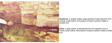
Much of the sediment found in the inland sea would have come from the erosion of these mountains, but the depth of this water would have, over time, also affected the type of sediment found on this ocean bottom. Gradually, the buildup of layers would have caused enough pressure to solidify the underlying sediment into rock. This is known as compaction. This means that every layer of rock in our gorges, be it the more brittle rocks, such as shale, or the denser rocks, such as sandstone and limestone, were once at the bottom of an ocean!

SandstoneShale

The layers however are only half of the puzzle influencing the speed of erosion in the gorge. Breaking up the layers, in a stunning display of natural masonry, are countless straight line fractures. There are fractures or joints that follow the gorges east to west and those that span across the gorge north to south, intersecting at almost perfect right angles. Notice the unnatural looking straight lines and right angles in the photo of Robert H. Treman State Park.

WatkinsGlen2
Looking up the creek at Robert Treman State Park

These joints date back about 300 million years. At this time, all the continents were joining together to form one enormous supercontinent.  Pangea, which translates directly to “all earth,” stretched from pole to pole. If you study a map of the world’s continents, you may notice that the western edge of Africa matches up with the eastern edge of the United States like a jig saw puzzle. The stress of this collision alone, however, was not the force required to create the fractures.

Instead, it caused straight line weak points in the rock perpendicular to the pressure. Meanwhile, a batch of methane gas had matured under pressure and heat and took advantage of the weak points to escape from the depths of earth. After this event, 30 million years quietly passed while Africa unassumingly rotated around North America. This quiet rotation was disturbed 270 million years ago when another batch of methane gas matured under heat and pressure, again utilizing the weakened rock to escape. The timing of this second release just so happened to occur when Africa was at about a 90 degree angle from where the first batch of methane gas escaped, forming joints that meet up at almost perfect right angles. Next time you find yourself in the Finger Lakes, keep an eye out for these natural right angles, they’re everywhere!

TaughannockBoth
Taughannock Falls amphitheater has thousands of joints that contributed to the bowl shape
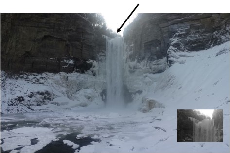
The top of the falls has two joints intersecting at a right angle.

Considering all 380 million years of the gorges’ rich natural history;

  • the glaciers that created the U-shaped lakes and the hanging valleys
  • the joints that resulted from the release of methane gas through the weakened rock
  • and the layers of rock – shale, sandstone, and limestone, remnants of an ancient inland sea
  • an ingenious combination of forces all working together to form the gorges in only 12,000 years comes to light. In short, as the water easily erodes away the brittle shale and undercuts itself, the joints or fractures that break up the creek bed speed up the erosion process by causing chunks of the denser rocks – sandstone and limestone to fall at a time. The water, therefore, never has to take the time to erode away the denser types of rock. In consequence, we can affectionately say that “Although our gorges are 12,000 years old, their story can be told in no less than 380 million years.”

Post by Tamara Beal, Finger Lakes 2018 Student Conservation Association Intern

First Saturday Hikes in the Finger Lakes Region

Each year in the Finger Lakes ten hikes are offered throughout the region on the first Saturday of each month.  Hikes are led by Parks staff or Parks interns and are offered at different locations each month and vary in length (3-5 miles) and difficulty.   As leaders, we try to keep everyone together during the hikes as much as possible but with group size ranging from 2-50, variable terrain and different fitness levels we sometimes get spread out until we take a rest and regroup.   We encourage everyone to attend, including but not limited to families, seasoned hikers, visitors to the region, locals, groups, clubs, well behaved dogs and anyone else you can think of. There is no First Saturday hike in January because of the January 1st  First Day Hike on offered at Taughannock Falls State Park and no hike in May due to I Love My Park Day always falling on the first Saturday of May.

RTreman_Gary Cremeens
Jane Suhey from the 2017 First Saturday Educational Hike at Robert H. Treman State Park, photo courtesy of Gary Cremeens

The idea behind these hikes is to get people out exploring new parks and learning more about hiking parks while getting a little exercise.  Each hike is unique because there are sometimes different leaders and the mix of people who attend is always varied.  Both of factors shape how the hike unfolds.  We routinely discuss park history, geology, natural history, hiking basics and anything else that is relevant or sometimes topics that come from left field! Last month the temperature was in the low 40’s and there was a steady rain so we began with a discussion on hypothermia and how to tell if someone might be hypothermic.

CatherineValley_J Teeter
October 6th hike along the compact stone-dust Catherine Valley Trail (quick side trip to see Montour Falls)

The origin of this offering of hikes is linked to the 2014 First Day Hike when I first met Gary and Wendy Cremeens. After hiking five miles with me they said that they had such a good time that we should do it every month.  Their positive energy and willingness to help and support everyone around them sold me on the idea. We offered our inaugural First Saturday Hike at Buttermilk Falls State Park in February of 2015.  Gary is in the Cubs outfit in the photo below; he is usually wearing something fluorescent, almost always in shorts and when he attends, he runs around distributing the hike schedule, offering bug spray or tissues and welcomes everyone who shows up. Wendy is equally supportive and always acts as the hike sweeper so no one gets left behind.

ButtermilkFallsHikers_Wendy Cremeens
Aug 4th 2018 hike at Buttermilk Falls State Park, photo courtesy of Wendy Cremeens

Hikes are free (certain parks at certain times of year charge a parking fee) and reservations are not required but will be accepted via my email at josh.teeter@parks.ny.gov.  If you have questions about the hike location, difficulty or any other related questions, feel free to email me in advance.  The calendar of hikes can be found on the New York State Parks calendar or on Facebook by searching First Saturday Educational Hikes.

Post by Josh Teeter, State Parks

The Petaltail’s Tale

Each June and July, visitors to several gorge parks are rewarded with an unusual treat – the chance to see a “living fossil.”

The term “living fossil” refers to species that have evolved very little over the course of millions of years. Some well-known examples of living fossils include elephant sharks, ginkgo trees, and horseshoe crabs. Although all of these organisms have evolved, these species have stayed so similar that fossils from millions of years ago are still recognizable as ancestors to the modern species.

Petaltail on Rocks, photo by State Parks
A gray petaltail perches in the sun along a gorge trail, photo by State Parks.

Meet the gray petaltail dragonfly (Tachopteryx thoreyi), a species of dragonfly that closely resembles its ancestors who were around when dinosaurs roamed the earth during the Jurassic Period – almost 200 million years ago!  During that time, the petaltail dragonfly was part of very widespread family known as the Petaluridae. Today, however, there are only 11 species of Petaluridae remaining worldwide.

The gray petaltail is found in several of the Finger Lakes gorge parks the gray petaltails love hunting in the gorges, because they can go to the sunny side of the gorge to get warm, which allows them to move much faster.  Petaltails are drawn to the gorges to lay their eggs in the soggy seeps on wooded slopes. Most dragonflies lay their eggs in water bodies. The eggs grow into juvenile dragonflies, called nymphs that also typically live in water.  That is not the case for the gray petaltail nymphs! The gray petaltail is the only species of dragonfly that does not have fully aquatic nymphs. Instead, the petaltail nymphs live and grow while hidden in the mud, moss and moist leaf litter in the forest seeps. As the nymphs mature, they climb up the trunks of trees to become the adult dragonflies that can fly fast and free all around the gorge.

Dragonfly nymphs - Wikimedia
Petaltail nymphs look very similar to these aquatic dragonfly nymphs, photo by 2109tristan https://commons.wikimedia.org/wiki/File:Dragonfly_nymphs_2013-06-20_16-36.jpg

While they are not nearly as large as their Jurassic ancestors, today’s petaltails are one of the larger species of dragonflies, with a wingspan of up to 5 inches wide.  Their distinct black and gray coloring also makes it easy to identify.  This species often perches upon rocks and tree trunks, but it is not uncommon for it to perch upon a passerby! Although they are large and ferocious insect predators (eating thousands of mosquitoes), dragonflies are harmless to humans. If you are lucky enough to be chosen as a dragonfly perch, you may be startled, but either brush them away very gently or just enjoy it!

Petaltail caught during odonate survey, Becky Sibner
Gray petaltail caught during an odonate (dragonfly) survey, photo by Becky Sibner, State Parks.

The gray petaltail is listed as a species of special concern within New York State, as it is only known in specialized habitat in a small number of locations.  NY Natural Heritage Program (NYNHP) continues to survey for them and recently found another new site for them. Luckily, some of those locations are within New York’s state parks, providing habitat protection to this fascinating species – and maybe a chance to see this primitive insect for yourself, especially in June and July.

Petaltail_habitat_Lundgren_NYNHP
Look for gray petaltails in habitats  like this, photo by Julie Lundgren, NY Natural Heritage Program

Post by Laura Young, FORCES Environmental Education Steward & Becky Sibner, Stewardship Project Coordinator, State Parks

Featured image: gray petaltail on a Jack-in-the-pulpit, Kerry Wixted

Sources:

Paulson, D. (2011). Dragonflies and damselflies of the East. Princeton, N.J: Princeton University Press.

NY Natural Heritage Conservation Guide for gray petaltail

Gray petaltail, IUCN 2017. The IUCN Red List of Threatened Species. Version 2017-1. <http://www.iucnredlist.org>. Downloaded on 12 May 2017.

Dragonflies – living fossils

Email correspondence with Jason J. Dombroskie, Ph.D. Manager, Cornell University Insect Collection (CUIC) & Coordinator of the Insect Diagnostic Lab (IDL)

Celebrate Your Freedom In a State Park!

Fourth of July weekend is a great weekend to spend in a State Park or Historic Site.  You can build sand castles at Hither Hills State Park to camp on the banks of Lake Erie at Evangola State Park, fish in the St. Lawrence River at Wellesley Island State Park, listen to a reading of the Declaration of Independence at Stony Point Battlefield State Historic Site, take a hike, enjoy the forest and more.  Find out all that State Parks has to offer this weekend at nysparks.com.

Thacher Indian Laddler Trail near Falls
Take a hike on the Indian Ladder Trail at Thacher State Park, Photo by OPRHP
Stony Point-3002
Hear the cannons firing at Stony Point Battlefield State Historic Site, photo by OPRHP
Spider Fishing
Try your hand at fishing at Wellesley Island State Park, photo by OPRHP
schuyler
Play one of George Washington’s favorite games at Schuyler Mansion State Historic Site, photo by Schuyler Mansion State Historic Site
Lorenzo
Tour the gardens at Lorenzo State Historic House, photo by OPRHP
John Jay kids in pen with Rabbits and Chickens
Check out the Farm Market at John Jay Homestead State Historic Site, photo by OPRHP
Gorge
Enjoy a cool gorge in the Finger Lakes Parks or at Whetstone Gulf State Park – photo by OPRHP
John Williams
Build a sand castle at Hither Hills State Park, photo by John Williams, OPRHP
Glimmerglass State Park summer 2008
Picnic by the lake, Glimmerglass State Park, photo by OPRHP
Boy Salamander
Get to know the residents, salamander program at Allegany State Park, photo by Tom LeBlanc OPRHP
Rockland Lake Golf DSC_9783
Try your hand at golfing at Rockland Lake State Park, photo by OPRHP
Grafton Bike event_2267 copy
Go biking at Grafton Lakes State Park, photo by OPRHP
Cherry Plain Camping_AAT0238 web
Camp at Cherry Plain State Park, photo by OPRHP
Finger Lakes Boating
Go boating in the Finger Lakes, Allan H. Treman State Park, photo by OPRHP
Trees
Marvel at old-growth trees in Allegany State Park along the Conservation or Eastwood Meadows Trails – photo of old-growth ash tree in Allegany State Park by J Lundgren, NYNHP
Fireworks_PRT0033
See the fireworks at many parks across the state, photo by OPRHP
Sunset, Golden Hill
Or enjoy a quiet evening sunset, Golden Hill State Park, photo by OPRHP