

Spring season is photo season! Whether you’re capturing prom or graduation photos, scouting locations for wedding photos, thinking ahead to your Christmas cards, or just looking to refresh your social feeds, it’s the perfect time of year to get out there with your camera or cell phone. Read on for location inspiration in various categories—truly one-of-a-kind locations, waterfalls, iconic New York visuals, design-focused areas, and more!—and get professional photography tips from our State Parks photographer and videographer.
Continue reading Shoot Like a Pro at Parks and Historic Sites’ Most Instagrammable SpotsTag Archives: waterfalls

Waterfalls Herald Spring’s arrival
So much has changed in recent days as all of us in New York deal with the COVID-19 pandemic, But natural cycles are still continuing to mark the arrival of spring.
One of those cycles is the freshet – a term used to describe a thaw from snow and ice melt that then feeds a surge of fresh water into rivers and streams. Too large a freshet can cause spring flooding.
While much of the snow in New York is now gone, there is still snowpack remaining in the high country from the recent storm that will feed the freshet in the coming days. And while that surge is thankfully too small to cause flooding, it does mean that is a great time to see some of the beautiful waterfalls found in New York State Parks.
Use this map to locate a State Park with a waterfall.
In the eastern North America, annual freshets occur from the Canadian Taiga ranging along both sides of the Great Lakes, continuing through the heavily forested Appalachian mountain chain and St. Lawrence valley from northern Maine into barrier ranges in North Carolina and Tennessee.
In the western part of the continent, freshets occur throughout higher elevations of various west coast mountain ranges that extend southward down from Alaska as far as the northern reaches of Arizona and New Mexico.
This previous post from the NYS Parks Blog describes each waterfall in detail:

Fall in Love with New York State Parks’ Waterfalls
Did you know that Niagara Falls State Park is the oldest state park in the United States? Established in 1885 as Niagara Reservation, the breath-taking waterfalls at this park are considered some of America’s greatest natural wonders. Did you also know that the American Falls at Niagara Falls State Park, at around 100 feet tall,…
By Brian Nearing, Deputy Public Information Officer, New York State Parks.

The Untold Origin Story of the Falls

Over the last 12,000 years, the landscape of the Finger Lakes region has undergone colossal change. Hidden in cracks and valleys throughout the region are wondrous geologic remnants of that change. So abundant is the splendor of these wonders that many locals have become numb to the consistent gurgling of waterfalls on their daily commute through, for example, the Village of Montour Falls, just south of Watkins Glen State Park, where residents often pass Aunt Sarah’s Falls on Route 14. Yet no two of the over 2,000 gorges that call the Finger Lakes home are the same; each has a different fingerprint with a different number of curves, caverns, and cascades.
The Finger Lakes themselves are a unique natural phenomenon. There are no other lakes quite like them in the world. Eleven north flowing lakes, varying in length and depth, span over 120 miles of the western section of New York. They range from Canadice Lake, at a mere 3 miles long, to Cayuga Lake, which stretches for 38.2 miles; and from the relatively shallow Honeoye Lake, at 30 feet deep to Seneca Lake, which plunges steeply for 634 feet.

About 2.5 million years ago dawned the age of ice. In this region, glaciers are thought to have been over 3,000 feet high, or about the size of two Empire State buildings stacked on top of each other! It is a result of these glaciers growing that we now have “finger lakes”; before we had “finger rivers.” All our U shaped lake basins were originally V shaped river valleys. As the glaciers bulldozed their way through the valleys, the unrelenting force gouged out the walls. About 12,000 years ago, a change in climate warmed the earth, ending the reign of the Ice Age.

As the glaciers started to recede, their melting ice filled the lakes and exposed steep U shaped valley walls. All around would have been hanging valleys comprised of massive waterfalls dropping straight into the lakes. Today, every gorge near the lakes, including those south of the lakes, began its story as one of those waterfalls and has since eroded back into the rock.
“Ithaca is Gorges” is an iconic phrase in Ithaca, referring to the numerous gorgeous gorges around this city at the base of Cayuga Lake. This clever pun, however, has a forgotten key third part. As the massive waterfalls started to erode back into the rock, the eroded sediment built up at the base of the lake. This erosion was so rapid that our lakes are miles shorter than they were originally. “Ithaca is Gorges” because it was formed by the gorges and would not exist without them!

The extremely fast rate of erosion in our gorges alludes to its rich ancient natural history dating back long before the Ice Age. The 380-million-year-old layers of rock in the gorge were each once the bottom of an expansive inland ocean that covered much of the eastern states. The earth, as we know it, was unrecognizable; life was just beginning to take a foothold on land. In the little town of Gilboa, NY, proof of this timeframe can be found in the oldest fossilized trees worldwide. The early roots of these Gilboa trees were pioneering the rocky, unforgiving earth on the edge of the Devonian sea.
This tropical inland sea – which was at that time located below the equator – was the result of a collision between the North American and European continents. When they collided, North America subducted, or went under Europe, and Europe crinkled up creating the Acadian Mountain range just off the coast of New York. These impressive mountains were estimated to have been as big, if not bigger, than the Himalayas are today!

Much of the sediment found in the inland sea would have come from the erosion of these mountains, but the depth of this water would have, over time, also affected the type of sediment found on this ocean bottom. Gradually, the buildup of layers would have caused enough pressure to solidify the underlying sediment into rock. This is known as compaction. This means that every layer of rock in our gorges, be it the more brittle rocks, such as shale, or the denser rocks, such as sandstone and limestone, were once at the bottom of an ocean!

The layers however are only half of the puzzle influencing the speed of erosion in the gorge. Breaking up the layers, in a stunning display of natural masonry, are countless straight line fractures. There are fractures or joints that follow the gorges east to west and those that span across the gorge north to south, intersecting at almost perfect right angles. Notice the unnatural looking straight lines and right angles in the photo of Robert H. Treman State Park.

These joints date back about 300 million years. At this time, all the continents were joining together to form one enormous supercontinent. Pangea, which translates directly to “all earth,” stretched from pole to pole. If you study a map of the world’s continents, you may notice that the western edge of Africa matches up with the eastern edge of the United States like a jig saw puzzle. The stress of this collision alone, however, was not the force required to create the fractures.
Instead, it caused straight line weak points in the rock perpendicular to the pressure. Meanwhile, a batch of methane gas had matured under pressure and heat and took advantage of the weak points to escape from the depths of earth. After this event, 30 million years quietly passed while Africa unassumingly rotated around North America. This quiet rotation was disturbed 270 million years ago when another batch of methane gas matured under heat and pressure, again utilizing the weakened rock to escape. The timing of this second release just so happened to occur when Africa was at about a 90 degree angle from where the first batch of methane gas escaped, forming joints that meet up at almost perfect right angles. Next time you find yourself in the Finger Lakes, keep an eye out for these natural right angles, they’re everywhere!

The top of the falls has two joints intersecting at a right angle.
Considering all 380 million years of the gorges’ rich natural history;
- the glaciers that created the U-shaped lakes and the hanging valleys
- the joints that resulted from the release of methane gas through the weakened rock
- and the layers of rock – shale, sandstone, and limestone, remnants of an ancient inland sea
- an ingenious combination of forces all working together to form the gorges in only 12,000 years comes to light. In short, as the water easily erodes away the brittle shale and undercuts itself, the joints or fractures that break up the creek bed speed up the erosion process by causing chunks of the denser rocks – sandstone and limestone to fall at a time. The water, therefore, never has to take the time to erode away the denser types of rock. In consequence, we can affectionately say that “Although our gorges are 12,000 years old, their story can be told in no less than 380 million years.”
Post by Tamara Beal, Finger Lakes 2018 Student Conservation Association Intern

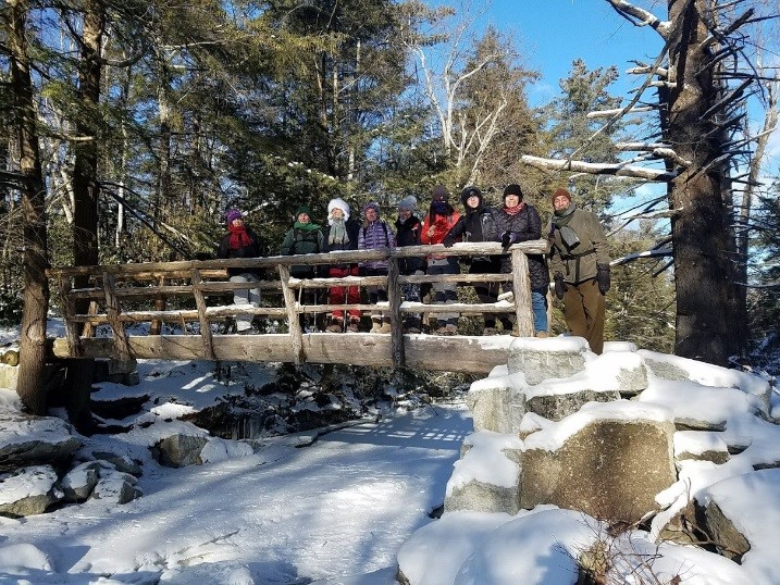
First Day Hikes 2019
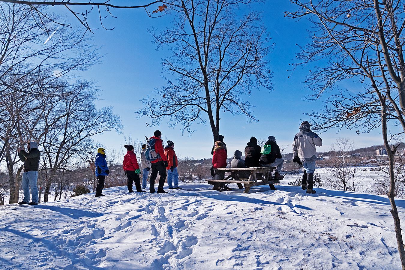
Whether it’s a much-needed elixir after a long holiday season or a first step in making (and keeping!) a resolution to be active in the new year, the 2019 First Day Hikes (FDH) are sure to draw thousands into New York’s great outdoors.
Each year on January 1, the New York State Office of Parks, Recreation and Historic Preservation (State Parks) and the Department of Environmental Conservation (DEC) host these family-friendly events on public parkland across the State. This year’s line-up of 79 hikes includes some exciting new destinations in communities on the shores of Lake Ontario, Lake Champlain, and many more!

The popular, outdoor New Year’s Day tradition is in its 8th year. The first First Day Hikes were held in Massachusetts in 1992, but have since spread nationwide. This year marked the first time the FDH went ‘international’, with events held in neighboring Ontario, Canada.
Here in New York, the event has grown significantly since its inception. The 2019 First Day Hikes will be offered at more than 51 state parks and historic sites with some facilities offering multiple hikes for different age groups, skill level and locations. In addition, DEC will host 19 hikes at wildlife areas, trails and environmental education centers. Staff from State Parks and DEC, along with volunteers, will lead the walks and hikes, which range from one to five miles depending on the location and weather conditions.

For last year’s event, Mother Nature really tested people’s mettle. With frigid temperatures and snowy conditions across the state last New Year’s Day, a number of parks, sites, wildlife areas and nature centers cancelled or postponed their First Day Hike program, but many soldiered on and welcomed participants all bundled up who were looking forward to heralding in 2018 in the outdoors.
In fact, a pair of intrepid First Day Hikers braved the elements and joined not one, but two (!) First Day Hikes out in western New York. A Miami couple honeymooning in Niagara Falls attended the morning First Day Hike at DeVeaux Woods State Park, and had so much fun they decided to join the afternoon ice-covered FDH program at iconic Niagara Falls State Park (shown below).

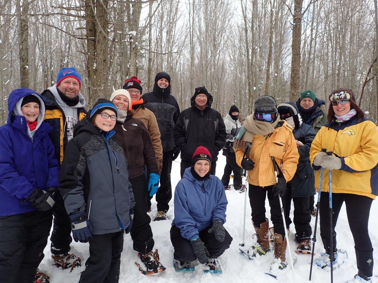
Some host locations welcome dogs on leashes and several have flat, even surfaces for strollers. Participants are encouraged to contact the park for information and pre-registration where noted. A sample of this year’s programs feature a seal walk, walking history tour, snowshoe waterfall hike, pet-friendly treks, bird count gorge walks, military musicology, canal towpath walk, and other fun options.
If conditions permit, some First Day Hikes may include snowshoeing or cross-country skiing with equipment for rent if available, or participants can bring their own. Many host sites will be offering refreshments and giveaways. A map and details about hike locations, difficulty and length, terrain, registration requirements and additional information are listed at parks.ny.gov and dec.ny.gov.

This New Year’s Day, be inspired by the Florida newlyweds who attended two hikes in a single day in Niagara, or the hundreds of brave souls who joined the gorge walk at Taughannock Falls State Park in the Finger Lakes (shown above), or the families and friends who embrace the winter wonderland at state parks and DEC sites across our state… and start your own tradition today.


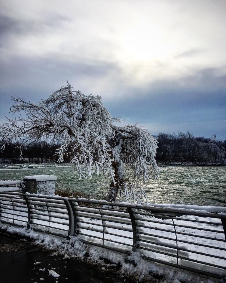
A Real Winter Wonderland
It is without question that Niagara Falls State Park is one of the most beautiful places our state and country has to offer, drawing an average of nine million tourists every year. People come from all over the world to experience the power and wonder that is Niagara Falls. Designated as a national historic site and the nation’s very first state park, it comes as no surprise the amount of attention it receives.
However, something most people miss out on is the endless beauty of Niagara Falls in the winter. Watching the cascading water crash through the pure white snow and ice creates a unique and memorable experience only attainable during the winter. Visiting the Falls in the wintertime offers tourists stunning views and the beauty of freezing mist covering the landscape.


The newly constructed Cave of the Winds pre-show attraction is now open year-round and offers audiences interactive and virtual exhibits as well as an escape from the chilly temperatures.
Although the Park has received some attention recently pertaining to the beautiful winter wonderland, some articles have mentioned the falls being “iced over” or “freezing over”. It is important to note that the only documented incident of the Falls being frozen completely came in March of 1848 when the Buffalo Express Newspaper stated the cause to be ice damming at the mouth of Lake Erie. The installation of an ice boom at the mouth of the Niagara River has made the likelihood of this event recurring very low if not impossible. Even during the infamous Polar Vortex of 2014 the Falls continued to flow.

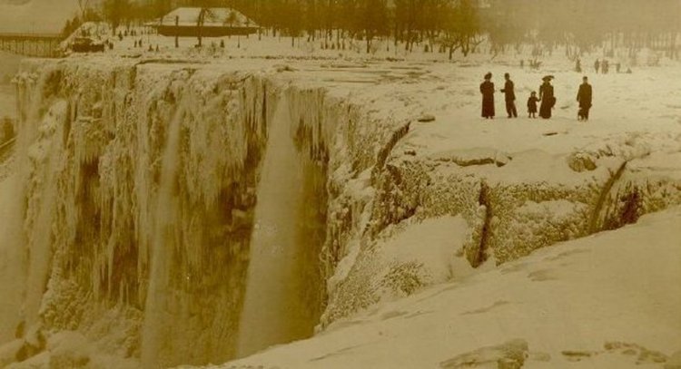
This does not mean that it has not come very close to freezing since then. During the early 1900’s tourists would often walk out onto “ice bridges” forming across the top of the Falls. This activity proved to be very dangerous and was forbidden after February 1914.

All photos provided by State Parks Naturalist Nicole Czarnecki were taken during the Winter Wonder Photography hike. Look for other events at Niagara Falls and surrounding parks this winter on their Facebook page.
Post by Kristin King, State Parks
