Rebuilding NYC After the Great Fire: Clay Mining on Staten Island

In 1836 Balthasar Kreischer emigrated from Bavaria to New York City with plans to help rebuild the city after the devastating fire the previous year.  The Great Fire of 1835 burned across 50 acres and destroyed 674 buildings.  Kreischer and his partner, Charles Mumpeton established the Kreischer Brick Manufactory, a firebrick businesses with locations in Manhattan, Staten Island, and New Jersey.  In the neighborhood now known as Charleston on Staten Island, he began mining for clay that would then be shipped to brickwork factories in Manhattan.  The business flourished until Kreischer’s death in 1886.  A few years after his death, the factory burned down, and although it was rebuilt, the business never recovered.

The remnants of the clay mining are still visible today from the hiking trails of the park.  Some of the clay pits have filled with water and provided habitat to new flora and fauna, while others remain dry and are home to flourishing skunk cabbage.  There are areas along the trails where you can still find signs of the former inhabitants of the area, untouched glimpses into the lives of those who once lived in this beautiful area.  Outside of the Interpretation Center are some of the historic Kreischer bricks in the walkway, guiding you away from the rush of city life and into the quiet serene that is Clay Pit Ponds State Park Preserve.

balthasar kreischer
Balthasar Kreischer. Image courtesy of the Staten Island Museum Collection.
kreischer bricks
Kreischer bricks at Clay Pit Ponds State Park Preserve.

Post by Clare Carney, OPRHP, Clay Pit Ponds State Park Preserve.


Finding the Footpaths: Creating Trail Maps for New York State Parks

Almost every state park facility in New York has a trail system. As such, it is important that each park have a trail map so visitors can find their way around. Several steps go into creating a trail map including: talking with the park manager, going into the field, and analyzing the data.

The best way to obtain data is by using a Geographic Positioning System (GPS) unit. Parks uses the Trimble GeoXT, which makes a digital map as it collects points, documenting the route travelled as well as any important features. This particular unit comes with a backpack-mounted antenna to increase satellite reception, which is important in heavily wooded areas.

trimbles
Trimble GPS units. The GeoXT, on the right, creates a map in real time. The GPS captures lines and points, takes pictures and is water resistant.

The first step is to talk with the park manager about what he or she wants. It may be that the park has no trail map, only a small portion needs to be updated, or the park is seeking approval on a proposed route. Before heading out, the surveyor uploads reference data to the GPS including park boundary, existing trails and any other useful data. Then, they go the park and start hiking.

maddy 1
Maddy Gold collecting data in Clarence Fahnestock State Park.

In the field, it is important to document every trail, even if it is not an official trail. This is important for rescue teams trying to locate an injured person within the park. Other notable features to collect include: scenic views, picnic areas, restrooms, parking lots, bridges, eroded areas, blaze color, and more.

When the surveyor is confident they have collected all relevant data, they take the data back to the computer and put it into a program called GPS Pathfinder. This program corrects for any inaccuracies in satellite reception by matching the points against current imagery.

mapping 1
GPS Pathfinder Office with data and Differential Correction Wizard. This software corrects for satellite discrepancies and produces the most accurate data possible.

The last step is to put the corrected data into GIS (Geographic Information Systems). This program allows the surveyor to produce a map using the features recorded on the GPS. With all the information about the park in hand, the surveyor sends a draft of the trail map to the park manager. When the park manager is satisfied, the map can be published for use by the public.

mapping 2
ArcGIS window showing the shape file for the state of New York.

Post by Maddy Gold, OPRHP SCA Intern.

One fish, two fish, small fish, big fish: The recent story of fish in Lake Minnewaska

Big fish eat smaller fish, smaller fish eat zooplankton, zooplankton eat phytoplankton, and phytoplankton produce their own food. If smaller fish eat all of the zooplankton, what’s to stop the phytoplankton from multiplying out of control? If the big fish eat all of the smaller fish, will the big fish still be able to sustain their population? Whenever an organism is added to or taken away from an ecosystem, it acts like a pebble thrown into a pond. There’s the initial splash, then there are ripples that radiate outward affecting everything in their path.

In 2008, a “pebble” was thrown into Lake Minnewaska. This pebble was a type of minnow called a Golden Shiner.  Exactly how the Golden Shiners entered the lake is not certain, however they are a common bait fish so it is  possible that they were introduced to Lake Minnewaska by someone who was hoping to hook the catch of the day! If that was the case, the odds would have been against that fisherman.  For several decades prior to the occurrence of the shiners, there were no fish reported in the lake. Lake Minnewaska has been very acidic in the past, making it an unhospitable environment for most fish to live in. Recently, the pH in the lake has begun to rise to a level closer to neutral, making the lake more inhabitable for fish.

snakes in water
Two Northern Water Snakes compete for a Golden Shiner in Lake Minnewaska. Photo taken by Nicholas Martin, Park Educator, Minnewaska State Park Preserve.

The introduction of a predator to the food web in Lake Minnewaska caused a trophic cascade. A trophic cascade is when a top predator is added to or removed from a food chain. The effects of the addition or loss of this predator are experienced all the way down the food chain. The shiners’ predation on the zooplankton drastically decreased their population. The ripple continued spreading outward because the loss of the zooplankton meant the loss of a major plant consumer. The phytoplankton could then grow and multiply without restraint. The result was an algal bloom in 2011 that turned the lake green and decreased the visibility to less than three feet. As a result, the Minnewaska Swimming Beach was closed for a month that summer.

Minnewaska State Park Preserve
A view of Lake Minnewaska with the Catskills in the background from on top of the quartz conglomerate cliffs surrounding the lake. Photo by John Rozell, OPRHP.

The algal bloom showed us that Lake Minnewaska’s ecosystem had been severely altered by the shiner introduction.   Another ‘pebble’ was tossed in 2012; the “big fish on the block” made its appearance. Largemouth bass entered the lake and filled a role at the top of the food chain.  Bass are avid predators, and they began preying on the shiners.  Electrofishing, the use of a weak electrical current in the water to temporarily stun fish, has been used in the lake every year since the shiners appeared in order to monitor the fish populations. In 2013 there was a large population of 10,000 – 15,000 golden shiners and 700 – 800 largemouth bass in Lake Minnewaska. In 2014 no shiners were observed during electrofishing and the number of bass had increased by 60%. Did the bass population increase because they had an ample food source in the shiners? What will happen to the bass population now that they have lost this food source? We can only wait and see.

signage
It is important not to transport plants or animals from one environment to another. Doing so can start a chain of events that can drastically alter the balance of the ecosystem. Sign by Nicholas Martin, Park Educator, Minnewaska State Park Preserve.

Post by Laura Davis, Park Educator, Student Conservation Association/AmeriCorps Intern, Minnewaska State Park Preserve.

Sources:

Dr. Richardson SRBP Lecture at Suny New Paltz February 2015.

“Baitfish Regulations.” General Regulations. DEC, http://www.dec.ny.gov/outdoor/31416.html. 24 June 2015.

Richardson, David C. “Why Is Minnewaska Lake Turning Green: Changes in Acidity and Fish in the Sky Lakes.” Shawangunk Watch 18 (Summer 2013): 1-3. Print.

Lauren Jorgensen, Kristen Husson, and Karen Terbush. Minnewaska State Park Preserve Lake Minnewaska Water Quality Report. Rep. Albany: NYOPRHP, 2012. Print.

On the Front Lines in the Battle Against Invasive Species: Strike Teams!

Invasive Species Strike Teams are an important part of environmental stewardship; they are the protectors and defenders of our native plants and wildlife! Invasive plants are fast spreading and can create ecological changes that crowd out native plants and alter habitats to make them unsuitable for native insects or animals. The goal of the strike teams is to manually remove these plants in areas of significance to protect our native biological diversity. A diverse landscape is healthier and more robust, better able to fend off threats and adapt smoothly to changes, such as climate change.

1

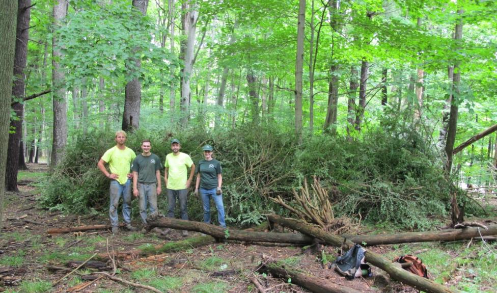
Above: Our 2014 Western Strike Team in Letchworth State Park, showing off all their hard work removing Japanese Barberry (Berberis thunbergii). Japanese barberry is a commonly planted ornamental which escapes into forest understories and increases incidence of Lyme disease.

What is a Strike Team anyway?

The New York State Parks Invasive Species Strike Teams consist of seasonal employees who travel throughout New York State to remove invasive plants from the most valuable areas of our Parks. These teams of four camp near their project areas to accomplish the goals of the Invasive Species Program. All these removals are done with manual hand tools, such as pick mattocks, shovels, machetes and loppers. Our strike teams are always up for the physical challenge and have made incredible headway against some large opponents.

2

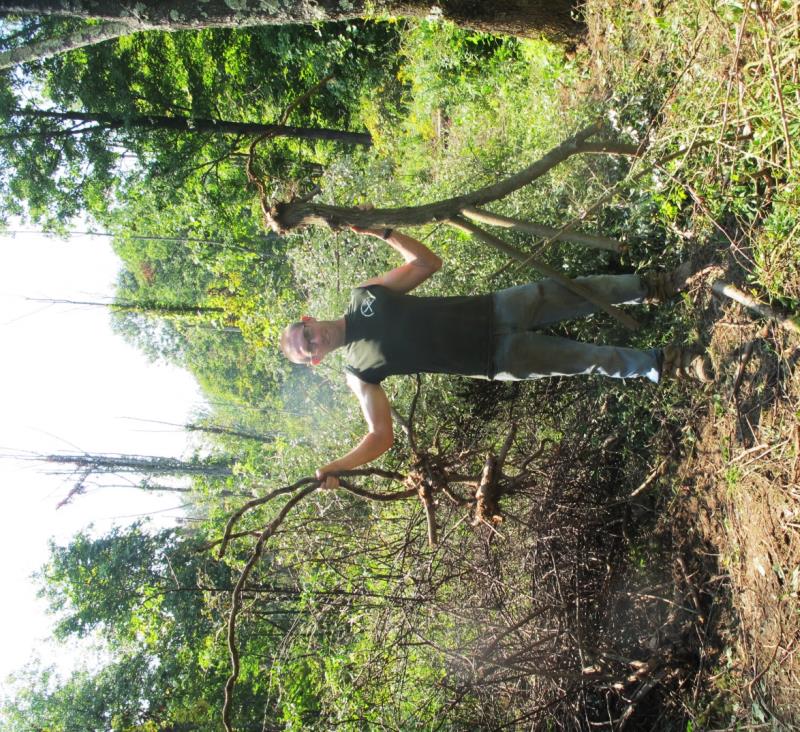
Above: A strike team member from 2012 who proudly showcases the large autumn olive (Elaeagnus umbellata) he removed with hand tools, determination and brute strength. Machinery is used to remove large shrubs, but our strike team got there first in this case!

What are the goals?

Invasive Species Program staff has had many successes in controlling invasive species  by carefully selecting projects geared toward terrestrial invasives, which can be controlled manually and through adaptive management.

3

Above: The 2015 Eastern Strike Team wishing everyone well from Grafton Lakes State Park, outside of Albany. You can see some of our most often used tools in this photo (From L-R: the ax mattock, pick mattock and loppers), as you can see, other essential elements in their toolbox include the hard hat and gloves!

Accomplishments

Starting in 2008, six interns and volunteers assisted with invasive species removals state wide. Since 2010, State Parks has employed 46 seasonal staff to remove invasive species. In the past 5 years over 1100 new observation points were entered into the program iMap Invasives, a national database reflecting new sightings of invasives. On average, strike teams remove 19 different species per year at their project sites. Some of the native species which are protected by the invasive species program include: twinleaf, American Hart’s tongue fern, sky blue aster, cardinal flower, Chittenango ovate amber snail, the Karner blue butterfly, several warbler species, mountain mint, bushy cinquefoil, and slender blazing star.

Above: Two examples of native plants which benefit from strike team controls. On the left, the spring flowering twin leaf (Jeffersonia diphylla). On the right, the stunning late summer red of the cardinal flower (Lobelia cardinalis), a plant loved by pollinators.

One of the best ways to reduce invasive species is avoid introducing them in the first place. Please check what is planted ornamentally in your yard and remove plants or shrubs which are invasive and replace them with natives. Learn more information about New York’s invasive species on the NYS DECs Prohibited and Regulated Invasive Species List

For more information regarding Invasive Species Awareness Week (July 12-18) events, check out the New York Invasive Species Information Blog.

Post by Alyssa Reid, Minnewaska State Park Preserve (OPRHP). Photos courtesy of OPRHP.


Explore NYS Parks’ Waterways

Now that the ice is finally gone and the water is warming up, those of us who love paddling are heading out to our favorite spots. Where better than to check out the ponds, lakes, and waterways than in New York State Parks? Whether just for exercise or to enjoy the sun and sky while paddling across the water, getting out in your kayak or canoe is a chance to relax and see a little of the world that can only be experienced from the water.

Grafotn PRK_2664
Kayakers at Grafton Lakes State Park. Photo courtesy of OPRHP.
Dog in Kayak with life vest_Lilly Schelling
Life vests are also available for pets! Photo by Lilly Schelling, OPRHP.

The Marine Services Bureau of State Parks has just conducted training for Park staff who will be offering American Canoe Association kayaking lessons and tours in parks this summer.  Check out for their kayak program schedules.

Marine Services Bureau is also hosting two paddling events.  W.O.W. (Wear it On the Water) Paddle Fest will be held in two locationson Saturday, July 11 at Gilbert Lake State Park and Saturday, August 15 at Fair Haven Beach State Park.  This free event will feature free kayaking lessons, a Life Jacket Flash Mob, and Sport Fishing Clinics along with other family fun and friendly activities to help you enjoy the water.

Whether exploring for turtles, watching for osprey, fishing, or listening for the slap of a beaver’s tail, we want to remind you to be mindful of the safety of yourself and others who are paddling with you.  Take a free online paddle safety course at www.paddlecourse.com.  Don’t pack it, but wear your life jacket, be boat sober, and leave a float plan letting someone know where you are paddling and when you will return.

Marine Services Bureau encourages all paddlers to obtain an IF FOUND Sticker to identify your boat.  Write your name, cell phone and alternative phone number on the sticker and affix to your boat.  It’s a great way to return a lost boat or help law enforcement rescue a capsized kayaker.  Get your IF FOUND sticker by sending a legal sized self-addressed stamped envelope to NYS Parks, Marine Services Bureau, IF FOUND Sticker, Albany, NY 12238.

If Found
Photo by Ro Woodard, OPRHP.

So grab your life jacket and paddle and head out to the nearest lake or pond to enjoy the serenity and natural surprises that are just a paddle away.

Picture1


Post by Ro Woodard, Marine Services Bureau (OPRHP).