

The 2025 Ryder Cup is coming to New York State Parks, and it’s going to be a historic moment for both golf and New York. For the first time, Bethpage State Park is hosting the highly anticipated men’s golf competition between the United States and Europe. The PGA of America will bring the prestigious tournament to the famed Black Course this September. Like the Super Bowl, the FIFA World Cup, and the Olympics, the Ryder Cup is the peak event of professional golf and fans around the world couldn’t be more thrilled.
Continue reading Ryder Cup 101: What’s All the Excitement About?Category Archives: NYSParks in the News

Countdown to the Ryder Cup at Bethpage State Park
Just over a year ago, at the conclusion of the 2023 Ryder Cup at Marco Simone Golf and Country Club outside Rome, Italy, there was a Silver Putter Presentation to the host of the next Ryder Cup. That silver putter plaque now hangs inside the clubhouse at Bethpage State Park where the 45th Ryder Cup matches will be contested in late September 2025.

You have a few months left to view that silver putter up close before 24 of the world’s best players bring their own prized putters – and the rest of their golf bags – to Bethpage Black for the 2025 Ryder Cup. The countdown is officially on for a competition at what is considered one of the best, and hardest, courses in the world.
Continue reading Countdown to the Ryder Cup at Bethpage State Park
Explore New York State Parks On The Go
Now, information and tips on your New York State Parks and Historic Sites are as close as your mobile device.
Help plan your visits this summer using the free, new New York State parks Explorer App, developed by staff at State Parks and the Office of Information Technology Services.
Information is tabbed by favorites by both visitors and staff, golf courses, state historic sites with a military heritage, some lesser-know parks that some treasurer as “hidden gems, and parks that feature historic lighthouses.
The app can help guide visitors to top destinations and new must-see locations with rotating curated content. It offers quick access to park information, including directions, hours, amenities, fees and rates, trail maps, helpful know-before-you-go details, and the ability to receive important updates and alerts.
Visitors can also link directly to online camping reservations and easily access select State Parks’ social media channels to share their experiences.
The appl can be dowloaded by visiting for Android devices by visiting Google Play Store, NY State Parks Explorer App and for iOS devices by visiting Apple Store, NY State Parks Explorer App.
“This season more than ever, people are looking to spend time in the outdoors whether taking nature breaks, day trips or overnight getaways,” said State Parks Commissioner Erik Kulleseid, “and this new Parks Explorer App is a helpful tool for families on the go to plan the perfect adventure with ease. To stay in the know and make the most of your park visit, I encourage New Yorkers to download the app today.”
New York State Executive Director of Tourism Ross D. Levi said, “With an unparalleled collection of parks, historic sites and recreation trails across the state, exploring New York’s State Parks system is a perfect complement to any Empire State vacation. The new State Parks Explorer App will offer information and suggestions that help keep New York a top travel destination for residents and visitors alike.”
Interim New York State Chief Information Officer Jeremy Goldberg, “The Office of Information Technology Services is proud to partner with the Office of Parks, Recreation and Historic Preservation to share technology that makes it easier for residents to visit parks across New York State. The Parks Explorer App allows residents to plan new outdoor adventures prior to visiting parks and demonstrates how NYS is harnessing the power of technology to bring New Yorkers closer to nature.”

State Parks Take Star Turn For Oscars Week
The Oscars were years away when a young Syracuse native came to icy gorges and waterfalls outside Ithaca in the Finger Lakes as a silent movie star in 1917.
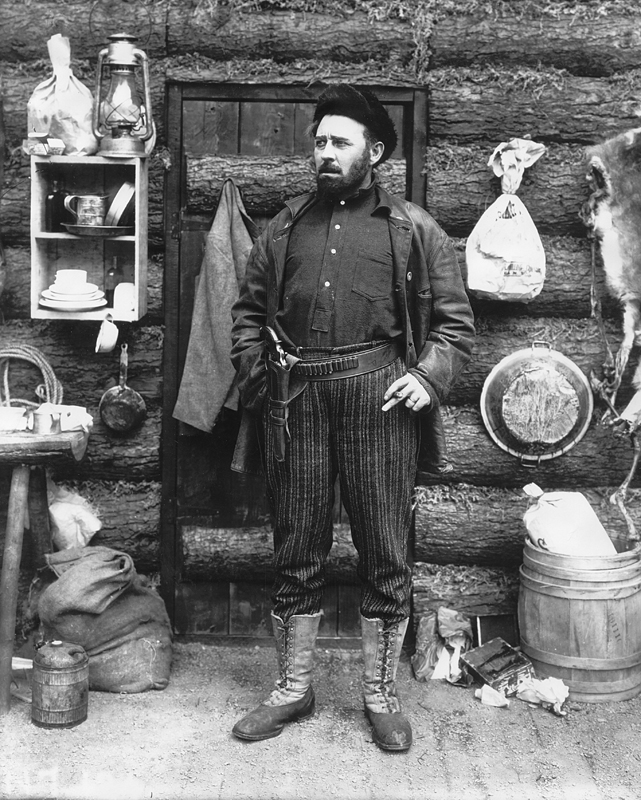
In a film entitled “The Great White Trail,” 20-year-old actress Doris Kenyon played the role of married woman falsely accused of infidelity fleeing to the wilds of Alaska to start a new life.
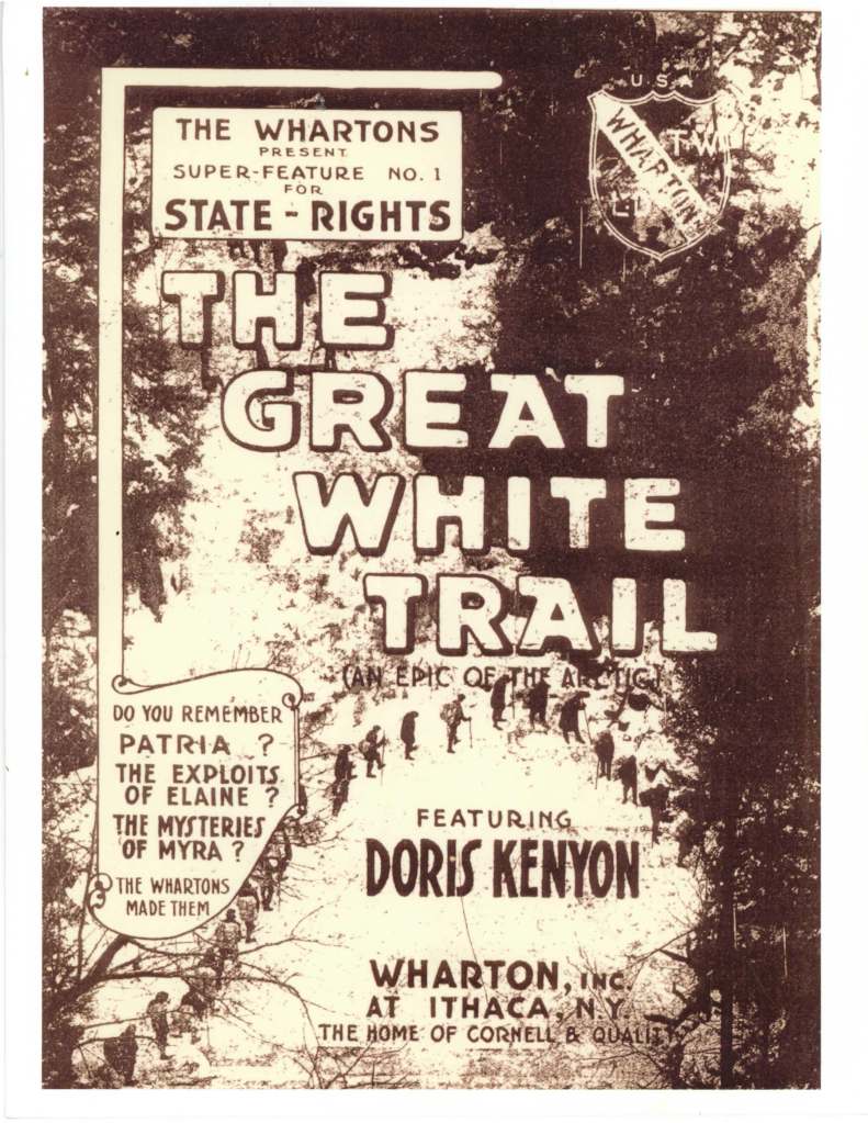
Ithaca-based producers (and brothers) Leopold and Theodore Wharton thought that the area’s rugged winter beauty, highlighted by the frozen 115-foot Lucifer Falls, could stand in for Alaska. A few years later in 1920, this dramatic setting in Tompkins County became the 1,256-acre Robert H. Treman State Park. The first Oscars awards for the burgeoning motion picture industry, now firmly anchored in Los Angeles, finally arrived in 1929.
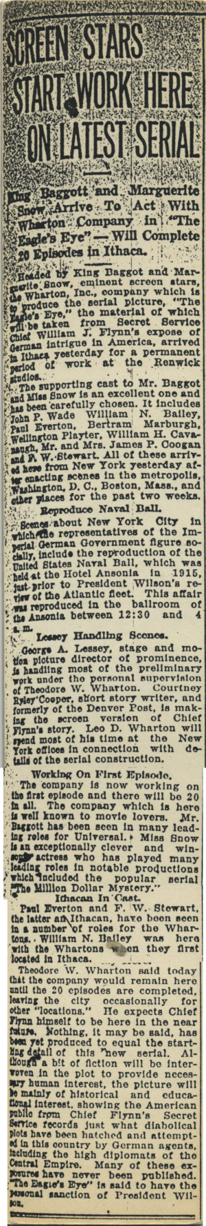
Ithaca played a critical role in the history of the silent movie industry when the Wharton brothers ran their studio in what is now the city’s Stewart Park from 1914 to 1919, making more than two dozen movies. There were stunts and antics, including when the brothers bought a trolley car from the city to film careening off a bridge, and the time when dozens of skunks from a local farm were rented for a scene, only to escape, spray the actors and crew, and shut down production.
Shooting in their studios and on location in the dramatic gorges around the area, the Whartons brought famous movie stars of that era to Ithaca, making it the unofficial capital of the silent film industry, as reflected in these early newspaper clippings from the Wharton Studio Museum.


“The Wharton brothers and Ithaca were pioneers in this emerging art form. Some very unique history happened here,” said Diana Riesman, executive director and co-founder of the museum.
One of the Whartons’ silent film stars, Irene Castle, lived in Ithaca after marrying local resident Robert E. Treman, the son of Robert H. Treman, a prominent upstate political and financial leader who later donated the land used for The Great White Trail that became the state park now bearing his name.
Many of the Wharton’s film reels were destroyed in 1929 when the highly-flammable nitrate film caught fire in their lawyer’s garage in Ithaca. However, the original Wharton studio building still exists in the park, and is used by the city public works department for maintenance.
In the years since the freewheeling Wharton brothers, the variety of landscapes found in State Parks have shared the spotlight many times in a wide range of films, television programs and other productions, from the well-known and prestigious to the obscure and unsung.
Some are little nuggets of film history. Did you know, for example, that iconic comedian Henny Youngman’s final film appearance came in 1995 at the former state Kings Park Psychiatric Center in what is now part of Nissequogue River State Park in Suffolk County?
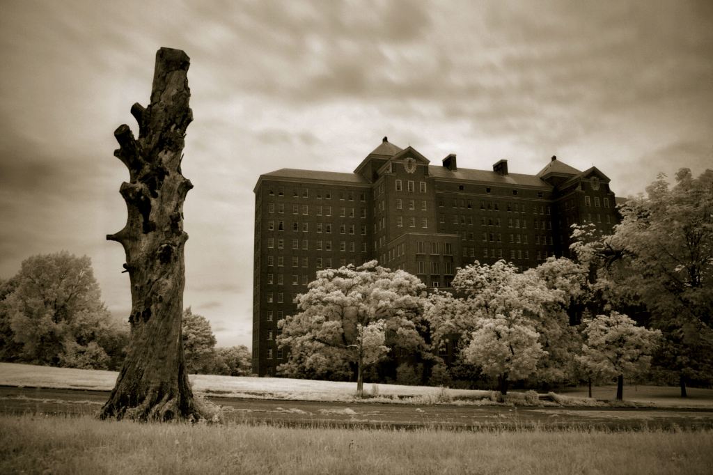
In the little-remembered “Eyes Beyond Seeing,” which was the story of a mental patient with religious delusions, the then 89-year-old “King of the One-Liners” played a brief cameo role as another patient who thinks he is … Henny Youngman. He must have cracked himself up. <rimshot>
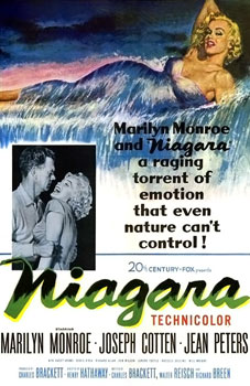
Niagara Falls State Park has one of the most dramatic backdrops available anywhere, within numerous films using the thundering cataracts, including the 1953 film “Niagara.” This film noir thriller helped establish the sensuous image of 27-year-old actress Marilyn Monroe, who received top billing for the first time in her budding career.
In recent years, other films at the falls have included the comedy “Tammy” in 2014 with Melissa McCarthy, part of which was filmed at the always-torrential “Hurricane Deck” at the Cave of the Winds. The park also was featured in “Henry’s Crime” in 2010 with Keanu Reeves, whose falsely-accused-of-a-crime Buffalo toll taker has a romantic interlude at the falls.

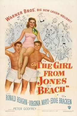
Surf and sun always make for a good movie, with Jones Beach State Park and other shoreline parks in Long Island long popular as shooting sites. In 1949, middle-aged actor and future President Ronald Reagan filmed a romantic comedy at Jones Beach, aptly titled “The Girl From Jones Beach.”
Other films of more recent vintage that have shot at this iconic oceanside park have included “Men in Black 3 (2012), “Teenage Mutant Ninja Turtles 2” (2016), and “Mildred Pierce” (2011).
The 2004 romantic film “Eternal Sunshine of the Spotless Mind,” filmed in part at Camp Hero State Park on Long Island at Montauk Point, had one of the characters uttering the phrase “Meet me at Montauk,” which can still be found on t-shirts and promotional items for the area.


If skyline is what a filmmaker needs, the Big Apple has that in spades. Numerous films have been shot at State Parks in the city, including “The Secret Life of Walter Mitty” (2012 at Bayswater Point State Park), the senior citizen heist comedy “Going in Style” (2017 at East River State Park), and “Still Alice,” a 2014 film in which Julianne Moore plays a woman coping with an Alzheimer’s Disease diagnosis that was shot in Denny Farrell Riverbank State Park.
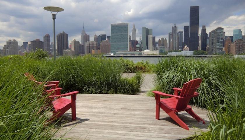
The 2015 short film “The Bench,” is set at a bench in Gantry Plaza State Park, with its spectacular views of the midtown Manhattan, where a suicidal man has a conversation with a passerby that changes his life.

This dramatic cityscape park has been used in many feature, foreign and student films, including the 2016 Ricky Gervais comedy “Special Correspondents,” the 2019 comedy “Holiday Rush” about a DJ dealing with losing his job, and “Here Today,” a 2019 May-September comedy with Billy Crystal.
Some thirty miles north of the city, the former estate of philanthropist John D. Rockefeller – now the Rockefeller State Park Preserve – has been used for many films and television shows, most recently the 2019 gangster epic “The Irishman” by director Martin Scorsese, who shot from the 13 Bridges Trail to film driving scenes on Route 117 below.
The office at the preserve stood in for the police station in the 2001 prankster cop comedy “Super Troopers.” A scene where a police car goes screeching into reverse down a highway was filmed on Route 117 in the park.

Further up the Hudson Valley, the great lawn for the estate at the Staatsburgh State Historic Site along the banks of the river was used as a backdrop for the 2019 superhero movie “Avengers Endgame.”

In the Capital Region, Ang Lee’s “Taking Woodstock” (2009), a story of how the Woodstock music festival of 1969 came about, was filmed at Cherry Plain State Park in the rugged eastern hills of Rensselaer County. And parts of the 1998 film “The Horse Whisperer” were shot in Saratoga Spa State Park.
Out in western New York, the base-jumping scene in “Get Him to The Greek” (2010) was filmed in the spectacular gorge setting of Letchworth State Park, often called the “Grand Canyon of The East.”

And sometimes, an even more primeval look is what’s called for. That’s what producers of the low-budget 1983 caveman comedy film “Luggage of the Gods!” found in the rocky trails and mountains at Harriman State Park. Filming centered around the Claudius Smith Den, a rock shelter dating back to Native American times and used during the Revolutionary War by a notorious gang of Tories.
Finally, something altogether darker might be needed, and State Parks has places for that, too. The grounds of Glimmerglass State Park and the nearby 50-room, 18th century estate at Hyde Hall State Historic Site were the setting for a short horror film “A Nightmare Awakes.” The film tells a story of Mary Shelley, the young author of the book Frankenstein, as she begins to experience vivid hallucinations.
So, State Parks can offer aspiring filmmakers a setting for every story. Such films are part of the state’s efforts to attract such activity through the Governor’s Office of Motion Picture & Television Development, which has drawn productions that have contributed billions of dollars to the state’s economy.
And should you ever wish to see The Great White Trail, the silent film set at Robert H. Treman State Park, or another classic silent film, check the event page for the Wharton Studio Museum or Taughhannock Falls State Park . The film has been shown during summers at the park in recent years and is still drawing an audience. A silent movie screening is planned there for summer 2020.

Brian Nearing, Deputy Public Information Officer for NYS Parks.
Learn more about the silent film era in Ithaca in the Finger Lakes at the Wharton Studio Museum.
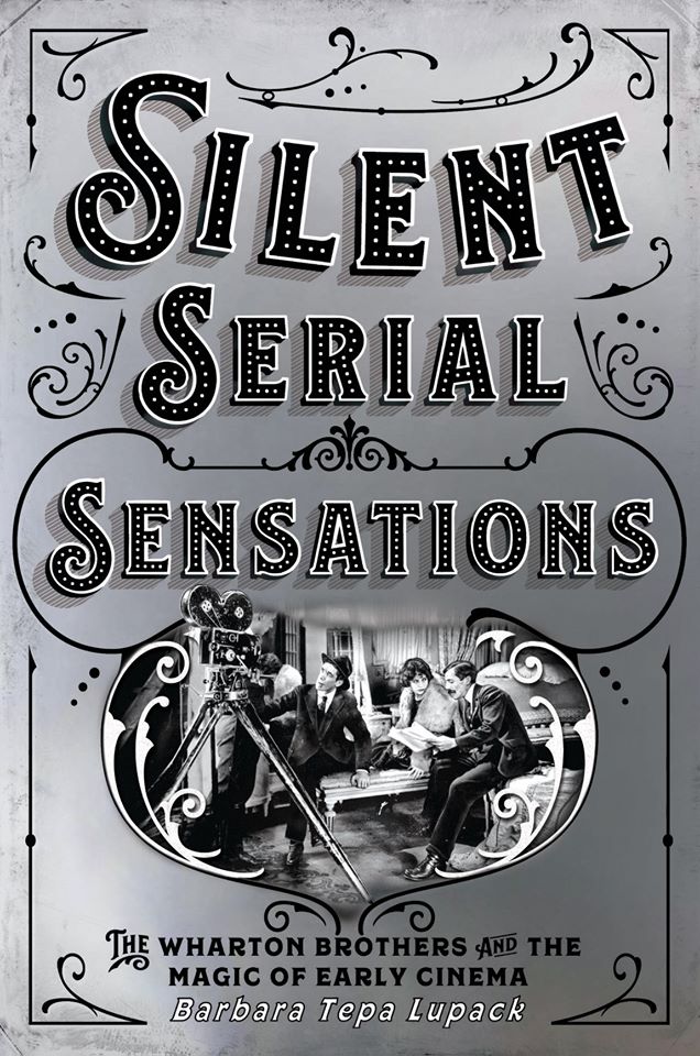
Cornell University Press is releasing a book in April on the history of Wharton films in Ithaca entitled Silent Serial Sensations by Barbara Tepa Lupack.
The Wharton Studio Museum is part of the newly-created Finger Lakes Film Trail, which also includes the George Eastman Museum in Rochester, and the Case Research Laboratory in Auburn. The sites host film events, lectures, and screenings.


Fire On The Mountain
As all park managers know, times of peace and quiet in the park are only temporary.
On a Friday afternoon last month, Hudson Highlands State Park in the Taconic Region felt the transition from tranquil to full-throttle, when after a trail steward with the New York-New Jersey Trail Conference, crossing the Newburgh-Beacon Bridge over the Hudson River, noticed smoke to the south. And it was coming from Sugarloaf Mountain in the park.

It was a little after 4 p.m. on September 20 when the steward reported his sighting to State Parks. Almost simultaneously, Hudson Highlands Park Manager Evan Thompson — elsewhere in the 8,000-acre park — was told by a patron of a potential fire on nearby Breakneck Ridge. That report turned out later to be of the Sugarloaf blaze, but added to initial uncertainty over possibly having two fires at the same time.
Gathering staff to investigate Sugarloaf and knowing that recent dry conditions had increased the danger from wildfires, Thompson also called the New York State Park Police, Parks Forest Rangers, and the Department of Environmental of Environmental Conservation for assistance. He learned that DEC officers were responding to a search at Minnewaska State Park Preserve and another fire at Cranberry Mountain, both several counties distant.
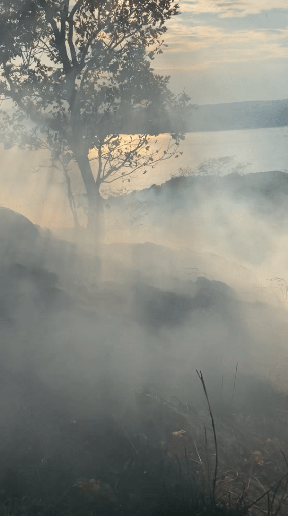
After additional contact with the Park Police, DEC sent Ranger Robbi Mecus to the park. Park Police officer Jeremy Pickering arrived at the trailhead as did Mecus, with the pair leading a crew of eight on a 2.4-mile hike up 900-foot Sugarloaf Mountain. There, they found a fire covering about nine acres at the rocky summit.
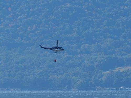
A state Police helicopter was called in, dropping water drawn from the nearby Hudson four times before dark in an effort to slow the spread of the fire. The crew stayed on the mountain digging fire lines — areas where dried grass, brush, trees and other flammable materials were cut and shoveled away to create a buffer line difficult for fire to cross. The ground crew only stopped when it became too dark to see safely.

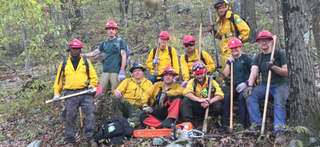
By then — perhaps only four hours after the first report of the fire — Taconic’s Assistant Regional Director Tom Watt had asked for additional assistance from DEC and the State Parks’ adjoining Palisades Region. State Parks Forest Ranger Lt. Mickey Cahill from Palisades Region arrived, sharing Incident Commander responsibilities with DEC Forest Ranger Captain Greg Tyrrell.
Watt also started calling State Parks facility managers at home to gather manpower needed for the next day; he soon had a roster of twenty Parks staffers scheduled to report to an 8 a.m. briefing Saturday. Meanwhile, several other agencies and organizations offered help, including the Albany Pine Bush Preserve.
A crew of more than 30 was ready to climb the mountain by that morning, coming from State Park’s Palisades Region as well as from the far reaches of the Taconic Region on the other side of the Hudson. Splitting into two teams, the crews continued the physically-demanding process of hand-digging fire lines — also called fire breaks — around the perimeter of the rugged, rocky mountain top.

At Sugarloaf, crews made these breaks by scraping the ground clean of combustible material for up to four feet, with a foot-wide, 6-inch deep cut into ‘mineral earth’ along the center of the break. Hazard trees nearby were downed, both to protect crews and prevent fire-weakened trees from falling across the fire containment line to act as a bridge for fire to spread. Digging these breaks was challenging due to the steep, rocky terrain and a thick layer of duff, which is decomposed organic material overlaying the soil.
From the air, a State Police helicopter continued dropping water gathered from the nearby Hudson River. And the fire itself was not the only hazard for those working the mountain. Crews had to watch out for fire-loosened rocks that tumbled down cliff faces without warning, as well as for rattlesnakes and ground-dwelling wasps. By Saturday evening, a preliminary line of fire breaks had been created to isolate the blaze, which by this point was estimated to cover about 14 acres.
By Sunday’s 8 a.m. briefing, the fire-fighting crew had swelled to more than 75 people, with many working to strengthen fire lines in temperatures that soared to more than 90 degrees. In some instances, their work meant abandoning a section of line that would be difficult to defend — on a very steep slope, for instance, where burning material could tumble downhill across the line to spread — and dropping back to dig a new section.
Crews also created ‘cupped’ lines by piling material on the downhill side of lines meant stop burning material from sliding over and spreading. By this time, the fire covered about 25 acres.
On Sunday morning, a complex network of fire hoses was laid out just outside the fire line. The hoses were routed to portable tanks at locations where tanker trucks could deliver water; gasoline-powered pumps provided water pressure to the hoses. Air operations by helicopter continued throughout the day. By nightfall on Sunday, the fire lines were as good as could be expected given the difficult terrain, but hardly impregnable.

Monday dawned sunny and warm, with crewing working to improve the fire breaks. More than a mile of containment line was dug or improved on the rugged western flank of the fire, and by the end of the day, Park Rangers were confident that the lines were good. That evening, Rangers and Parks staff lit backfires on the east side of Sugarloaf to consume combustible material under controlled conditions. During the night, numerous large trees fell from roots being burned and weakened by the fire, with crews cutting trees that crossed the line.
The next day, Parks Rangers and DEC backburned privately-owned land to protect a cluster of houses at the north end of the mountain. With permission of the landowners, crews successively lit fires inside the containment lines and allowed the fires to consume burnable material. Crews then went to work to extinguish flames within 25 feet of the lines. That evening, crews again patrolled overnight to ensure that the fire remained ‘on the black side of the line.’

By Wednesday morning, Sept. 23rd, the most immediate danger had passed, although the fire was still burning inside the break lines, which by this point contained about 50 acres. Secure breaks and less combustible material inside the lines meant that the hardest work was done.
The fire was contained, with no one hurt and no homes damaged. The Wilkinson Trail to Sugarloaf summit has since reopened, although part of the trail at the summit is rerouted to avoid steep, eroded and dangerous conditions.
A smaller team remained at the mountain for several days to conduct “mop-up” operations, like corralling equipment that had been distributed over miles of trails and patrolling for sparks or breaches of the fire line.
Given the nature of the soil and the terrain, the fire was expected to continue to smolder and burn until rains finally put it out. The cause of the fire remains under investigation, although initial reports suggested it might have been an illegal campfire. State Parks rules allow fires only in designated areas under supervision by an adult.
Post by Steve Oakes, manager of Old Croton Aqueduct State Historic Park and Philipse Manor Hall State Historic Site
How will the plants and animals that make up the Sugarloaf Mountain ecosystem respond and recover from this fire? Keep your eye on the NYS Parks Blog for a future post on that subject.

