NOAA’s Marine Debris Blog has a blog post up on the great work that New York State Parks is doing in Long Island parks to clean up Sandy debris. The featured image is post-storm damage at Jones Beach State Park, by NYS Parks.
Category Archives: Park Projects

Protecting Mud Lake

NYS Parks often has to perform a balancing act between meeting the needs of the wildlife and environments, and providing the opportunities for recreation that sometimes negatively impact ecosystems, but also allow people to experience nature and buoy the public interest in maintaining and protecting our parks.
Mud Lake, at Robert V. Riddell (RVR) State Park in Delaware County, is a good example of such a place. The NY Natural Heritage program (NYNHP) completed a vegetation map based on field surveys at Robert V. Riddell State Park, and has documented one rare insect species and a high quality dwarf shrub bog, both at Mud Lake. Mud Lake is a very scenic feature in the park, but as park use increases, this fragile ecosystem faces greater risks. For this reason, the Office of Parks, Recreation and Historic Preservation (OPRHP) is looking to provide better visitor access to Mud Lake while protecting the fragile bog and pond habitat.
Given that RVR has only recently been designated a state park, there has been relatively little development beyond trail surveys and invasive species removal. Because the park is so close to Hartwick College, one of the most important uses of the park is for education and research, which only adds to the importance of protecting a rare and high-quality ecosystem like Mud Lake. Hartwick College has been a long time partner of State Parks and continues to utilize Robert V. Riddell State Park for educational opportunities.
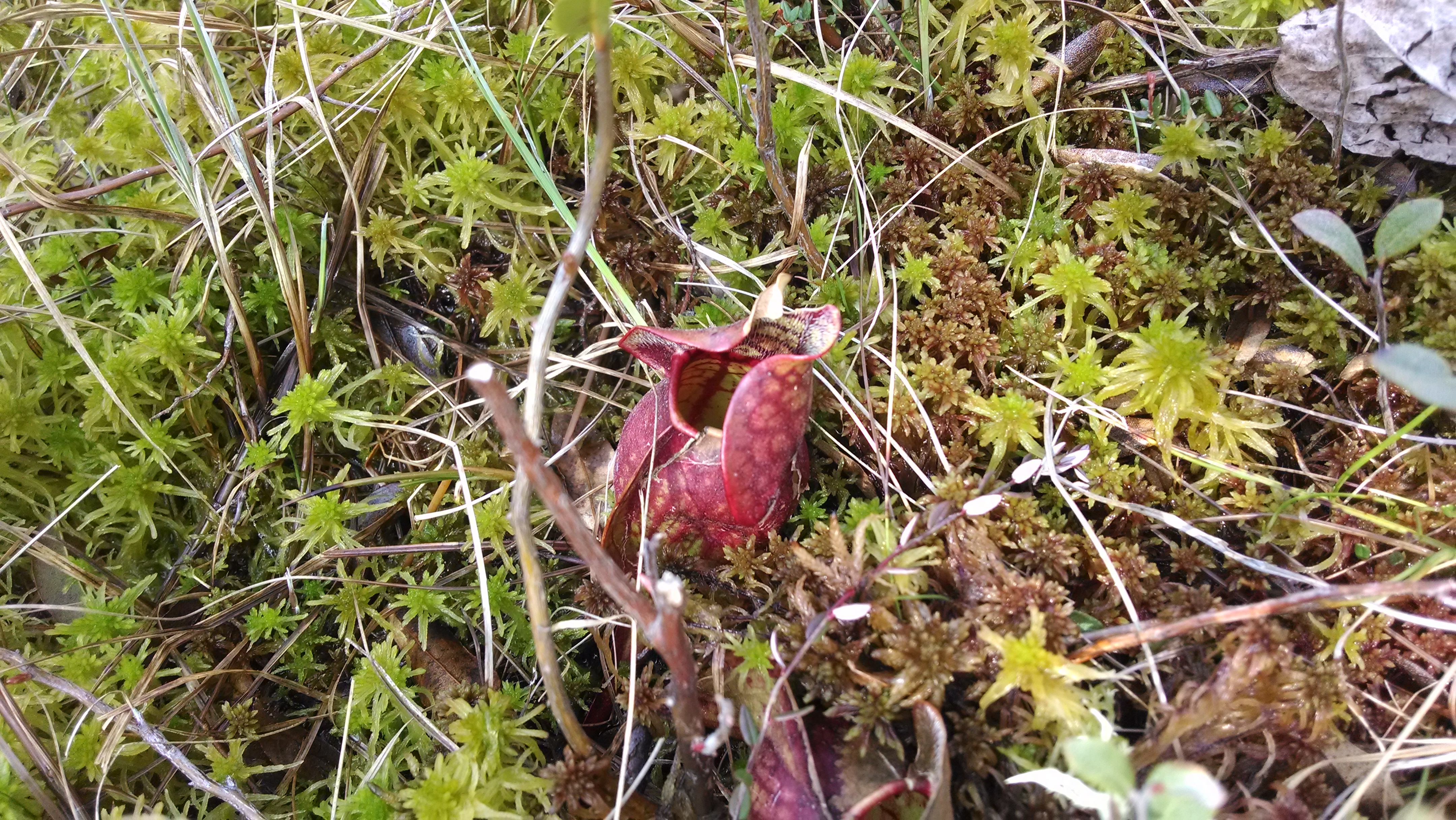
Mud Lake is located on the parcel of land recently acquired from Hartwick College. It’s a small, spring-fed pond surrounded by forest and circled by a narrow band of spruce and tamarack trees, transitioning to low shrubs, and finally to a floating mat of sphagnum peat at the edge of the open water. This type of ecosystem is called a dwarf shrub bog, and it is a particularly fragile environment. Wild cranberries only grow in dwarf shrub bogs, as do carnivorous pitcher plants and sundews. These plants can be found growing out of the peat moss.
The peat is strong enough to walk on, but the water flowing through the thick vegetative mat gives you the feeling of standing on a waterbed – I was afraid of falling through!

Visitor access to Mud Lake is challenging. Currently, there is no defined pathway that can take you from the edge of the forest out to the open pond and bog area. This means any park visitors that want to get a closer look are making their own paths through the edge of the bog, and putting fragile plants at risk of being crushed.
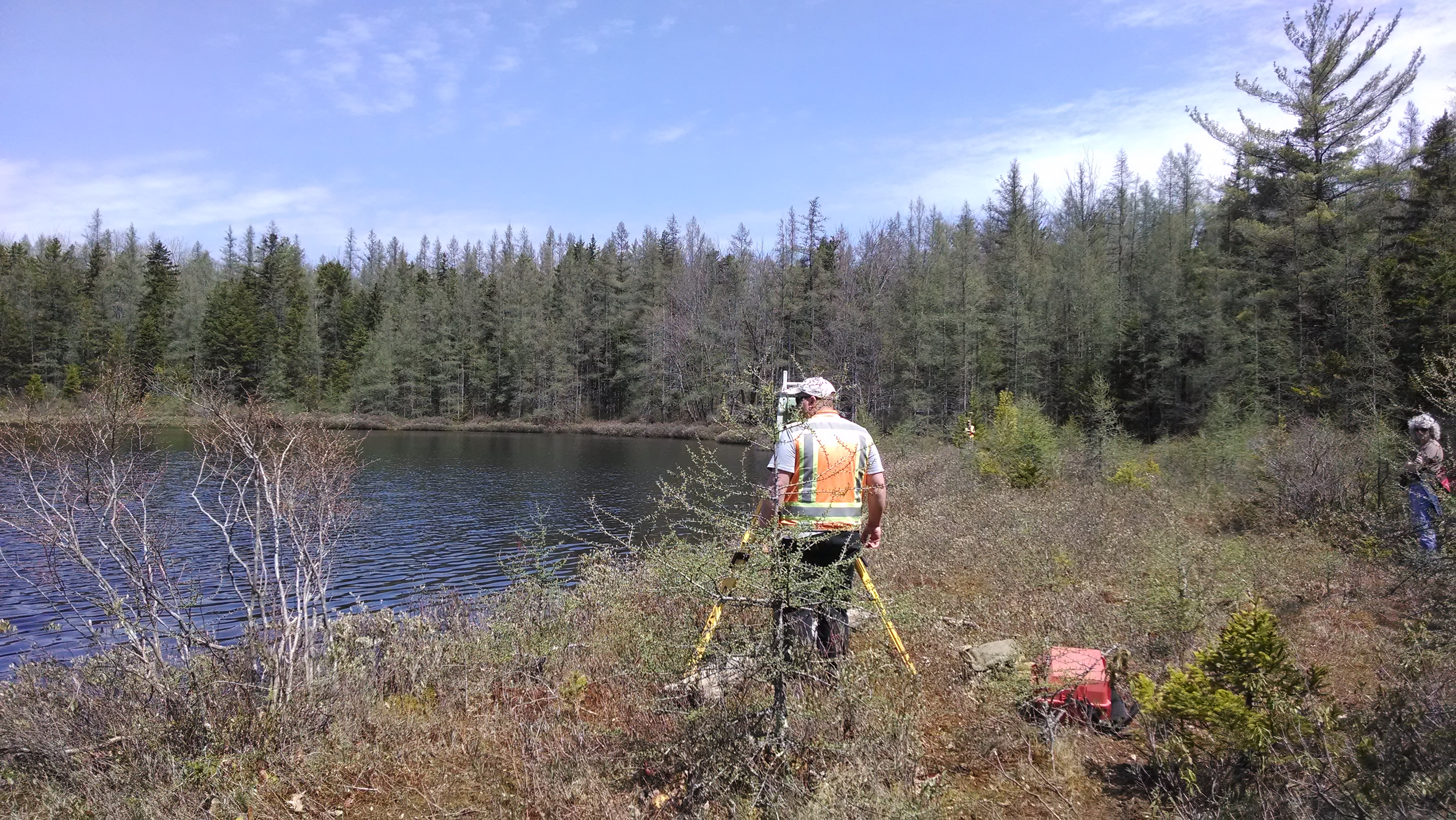
To protect Mud Lake and also to enhance visitor experiences, OPRHP is in the process of designing a boardwalk from the upland edge of the bog to the water’s edge, including a gathering space where groups of students and other visitors can be brought to view the bog. However, building a solid structure on a bog presents unique challenges. Last winter, core samples taken from the peat went as far as 27 feet deep and still did not hit hard earth. At the tree line, solid ground was 20 feet below the surface of the soft, damp peat layer. OPRHP is still working on resolving all the construction challenges in this project, but we are hard at work to protect Mud Lake.
featured image is of Mud Lake in early May. Post and photos by Paris Harper

Grassland Conservation at Green Lakes State Park
The NYS Bird Conservation Area Program (BCA) deems certain areas as especially worth protecting due to their importance as a habitat for one or more species. In general, a site is nominated because of its importance to large numbers of waterfowl, pelagic seabirds, shorebirds, wading birds, migratory birds, or because of high species diversity, importance to species at risk, or its importance as a bird research site. The Green Lakes BCA is located within Green Lakes State Park. Green Lakes is about 5 miles East of Syracuse and is bordered on the north by portions of the Old Erie Canal State Historic Park. The park offers an eighteen hole golf course, camping, biking, hiking, swimming, and cross-country skiing.

The Green lakes BCA is an important habitat for migratory bird species and it is a diverse species concentration site, meaning that many different kinds of birds use this habitat to nest, feed, and shelter. In particular, this BCA is unique because it contains significant tracts of both mature forest and grassland habitat, providing habitat for an unusually diverse suite of bird species. Grassland habitat, and the birds that depend on that habitat, have been declining throughout the northeastern U.S. The grasslands within Green lakes BCA represent the largest concentration of grassland habitat in the New York State Park system. This makes it a perfect shelter for grassland-breeding species including Northern Harrier (threatened), Bobolink, and Grasshopper Sparrow (special concern). In addition, the BCA contains a relatively large tract of interior forest, including old-growth forest, which provides important breeding habitat for mature forest birds, such as Ovenbird, eastern wood-pewee and wood thrush. Finally, the meromictic lakes, from which the BCA takes its name, provide stopover and foraging sites for many birds dependent upon open water, including Bald Eagle, Osprey, and Wood Duck.
The Green Lakes BCA is also in need of conservation. In the western portion of the Green Lakes State Park, the BCA’s important grassland habitat is currently undergoing succession, with shrubs and trees gradually becoming established within these fields. The majority of these woody plants are non-native invasive species. Continued establishment of woody plants will eliminate habitat for grassland-dependent bird species, many of which are state-listed. For this reason, NYS Parks has developed a grassland management plan to protect and conserve this important bird habitat.
The management plan calls for:
- Removal of woody vegetation from critical fields, and maintaining these fields as grassland bird habitat through regular mowing (every two to three years).
- Selective removal of hedgerows, which fragment the grasslands and provide travel corridors for nest predators such as raccoons
- Removal of invasive species, such as Pale Swallow-wort. These non-native species have the potential to significantly transform the current habitat within the BCA, and reduce habitat quality for a wide range of birds.
- Reducing the deer population. The deer population within the BCA is currently impacting the survival and regeneration of native vegetation, particularly within forested habitats.
For more information:
New York State Breeding Bird Atlas 2000, Maps and Species Lists
OPRHP 2010, Green Lakes State Park Master Plan
NYS Parks Bird Conservation Areas
The featured photo is the Green Lakes Bird Conservation Area at Green Lakes State Park. Photo by Lilly Schelling. Post by Paris Harper.

Benthic Barriers in Rudd Pond
No one likes to hop into the water on a hot day and find a slimy, tangled forest of plants. In many state parks, aquatic invasives plants encroach on public swimming areas, ruining recreational areas as well as habitat for native species in the same lakes and ponds. At Rudd Pond in Taconic State Park in Columbia County, a simple management strategy may prove to be an effective way to protect a swim area against unpleasant and unwelcome weeds.
Rudd Pond, at the southern end of Taconic State Park, is a popular swimming and fishing area, supporting populations of panfish, largemouth bass, and chain pickerel. Unfortunately, the pond also supports thriving populations of aquatic invasive species including water chestnut, curly pondweed, and Eurasian watermilfoil.
Benthic barriers are porous mats that are placed on the bottom of a lake or pond. They restrict sunlight from reaching the lake bottom in the areas where they are installed. The absence of sunlight restricts the growth of aquatic plants.
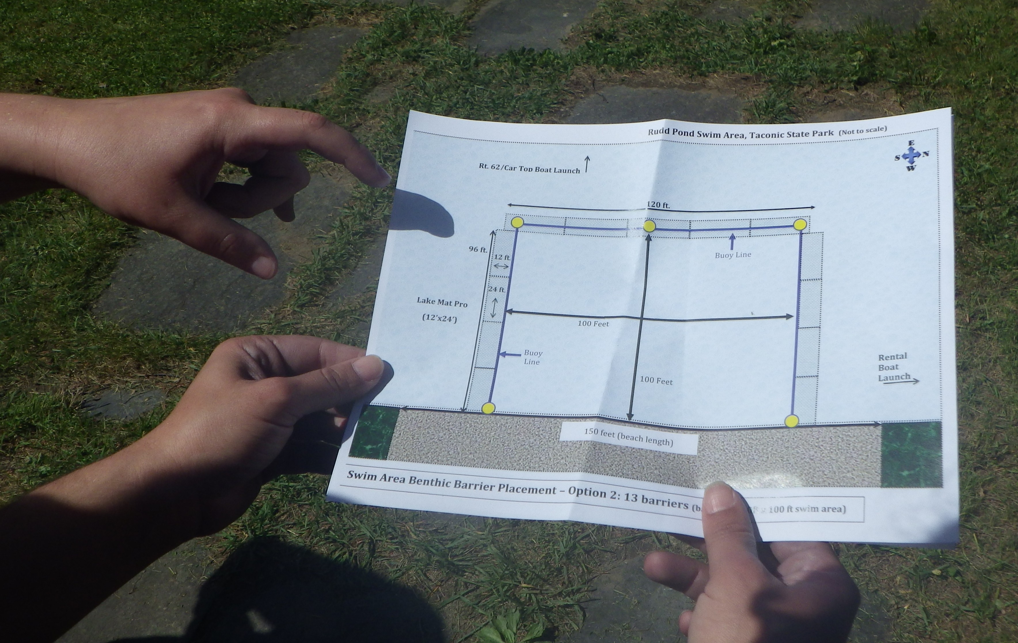
The benthic mats are used to create a buffer zone to prevent aquatic invasive species from threatening the utility of the public swimming area. An aquatic weed harvester is used to cut the plants below the surface in the main part of the pond. However, harvesters do leave behind fragments of plants that can regrow. There is no single perfect solution to managing aquatic invasives, but the use of several management strategies continues to show improvement at Rudd Pond.

Check out the NYS Parks poster on preventing the spread of aquatic invasive species
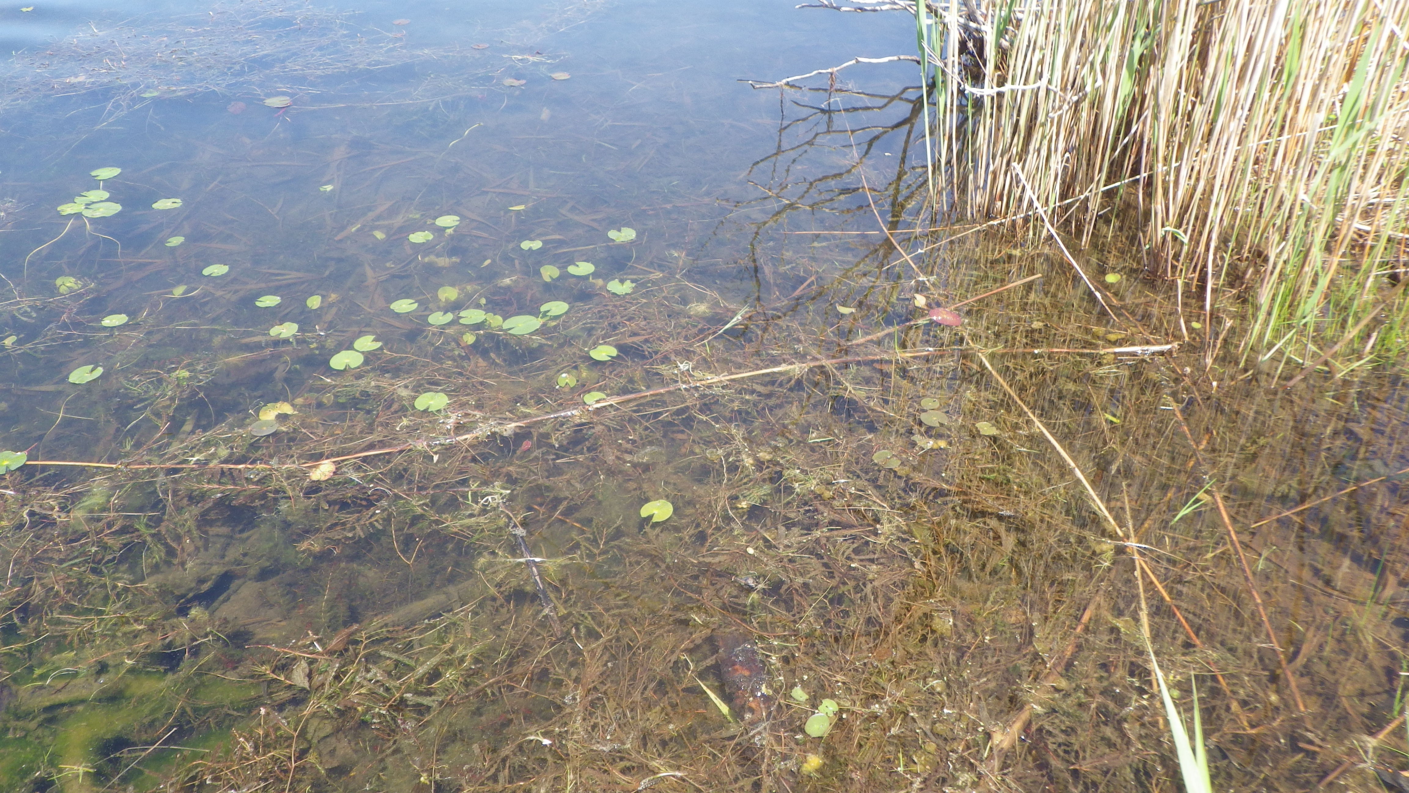
Featured image is of curly-leafed pondwater underwater adjacent to the Rudd Pond swimming area. Photos and post by Paris Harper.
Green Parking At FDR State Park
A project at Franklin Delano Roosevelt State Park aims to redesign the 6.2 acre parking lot in order to greater serve the goals of environmental sustainability and stewardship. The project will rehabilitate the lot’s surface, improve the efficiency of the parking layout and improve drainage and storm water runoff quality. The new parking lot will feature native trees and vegetation to visually soften the hard surface of the parking lot. Ultimately, the redesign will create a more welcoming and pleasant entrance experience to patrons visiting the popular pool and provide important benefits to the park’s wetland and lake by reducing the amount of nutrients (e.g. phosphorus) and typical parking lot pollutants that are currently flowing into these resources untreated.
This is a joint project between NYS OPRHP and the NY Department of Transportation (DOT). DOT has been tasked with reducing phosphorus loading from storm water runoff from public highways and other impervious surfaces within the Croton watershed. They identified the large pool parking lot at FDR as a project that would help them meet their phosphorus reduction goals. As this lot is in need of rehabilitation, DOT’s assistance with its upgrade will result in a net benefit for both agencies. DOT will provide design and construction management funding and assistance. OPRHP will fund the construction contract.
The Environmental Impact of Parking Lots
Parking lots can be bad for the environment for many reasons. More pavement means less green space, thereby reducing the number of trees and plants that serve as natural “air cleaners” by absorbing carbon dioxide in the air and releasing oxygen. It also means less open soil that can collect rainwater, which helps to replenish natural aquifers. Impervious surfaces, like asphalt, don’t allow rain to percolate into the ground; instead they channel rainwater to a storm drain. Stormwater runoff can be highly polluted with oil, grease, coolant, and other fluids which leak out of cars and collect on pavement until rain washes it into our lakes and streams, negatively impacting our health as well as the habitat and living conditions of fish and other aquatic life.
Another negative effect of parking lots is that they raise local temperatures through a process known as the “heat island” effect. Asphalt and concrete absorb and retain heat from the sun’s rays more than the surrounding ground. This in turn raises surrounding temperatures a few degrees.
The Project at FDR State Park
FDR State Park is located along the Taconic State Parkway, approximately 40 miles north of New York City. The park offers day use recreational facilities including picnicking, trails, fishing and boating and areas for field games. One of the central features of the park is a large outdoor pool that can accommodate up to 3,500 bathers at a time. The park is popular with local residents for walking, hosts many events throughout the year and is also used for winter activities.
To accommodate all these visitors, FDR State Park also has a very large parking area. The lot is 6.2 acres in size and primarily services the pool complex during the summer. It is also used year-round for access to nearby trails, picnic areas, and events. Storm water drainage from the existing lot is directed to storm drains that flow to a nearby wetland and then into Mohansic Lake, a large lake within the park.
The primary elements of the proposed design include:
- Parking Lot – The existing asphalt surface will be removed and replaced. The removed asphalt will be milled and reused or recycled. In addition, approximately 15,000 square feet of asphalt will be removed from an adjacent service road entrance and replaced with grass.
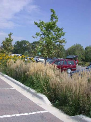
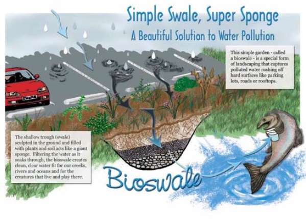
- Storm water treatment – The proposed plan includes the construction of new bioswales throughout the lot which will consist of a combination of soil, cobbles and native vegetation. Storm water drainage will flow into these areas before entering into the existing storm water drainage system. These bioswales will allow for biological filtration and treatment, breaking down many of the nutrients and pollutants found in typical storm water runoff. Native trees, shrubs, and ornamental grass species will be planted to reduce the lot’s heat island effect, improve aesthetics, and provide shade and wind breaks. Below is a photo of a typical bioswale that is similar to what will be installed.