Do You Know Sojourner Truth?

There are historic figures whose names we sometimes hear but whose story may have grown hazy. Sojourner Truth too often falls into that category.

Her famous “Ain’t I A Woman” speech of 1851 may still be familiar to a few, but unfortunately, the popular version has her speaking in the voice of the Deep South where she doesn’t belong. In fact, she’s a native New Yorker from the Hudson Valley.

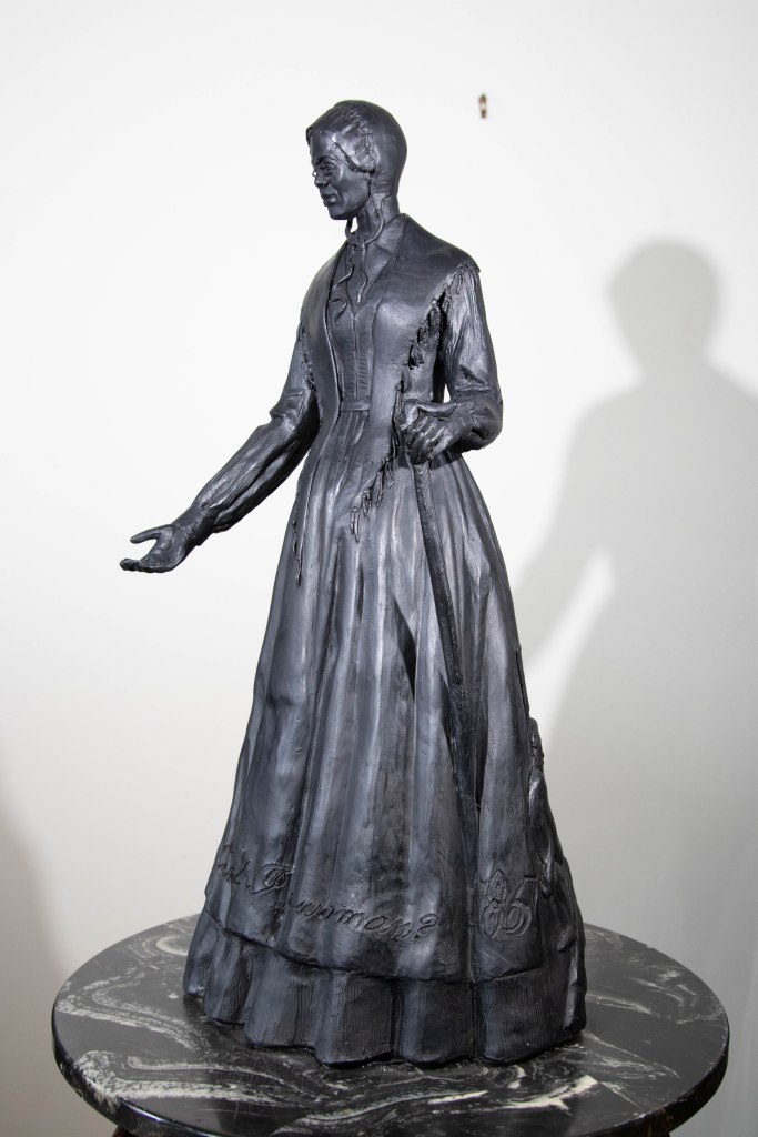
 A bronze statue of this famous 19th century African-American abolitionist and women’s rights advocate is being installed this month at the western entrance to the Walkway Over the Hudson State Park in Ulster County, so this is a good opportunity to get to know Sojourner Truth better.

The statue of Sojourner Truth that is being unveiled at Walkway Across the Hudson State Park.

She was born enslaved in 1797 to James Baumfree (alternatively spelled Bomefree) and Elizabeth ‘Mau-Mau Bet’, enslaved parents who were owned by a Dutch family in Esopus, Ulster County. Isabella, as she was named then, grew up speaking Dutch.

Some of the worst treatment she received as an enslaved teen came at the hands of her second owner because she didn’t speak or understand English, and he didn’t speak or understand Dutch. She bore the scars on her lacerated back, the punishment she received as a result of this language barrier, for the rest of her life. Later, she displayed these marks during her talks as a sign of the common mistreatment the enslaved received. Even after becoming fluent in English, contemporaries noted that she spoke with a Dutch accent, not a Southern one as a later popular account of her famous 1851 speech portrays.

I have as much muscle as any man, and can do as much work as any man.

I have plowed and reaped and husked and chopped and mowed, and can any man do more than that?

I have heard much about the sexes being equal; I can carry as much as any man, and can eat as much too, if I can get it.

Portion of Sojourner Truth’s “Ain’t I A Woman?” speech to the Woman’s Rights Convention in Akron, Ohio, as reporter on June 21, 1851, by The Anti-Slavery Bugle, of Salem, Ohio. A version published more than a decade later had her speaking in Southern voice.

Despite her low birth status, Sojourner Truth became one of the leading voices for human rights and universal suffrage in the 19th century. Her life as an itinerant preacher working on behalf of the enslaved, newly freed, and women, especially Black women, left a legacy that has kept her in the public consciousness.

Her birth, two years before New York’s Gradual Emancipation Act took effect on July 4, 1799, would have her remain enslaved well into adulthood. Her owner John Dumont struck a deal with Isabella and agreed to free her in 1826. After receiving a life-threatening injury while working in his fields, she required time to heal. Dumont used the healing time as justification to renege on his promise of freedom. In retaliation, she leaned upon her trust in God, and “…walked away by daylight” to find liberty, taking her youngest daughter Sophia with her.

This map shows where Sojourner Truth began her walk to freedom in Esopus, Ulster County, (pin on the right) westward to Marbletown (pin on the left).


This bold journey by the 29-year-old was the first of several she would make in her life. After walking many miles, she reached a settlement at Marbletown headed by Quakers, who were known anti-slavery abolitionists. A man there directed her to a farm owned by Isaac Van Wagenen, who held no enslaved people and had joined Quakers and Methodists working for the emancipation of all the enslaved. Van Wagenen paid $25 to Dumont for Isabella and her daughter, then freed her, allowing her to work off the cost as a domestic for the household.

While working for the Van Wagenen’s, Isabella faced her second tribulation. The Gradual Manumission laws in New York restricted the sale of enslaved children out of the state, lest they not be freed at the appointed time. Her young son Peter, through a series of twists and turns, was illegally sold and taken to far-off Alabama, from which he might never return. Upon hearing the news, Isabella ran to the wife of her former owner, who had orchestrated the sale, but was firmly rebuked. Isabella reached out to others, all of whom made light of her frantic state over her missing child. Realizing how others perceived her plight, she called upon God and proclaimed calmly that she would have her son back.

Walking the road, she happened upon a man who directed her to some Quakers, assuring her they would help. Not only did they provide lodging for her that night, they provided money to press her complaint in court. In 1828, Isabelle won her son’s return _ marking one of the first legal cases where an African-American woman prevailed in court against a white person.

The judge in the case declared that the “boy be delivered into the hands of the mother—having no other master, no other controller, no other conductor, but his mother.” It was to Isabella’s horror that when alone with her son, she discovered he now bore scars from being physically abused during his distant enslavement.

From Ulster County, Isabelle moved to New York City, where she worked as a domestic for people involved in the anti-slavery movement. It is during this time that she began her training in public speaking. Illiterate throughout her life, during her time in New York City, she increased her knowledge of the Bible, listening intently during Bible study. She believed strongly in the idea of everyone having a direct relationship with God and leaned heavily upon hers. Like many abolitionists she became known for her radical and anti-cleric religious views. More of a spiritualist than a traditional churchgoer, Truth often spoke of being abused by ‘Christians,’ many of whom strongly supported slavery and participated in mob violence against blacks and white members of anti-slavery groups.

During her time in New York City, she worked, saved money and opened a bank account, reunited with a brother and sister who had been sold as children, won a court case for slander, and grew as a preacher, speaking out on the street and at anti-slavery gatherings.

But by 1841, divisions within New York’s abolitionist community, the rise of the pro-slavery Democratic party and her son Peter’s death at sea while working as a sailor, pushed her onward. Heeding inner divine guidance, she changed her name from Isabella Baumfree to Sojourner Truth in 1843 and headed east out of New York City. She traveled the road to Brooklyn, then out to the Long Island, into Connecticut and ultimately reached Massachusetts, speaking ‘truth’ to hundreds along the way about the inhuman practice of enslavement and human rights. Her speeches were well received and comments about her talks appeared repeatedly in newspapers across the region.

Her strong desire to be treated as an equal manifested itself not just in her teachings on tolerance, but her desire to live what she preached. The early 19th century saw waves of religious and social reform movements sweeping through the northern part of the U.S. Many within the anti-slavery movement believed strongly in equality, prompting Abolitionist and other religious reformers to establish utopian communities that foreshadowed the communes of the 1960s. One of the early examples was the Northampton Association in Northampton, Massachusetts, which Sojourner Truth joined in 1844.

The Narrative of Sojourner Truth, the story of her life, was dictated to her friend Olive Gilbert during their time together at Northampton. According to Professor Margaret Washington, a noted scholar on Sojourner Truth, and author of Sojourner Truth’s America, “…embedded in Northampton was a commitment to revolutionize civilization.” Frederick Douglass once commented that “The Northampton air was full of “isms…Grahamism, mesmerism, Fourierism, transcendentalism, Communism and Abolitionism. But it was to be commended because of its deep commitment to emancipation.”

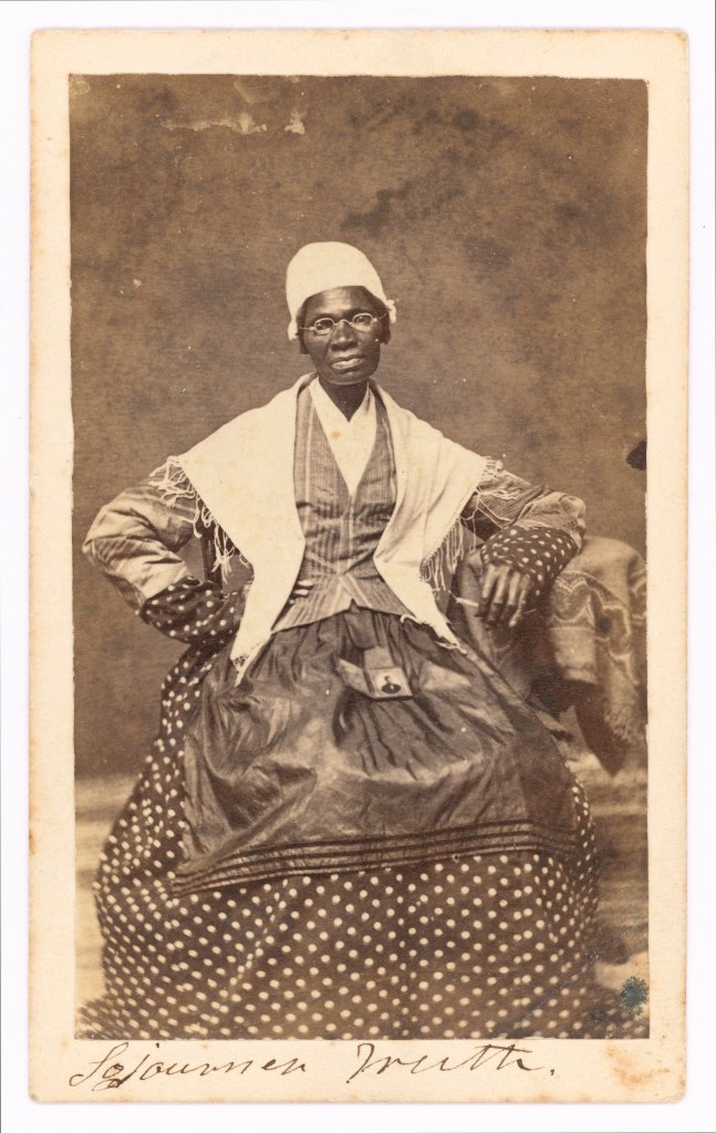
The Northhampton community was home to many involved in the anti-slavery movement. A mix of farmers, artisans, clerks, teachers, ministers, intellectuals, and other professionals, it reflected the equality that Sojourner longed to see in America. While in residence Sojourner worked in the laundry, but otherwise spent her time traveling the region preaching and teaching on civil rights, abolition and suffrage. It was her plan that the Narrative, along with photographs of herself, which she had inscribed with the famous words, “I sell the shadow to support the substance,” would provide an income to support her vision that many women didn’t have.

“I sell the shadow to support the substance.” — Sojourner Truth. Carte de Visite, circa 1864, in the collections of the Library of Congress (http://www.loc.gov/pictures/item/97513239/)


The stirrings of the coming Civil War took her from Massachusetts to Washington, D.C., where during the war she recruited men for the Union Army, and later worked for the Freedmen’s Bureau, helping to feed thousands of newly freed enslaved. Her awareness of their plight, and the endless need for work and sustenance moved her to the realization that without land of their own the freedmen would not prosper. This began her work on petitioning for space within the territory of Kansas.  With the end of the war she returned to the road, again focusing on universal suffrage and women’s rights.

But support for all the disenfranchised in the country wasn’t there. It became increasingly clear that a choice had to be made between voting rights for Black men or women, but both would not succeed at once. The ‘race or gender’ struggle created a schism within the suffrage movement that was being led by Elizabeth Stanton and Susan B. Anthony, who wanted to see white women gain suffrage first. Their public comments and involvement with strong pro-slavery Democrats pushed many long active suffrage supporters like Sojourner Truth and Fredrick Douglass to distance themselves.

Following the passage of the 15th Amendment which gave voting rights to Black men (but not women regardless of race) in 1870, Sojourner moved to Battle Creek, Michigan, and returned to the women’s movement. Leaving behind the animosity of the past, she and Douglass again joined forces with Stanton and Anthony to push for voting rights for women until failing health caused her to retire from public life. On November 26, 1883, the 86-year-old Sojourner Truth died at her home in Michigan. The national adoption of women’s suffrage was still four decades away.

Her popularity as a long standing, dynamic public speaker on human rights and suffrage, someone often quoted or referenced in newspapers and other periodicals of the time, brought hundreds to her funeral. Sojourner Truth’s life reflected her deep and abiding belief that justice for all would someday come.  The shadow of her legacy is deep and abiding, and reflects a journey toward equality that she knew would continue.

As she wrote, “I don’t expect I will to live to see it, but when this generation has passed away, there will be a grand change.”   


Cover picture of Sojourner Truth: Credit Wikipedia Commons; Wood, Norman B., “White Side of a Black Subject,” (1897)

Post by Lavada Nahon, Interpreter of African American History, state Bureau of Historic Sites

Sojourner Truth Resources

Web based

The Sojourner Truth Project

Offers critical analysis of Truth’s famous Ain’t I a Woman speech, dispelling the inaccurate use of southern dialect in the later transcription and focusing on the earlier transcription of the speech which was more true to her northern Afro-Dutch roots.

Sojourner Truth – Identifying Her Family and Owners

Information about Sojourner Truth’s family and the slave holders associated with them from the New York Slavery Records Index.

This Far by Faith – Sojourner Truth

This PBS series highlights the spiritual lives of historic figures and provides details about Sojourner Truth’s religious beliefs, spiritual life and ministry.

Narrative of Sojourner Truth; a bondswoman of olden time, emancipated by the New York Legislature in the early part of the present century; with a history of her labors and correspondence drawn from her “Book of life.”

This work includes several important texts about Sojourner Truth’s life, including a dictated autobiography and some correspondence. Full text transcript available via PDF.

Selected Books

Grigsby, Darcy G., Enduring Truths: Sojourner’s Shadows and Substance (2015).

Mabee, Carleton and Mabee, Susan Newhouse, Sojourner Truth: Slave, Prophet, Legend (1993).

Mandziuk, Roseann M. and Pullon Fitch, Suzanne Sojourner Truth as Orator: Wit, Story, and Song (1997).

Gilbert, Olive, The Narrative of Sojourner Truth (1850)

Painter, Nell Irvin Sojourner Truth: A Life (1997).

Schmidt, Gary D. (illustrated by Daniel Minter), So Tall Within: Sojourner Truth’s Long Walk Toward Freedom (2018) [children’s book].

Stetson, Erlene and David, Linda, Glorying in Tribulation: The Lifework of Sojourner Truth (1989).

Washington, Margaret, Sojourner Truth’s America (2011)

Get out And Explore … The Saratoga/Capital Region of New York State Parks

Centered on the confluence of the Hudson and Mohawk Rivers, between the Adirondacks and the Catskills, the Saratoga/Capital Region of New York State Parks offers opportunities for both hikers and paddlers.

Covering Albany, Schenectady, Rensselaer, Saratoga Washington, Schoharie, Montgomery and Fulton counties, the region includes a dozen state parks, as well as eight historic sites that reflect a history dating back to the Colonial era.

Maps for hiking trails and a variety of other useful information on State Parks, including those in the Saratoga/Capital Region, are now available on the NYS Parks Explorer app.  The free app, which is available for use on Android and iOS devices, is easy to download, user friendly and allows patrons to have park information readily available.

As with all hikes, there are a few things to remember beyond carrying a mobile phone. Check the weather forecast before you go, and dress appropriately. Wear sturdy, yet comfortable shoes or boots, bring water and snacks, and perhaps carry a camera to capture what you see. Be aware of your surroundings and mindful of hikes on steep terrain or those that go near cliff tops. Having a small first-aid kit available in case of an emergency is never a bad idea.

Hiking poles are also useful and can transfer some of the stress of hiking from your knees and legs to your arms and back.

Trail maps are also available on each individual park website page at parks.ny.gov and at the main office of each park. Be sure to download maps ahead of time or carry a paper copy as a back up

In addition to the name and distance of each designated trail in a park, the maps include facilities such as parking, comfort stations, park offices, nature centers, campsites, and boat launches. To learn more about NYS Parks trails CLICK HERE.  

Hikers should plan their route in advance, know how long a trail is and how long it ought to take to finish. Since daylight is not an unlimited resource, tossing a flashlight or headlamp into your backpack is a good form of insurance, should you unexpectedly find yourself on the trail as dusk approaches.

Parks facilities are carry-in, carry-out, so don’t leave trash behind. Follow Leave No Trace principles to keep trails clean for everyone.

Additionally, as incidents of tick-borne diseases surge in the state, it is always important to check yourself for ticks after being outside, even if it is only time spent in your own backyard.

Lastly, as the COVID-19 pandemic continues, remember to practice safe social distancing, particularly in parking lots and at trailheads, and use face coverings when a distance of six feet cannot be maintained.  To learn more about important COVID safety guidelines, CLICK HERE.

Albany County


John Boyd Thacher State Park, 830 Thacher Park Road, Voorheesville, NY 12186 (518) 872-1237: This popular park protects more than 2,000 acres and includes more than 20 miles of trails. In the heart of the park’s South Zone, the iconic Indian Ladder Trail is both scenic and historic, originating as a Native American footpath and offering sweeping views of the Hudson-Mohawk Valley. The trail descends the Helderberg Escarpment, a 100-foot tall limestone cliff rich with fossils.  There is a staircase at both ends of the trail and a walk between the two along the Clifftop Trail will make a loop hike of about 1.25 miles. Trail heads are at the LaGrange parking lot and the Visitor Center. Due to the COVID-19 pandemic and social distancing protocols, this trail is one-way only, and must be started at the LaGrange lot. After climbing down the stairs, the trail runs along the base of the cliff,  passing under seasonal waterfalls and over an underground stream. Interpretive signs along the way tell of the geologic and cultural history of the area. This is a rocky trail with steep drop-offs. Wear sturdy shoes and please stay on the trail. 

Indian Ladder Trail at Thacher State Park

In the park’s lesser-traveled North Zone, which has no picnic area or restrooms, try the Fred Schroeder Memorial Trail. This three-mile loop leads to a scenic view from the cliff at High Point. The red-blazed trail is fairly level with an easy slope at the beginning and end of the loop. The trail begins at an old quarry on Carrick Road, off Old Stage Road. A kiosk in the parking area offers information about the interesting geology of the area and the Long Path. The aqua-blazed Long Path joins the trail briefly on its journey from New Jersey to the north. The Fred Schroeder Memorial Trail leads through mixed forests and across small fields, reaching the cliff edge at the midpoint. The limestone bedrock is full of marine fossils and karst features such as sinkholes, caves, and crevices. At the cliff edge enjoy sweeping views of the Hudson Mohawk Valley from High Point, where the Helderberg Escarpment reaches 1,300 feet in elevation.

The view from the Helderberg Escarpment on the Fred Schroeder Memorial Trail at Thacher State Park.

Find trail maps here for the North Zone and the South Zone to plan your own adventure in this amazing park.

Peebles Island State Park, 1 Delaware Avenue North, Cohoes NY 12047 (518) 268-2188: Set at where the Mohawk River joins the Hudson River, this island park features a scenic 1.85-mile trail loop that offers wonderful views of the water. Take in sights including Cohoes dam, Horseshoe Falls and the Old Mohawk Paper mill. There are plenty of deer on the island, but kindly do not feed them! This is very shaded, intermediate trail. No bicycles are allowed, but there are picnic tables along the loop to rest and enjoy a snack.

Find a trail map here…

Waterfalls on the Mohawk River at Peebles Island State Park. Be safe and stay off the falls, as the rocks are slippery.

Rensselaer County


Grafton Lakes State Park, 254 Grafton Lakes State Park Way, Grafton, NY 12082 (518) 279-1155: Covering more than 2,300 acres, this popular park has more than 25 miles of trails. A favorite is the Shaver Pond Trail, a moderate two-mile loop that circles the lake. Much of the trial is rolling terrain with some roots and rocky sections. Look for beaver chews along the lake’s edge as well as barred owls. With many sections of hemlock forest, Shaver Pond is a cool choice for hot summer days as well as an excellent spot for winter animal tracking in the snow.

For a map of the park’s North Zone, which includes the Shaver Pond Trail as well as the 2.5-mile Long Pond Trail, click here… Kayaks and canoes can be launched at Mill Pond, Second Pond or Long Pond.

Shaver Pond Trail at Grafton Lakes State Park.

For a map of the park’s lesser-used South Zone around the Dunham Reservoir, a former water supply for the city of Troy, which has seven miles of trails, click here… The reservoir also is a good place to launch a kayak or canoe.

Schodack Island State Park, 1 Schodack Island Way, Schodack Landing, NY 12156 (518) 732-0187: Hike Schodack Island’s Orange Trail for a shaded walk along the scenic Hudson River. This trail starts at the main parking lot and runs approximately 4.3 miles for a round trip. The hike is well worth it. The path is wide and flat perfect for any experience level. Hikers will pass the Historic Ice House Chimney _ a remnant of when ice was commercially harvested from the Hudson River _ as well as the park’s new wetland area filled with migratory bird species, and two pond blinds. Birdwatchers will find it perfect for viewing great blue herons, eagles, ducks, snowy egrets, kingfishers and a variety of turtles.

Find a trail map here…


Cherry Plain State Park, 10 State Park Road, Petersburgh, NY 12138: Nestled in the heart of the Capital District Wildlife Management Area, Cherry Plain State Park is part of the Rensselaer Plateau, one of the largest and most ecologically intact native habitats in New York State. Cherry Plain has more than seven miles of tails, but a popular favorite is the Waterfall Trail. This two-mile, out-and-back trail is mostly moderate with several steep sections, as well as some rocks and roots. The waterfall trail winds through the woods overlooking small streams with the waterfall located towards the end of the trail. A fun hike for older kids, but be prepared to cross the steam a couple of times. Hiking poles or walking sticks and waterproof shoes are recommended during spring and after heavy rains. Looks for red efts on the trail and broad-winged hawks soaring above the trees in the summer.

Kayaks and canoes can be launched in the park’s Black River Pond. Find a trail map here…

Waterfalls at Cherry Plain State Park.

Saratoga County


Moreau Lake State Park, 605 Old Saratoga Road, Gansevoort, NY 12831 (518) 793-0511: Covering more than 5,300 acres, this park has more than 30 miles of hiking trails for all abilities. For experienced hikers, check out the trail to the Spring Overlook, which involves a challenging short one 1.25-mile climb up to a spectacular view of the Hudson River. Indicated by yellow trail markers, the trail begins at the Spier Falls Road trailhead.  The trail beginning is wide open and takes you under some power lines but narrows as you make your way into the woods through white pines, black birches and hemlock trees. You will pass a trail marked in yellow and blue, which is the waterfall trail, this in not the same as the all yellow trail.  Continue to follow the yellow trail markers while you cross under an old power line and walk along some steep rocks and tall grasses. While you are climbing you will see another trail junction marked with a 13 for the blue Eastern Ridge trail. At the intersection, continue left on the yellow trail to reach the rocky overlook for a scenic view of the river. This is a out-and-back hike, so when you have had your fill of the nice breeze and beautiful view head back down the way you came.  

Spring Overlook Trail at Moreau Lake State Park, with the same view in the fall (below).

For experienced hikers, consider the short but advanced hike to the Moreau Overlook Trail. This one-mile hike starts at the back parking lot behind the park kiosk. Follow the blue trail markers up a moderate but challenging climb. At the intersection labeled number 1, stay right to remain on the blue trial and pay some extra attention you will also see red and white markers indicating other trails. The climb gets steep and rocky before you reach the top of this trail overlooking Moreau Lake. Sometimes even from the top if you listen hard you can hear the beach goers enjoying themselves.  If you reach the intersection marked number 2, that is too far turn around. This is also an in-and-out hike.  

For those seeking a gentler hike, try the 1.7-mile Lake Bonita Trail. The trailhead starts in the parking area off Wilton Mountain Road.

Find a trail map here…

Schoharie County


Mine Kill State Park, 161 Minekill Road, North Blenheim NY (518) 827-6111: Kayaks and canoes can be launched into the Blenheim-Gilboa Reservoir near the parking lot. At that lot, the Yellow Trail splits to the north and south for hikes along the reservoir where bald eagles, belted kingfishers, and families of ducks are often spotted. Take the Yellow Trail to the south, then left on the Red Trail, and then left on the Orange Trail, for a hike along the Mine Kill Creek. This joins up with the Long Path. Take a left at that intersection to reach a waterfall near Route 30.

The Bluebird Trail is an easy, beginner mile-long loop that goes around the pool complex, the park office, and disc golf course. The trail is a good place to spot eastern bluebirds, tree swallows, American Goldfinches, butterflies, and other forms of wildlife.

Find a trail map here…

A bald eagle takes flight (upper right) over the water at Mine Kill State Park.
A bluebird takes a break along the namesake Bluebird Trail at Mine Kill State Park.

Cover Picture: Shaver Pond in Grafton State Park All photos from NYS Parks

Post by NYS Parks Staff

Swans: Natives and Invasives

Mute swans are easily discriminated from native tundra and trumpeter swans by their orange beaks. Photo by NYS Parks
Mute swans are easily discriminated from native tundra and trumpeter swans by their orange beaks. (Photo Credit- State Parks)

Mute swans are large, impressive birds that many people are delighted to see in public water bodies and in New York State Parks.

However, many people are unaware that mute swans are a non-native species which can create negative impacts in our parks. Mute swans (Cygnus olor) were introduced to the U.S. from Europe during the late 1800s and early 1900s as decorative accessories to zoos, parks, and private estates.

In New York State, Mute swans were particularly popular on private estates on Long Island and in the Hudson Valley. Many of these pet swans escaped from captivity or were intentionally released into the wild. Since their introduction, wild mute swans have successfully expanded their habitat to the extent that it is now a source of concern for natural resource managers

Environmental Impacts: What do we have against swans, anyway?


Mute swans are highly territorial and will aggressively defend their large territories against other birds—including native waterfowl. This hurts our native bird populations by limiting their access to feeding areas and potential nesting sites. Mute swans may also act aggressively towards humans who walk, swim, or boat too close to their nesting sites.

Besides being physically threatening, mute swans place a greater strain on the aquatic habitats where they feed. Their long necks reach a greater number of underwater plants than other birds’. Besides eating aquatic plants, mute swans tend to uproot much of the aquatic vegetation where they feed, which would otherwise provide food and shelter for native waterfowl species, fish and other organisms.

Tundra swans, photo by Terry Spivey, USDA Forest Service
Tundra swans (Photo Credit- Terry Spivey, U.S. Forest Service)

Tundra Swan

The tundra swan is one of two native swan species in New York State (the other is the trumpeter swan, see below). A graceful tundra swan is an incredible sight for bird lovers. The average tundra swan has wingspan stretching just over five feet. While the tundra swan is the smallest swan species observed in New York State, averaging more than 14 pounds, they are still larger than a Canada Goose. While Tundra Swans are similar in size and coloring to trumpeter swans, their voice is distinctly different. Listen for their clear hooting, which sounds like klooo or kwooo.

They typically feed on shellfish, aquatic plants, and occasionally grains. While tundra swans spend most of the breeding season in the Arctic, where nesting and hatching takes place, these strong birds migrate southwards annually and frequently rest, feed, and eat in New York State Parks.

Trumpeter swans, photo by USFWS
Trumpeter swans (Photo Credit- USFWS)

Trumpeter Swan

Trumpeter swans are the largest of the North American waterfowl, weighing as average 23 pounds. Their call is a gentle nasal honk, lower in tone than the tundra swan. The trumpeter swan was almost rendered extinct by the high demand for swan feathers for use as quill pens throughout the 1600s-1800s. Trumpeter swans have successfully rebounded and they are relatively common in North America today, but they continue to be rare in New York. Providing and protecting suitable nesting habitat could be key to helping New York trumpeter swan populations grow.

Population control

In a few places where the mute swan population is particularly high, State Parks is working with the state Department of Environmental Conservation and Wildlife Services to manage population growth and protect aquatic species and habitats in State Parks. In order to do so most effectively, State Parks is utilizing an integrated, multi-pronged approach:

  • Public Education: Many people value the presence of mute swans, but are often unaware that they are an invasive species which can negatively impact the ecology of parks. Educating the public is key to managing wildlife and promoting ecosystem health.
  • No Feeding Policy: All State Parks have a strict no-feeding policy for all wildlife. Feeding wildlife can be harmful to them and set up dangerous situations for people.
  • Habitat modification: Like Canada geese, mute swans seek out grassy lawns and open areas adjacent to water bodies. By allowing shoreline vegetation to grow taller, or by installing fencing, we can make it more difficult for mute swans to travel from water to land — therefore making park facilities less attractive habitats.
  • Nest and Egg Treatment: Oil blocks the exchange of oxygen through the shell and prevents young birds from hatching. Following the guidelines set by the Humane Society, parks’ staff always perform a float test before treating eggs. If an egg floats, it means that an air sac has formed and a chick has begun developing. By oiling swan eggs early in the season before chicks have begun developing, State Parks staff and partners are able to prevent halt swan reproduction. This process helps reduce the local population over time. A permit is required to disturb any swan nest or eggs on park or private property.
  • Population Control: In order to protect endangered or threatened plants as well as significant natural communities in or near State Parks boundaries, lethal methods may be used to manage mute swan populations. As in all cases of animal control, lethal measures are only considered as a last resort.

Explore New York State Parks On The Go

Now, information and tips on your New York State Parks and Historic Sites are as close as your mobile device.

Help plan your visits this summer using the free, new New York State parks Explorer App, developed by staff at State Parks and the Office of Information Technology Services.

Information is tabbed by favorites by both visitors and staff, golf courses, state historic sites with a military heritage, some lesser-know parks that some treasurer as “hidden gems, and parks that feature historic lighthouses.

The app can help guide visitors to top destinations and new must-see locations with rotating curated content. It offers quick access to park information, including directions, hours, amenities, fees and rates, trail maps, helpful know-before-you-go details, and the ability to receive important updates and alerts.

Visitors can also link directly to online camping reservations and easily access select State Parks’ social media channels to share their experiences.

The appl can be dowloaded by visiting for Android devices by visiting Google Play Store, NY State Parks Explorer App and for iOS devices by visiting Apple Store, NY State Parks Explorer App.

“This season more than ever, people are looking to spend time in the outdoors whether taking nature breaks, day trips or overnight getaways,” said State Parks Commissioner Erik Kulleseid, “and this new Parks Explorer App is a helpful tool for families on the go to plan the perfect adventure with ease.  To stay in the know and make the most of your park visit, I encourage New Yorkers to download the app today.”

New York State Executive Director of Tourism Ross D. Levi said, “With an unparalleled collection of parks, historic sites and recreation trails across the state, exploring New York’s State Parks system is a perfect complement to any Empire State vacation. The new State Parks Explorer App will offer information and suggestions that help keep New York a top travel destination for residents and visitors alike.”

Interim New York State Chief Information Officer Jeremy Goldberg, “The Office of Information Technology Services is proud to partner with the Office of Parks, Recreation and Historic Preservation to share technology that makes it easier for residents to visit parks across New York State. The Parks Explorer App allows residents to plan new outdoor adventures prior to visiting parks and demonstrates how NYS is harnessing the power of technology to bring New Yorkers closer to nature.”

Get Out And Explore … The Central Region of New York State Parks

With summer now in full swing, hiking trails are calling from the Central Region of State Parks, which stretches from Lake Ontario to the Southern Tier and Pennsylvania border.

The region includes glacial lakes, sandy beaches, segments of the historic Erie Canal, and dramatic waterfalls.

Covering Broome, Chenango, Cortland, Delaware, Herkimer, Madison, Oneida, Onondaga, Oswego and Otsego counties, the Central Region is home to  22 parks, seven historic sites and three golf courses.

Overview of State Parks and Historic Sites in the Central Region.

Maps and a variety of other useful information on NY State Parks, including those in the Central Region, are now available on the NYS Parks Explorer app.  The free app, which is available for use on Android and iOS devices, is easy to download, user friendly and allows patrons to have park information readily available.

As with all hikes, there are a few things to remember beyond carrying a mobile phone. Wear sturdy, yet comfortable shoes or boots, bring water and snacks, and perhaps carry a camera to capture what you see. Be aware of your surroundings and mindful of hikes on steep terrain or those that go near cliff tops. Having a small first-aid kit available in case of an emergency is never a bad idea.

Hiking poles are also useful and can transfer some of the stress of hiking from your knees and legs to your arms and back.

Trail maps are available on the new Parks Explorer app, as well as on each individual park website page at parks.ny.gov and at the main office of each park. Be sure to download maps ahead of time or carry a paper copy as a back up

In addition to the name and distance of each designated trail in a park, the maps include facilities such as parking, comfort stations, park offices, nature centers, campsites, and boat launches. To learn more about NYS Parks trails CLICK HERE.  

Hikers should know how long a trail is and how long it ought to take to finish. Since daylight is not an unlimited resource, tossing a flashlight or headlamp into your backpack is a good form of insurance, should you unexpectedly find yourself on the trail as dusk approaches.

Additionally, as incidents of tick-borne diseases surge in the state, it is always important to check yourself for ticks after being outside, even if it is only time spent in your own backyard.

Lastly, as the COVID-19 pandemic continues, remember to practice safe social distancing, particularly in parking lots and at trailheads, and use face coverings when a distance of six feet cannot be maintained.  To learn more about important COVID safety guidelines, CLICK HERE.

Chenango County


Oquaga Creek State Park, 5995 County Route 20
Bainbridge, NY 13733, (607) 467-4160:
Take a scenic hike around beautiful 55-acre Artic Lake on a trail perfect for all ages, including beginning hikers. Afterward, cool off by taking a swim or having a picnic at the beach. The trail starts at the right side of the beach area, where the main Oquaga Creek is tucked in the woods. After coming out of the woods, take the blue trail to the left to start a 1.2-mile journey around the lake. There are plenty of spots to stop and fish and even a cemetery dating back to the Civil War. The park has more than ten miles of wooded and open trails.

Find a trail map here…

The lake trail at Oquaga Creek State Park.

Chenango Valley State Park153 State Park Road, Chenango Forks, (607) 648-5251: The two-mile Chenango Lake Trail circles the park’s namesake lake. The trail on the eastern side is open, accessible, and suitable for wheelchairs, while the western side is more robust single-track style path. There are several ways to start the trail – at the newly renovated beach area, located at the south end of the lake, or after parking in the new ADA compliant parking lot at the north end of the lake that connect to the Bog Trail, which then connects to the lake trail.. This multi-use trail also attracts dog walkers, hikers, cyclists, and bird watchers.  And keep an eye out for one of the park’s resident bald eagles, gliding above the lake searching for a meal. This park has more than 14 miles of trails.

To explore the park’s 14 miles of trails, find a trail map here…

The ADA-accessible trail at Chenango Valley State Park.

Onondaga County


Green Lakes State Park, 7900 Green Lakes Road, Fayetteville, (315) 637-6111: This 2,200-acre park has a nearly 20 miles of trails, with access starting at the main parking lot at Green Lake, a rare meromictic lake with an unique aqua color. (Meromictic lakes have water layers that do not annually intermix, as in in the case with nearly all other lakes. There are only three dozen meromictic lakes in the U.S. Green Lakes has two, with Round Lake being the second.) Trails around both Green Lake and Round Lake run about three miles, while doing just the Green Lake trail covers two miles. The park offers a variety of recreation including mountain biking, fishing, kayaking, and birdwatching. 

Find a trail map here…

Oneida County


Delta Lake State Park, 8797 State Route 46, Rome, (315) 337-4670: This park is located on a peninsula that juts into the Delta Lake Reservoir. The Fox Run Trail starts in the northwest corner of the Fox Run Parking lot.  At about a half-mile long, this wide level trail is perfect for beginners. With benches along the way to rest and take in the surroundings, hikers can see a variety of ducks, the occasional eagle, a rare owl and maybe even a fox. The Fox Run trail ends at the Yellow trail, where you can keep exploring the shoreline forest or head back.

Find a trail map here…  

A red fox surveys from atop a downed tree stump at Delta Lake State Park.

Pixley Falls State Park, 11430 State Route 46, Boonville, (315) 337-4670:  A highlight of the Nature Trail, which is just three-quarters of a mile long, is the 50-foot waterfall that the park is named for. The trail can be steep, and slippery in wet weather, so proper footwear is definitely recommended. The trail includes many other smaller falls, and on its lower half follows the course of the Lansing Kill, which is well known for its trout fishing.

Find a trail map here…

The namesake falls at Pixley Falls State Park

Other falls at Pixley Falls State Park.

Otsego County


Glimmerglass State Park, 1527 County Highway 31, Cooperstown, NY 13326, (607) 547-8662: Overlooking Otsego Lake, the famed “Glimmerglass” of James Fenimore Cooper’s Leatherstocking Tales, this park offers five miles of hiking trails and a beach for swimming afterward.

The rolling, partially wooded terrain is host to a wide variety of wildlife. If you bring your four-legged friend, remember to keep dogs on a six-foot leash at all times.

An uphill trail through Mount Wellington offers the Sleeping Lion Trail that varies terrain and offers two miles of varying terrain for a moderate hike. Along the service road that leads to the trail head offers an scenic overlook of the lake to the south toward Cooperstown.  

Find a trail map here

The overlook of Otsego Lake at the Sleeping Lion Trail.

The Beaver Pond trail offers a half-mile ADA -accessible trail surface around the “Beaver Trail”. Along this route you will discover “Eco Boxes” that describe the animals that might been seen during a hike.

The Covered Bridge Trail leads to the oldest wooden covered bridge in the United States. This one-mile, partially wooded trail runs along along Shadow Brook that feeds Otsego Lake.

The bridge was built in 1825 on then-private property of Hyde Hall, a country mansion that is now the Hyde Hall State Historic Site.

The wooden covered bridge at Glimmerglass State Park.

Betty and Wilbur Davis State Park, 133 Davis Road, Westford, NY 12197, (607) 547-8662: Perched atop of a hill, this 223-acre park offers spectacular views and vistas to the south and west for some amazing sunsets.

This park has 2.7 miles of trails, with gentle meadows, wooded areas, and two catch and release ponds. Birdwatchers, remember to bring your binoculars.

Find a trail map here

A bench along the trail at Betty and Wilbur Davis State Park

Cover Photo of Green Lakes State Park. Photo credit to Carina Scalise. All other photos from New York State Parks.

Post by Brian Nearing, deputy public information officer at NYS Parks

The official blog for the New York State Office of Parks, Recreation & Historic Preservation