It’s the most sparkly time of the year! It’s the holiday season and the grand finale of the year of wellness at New York State Parks and Historic Sites. All year long, we’ve come together to improve all aspects of our well-being, build community, and connect to nature and history. We celebrated the holiday season the same way, with handcrafted experiences designed to bring people together to make memories without breaking the bank. Our gift to you is a look at the holiday and winter festivities at state parks and historic sites all across New York. Thank you for making us part of your year-end traditions!
On Saturday, June 8, New York State Parks and New York State Department of Environmental Conservation celebrated Get Outdoors & Get Together Day at 22 locations across the state. This annual event coincides with National Get Outdoors Day and encourages people of all abilities to connect with public lands through outdoor recreation activities such as fishing, nature walks and hikes, birding, archery, camping, and paddling.
This year, more than 2,000 participants enjoyed the day at a New York State park or historic site! Activities included a magic show, a raptors and reptiles show, dancing, singing, spin art, yard games, and more! Let’s take a look at some of the action.
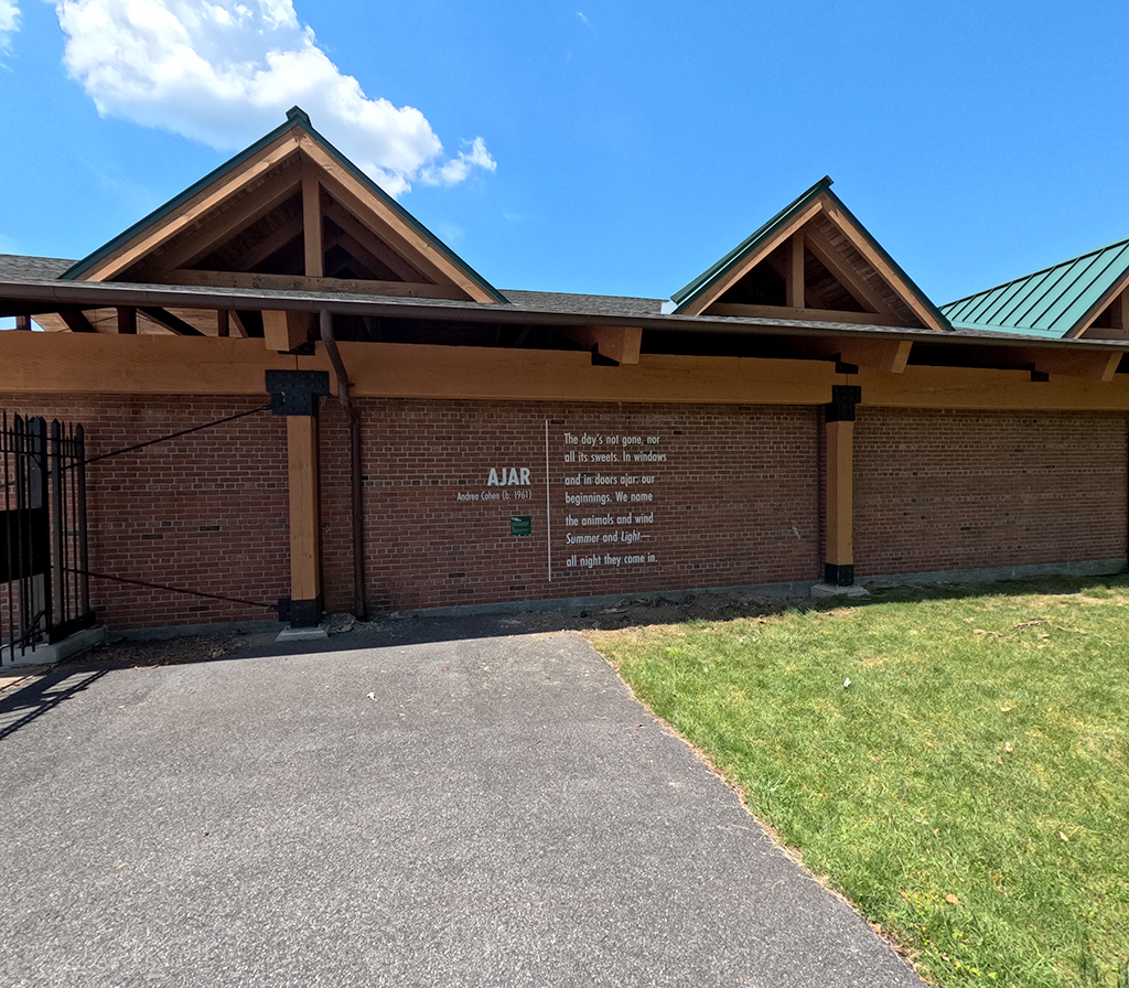
If you’re visiting a New York State park or historic site in the Hudson Valley this year, you might have a poetic encounter!
New York State Parks, Recreation and Historic Preservation (OPRHP) is presenting a new temporary public art project, Poetry in the Parks, to celebrate the Parks Centennial. Poems selected by the Poetry Society of America (PSA) and OPRHP are installed in three New York State parks and one historic site stretching from Westchester to Columbia County.
ClermontFDR State ParkLake TaghkanicWalkway Over The HudsonWalkway Over The HudsonThe five poems of the inaugural Poetry in the Parks installation.
This inaugural installation of Poetry in the Parks includes works by Andrea Cohen at FDR State Park in Yorktown Heights; U.S. Poet Laureate Ada Limón and New York Poet Laureate Patricia Spears Jones at Walkway Over the Hudson State Park in Highland and Poughkeepsie; Robert Hass at Lake Taghkanic State Park in Ancram; and Ishion Hutchinson at Clermont State Historic Site in Germantown. Integrated with the architecture found in the parks, the selected poems are meant to be discovered by visitors to help them reflect on the beauty of their natural surroundings.
When it comes to planning a vacation or getaway, New York State Parks has overnight options for all kinds of adventures – and budgets!
While some enjoy sleeping in tents away from it all in remote, natural settings under the stars, others crave a few more amenities. Whether you prefer booking rustic cabins and bringing your RV, staying in fully equipped cottages, or resting your head at a historic inn or resort with the comforts of home, State Parks has something for everyone.
Our Parks system includes 8,148 campsites, 967 cabins and cottages, 18 yurts, three inns, and – yes – a lighthouse. There are countless adventures for every type of stay. Get a map handy and explore highlights from some of our most interesting properties to inspire your next stay.
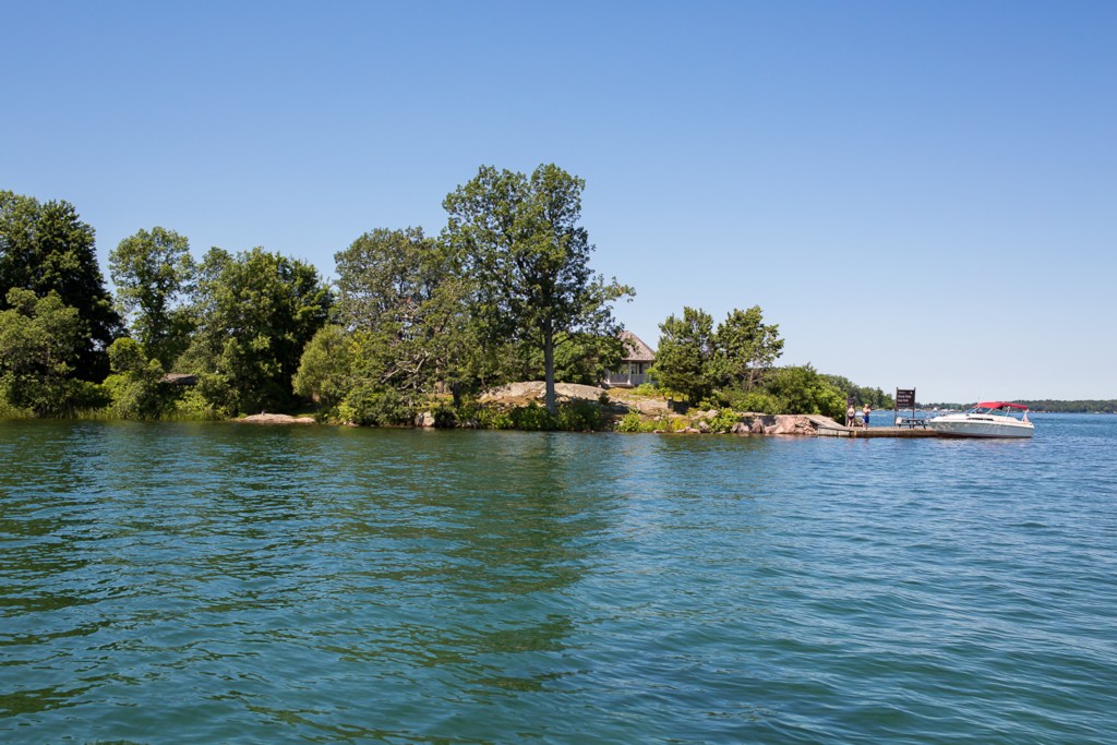
La Isla Bonita
If you have a boat or have access to renting one, answer the siren song of the water and consider the benefits of staying on one of three island parks in the Thousand Islands that are only accessible by boat.
Why worry about clearing your campsite for the tent when you can enjoy a level platform? Platform camping provides a wooden deck floor for pitching your tent on a smoother and more even surface.
A camping deck inLake Taghkanic State Parkin Ancram.
The perfect place for a family reunion on the Great Lakes? Check. Lakefront luxe in the Finger Lakes for a bachelorette wine-tasting weekend? Check. Thousand Islands waterfront cabin for anglers telling fish tales about the day’s catch? Check. Memories to last a lifetime? Check, check, check.
Robert Wehle State Park’s cliffside compound, Thousand Islands region.
Robert Wehle State Park features a private setting that accommodates eight, and includes a compound with a main house, guest quarters, studio, and formal gardens set cliffside along the Lake Ontario shorefront.
A cabin porch at Betty and Wilbur Davis State Park in Schenevus near Cooperstown.
Fans of America’s pastime can stay at a cottage at Betty and Wilbur Davis State Park near Cooperstown and head to the National Baseball Hall of Fame, then go old school and listen to a game on the radio from the cottage’s front porch.
Thanks to a “hands-on” kayak mission against invasive water chestnut this summer at Lake Taghkanic State Park, this popular lake ought to be clearer of these aquatic invaders for next paddling season.
And timing is critical in dealing with water chestnuts, floating plants which can rapidly spread to create dense patches that can clog a lake, damage the native ecosystem and make it hard for canoeists and kayakers to paddle.
Water chestnut (Trapa natans) is one of the several Aquatic Invasive Species (AIS) that are monitored in hopes of reducing abundances in state waterbodies. Widespread in the state, water chestnut is now found in 43 counties.
The aquatic invasive water chestnut can be found in 43 countries across the state. Counties shaded green are known to be infested. (Photo Credit – NYS Department of Environmental Conservation)
Invasive species, like water chestnuts, are organisms that are non-native to an area, typically causing harm to human health, the economy, and the environment. If left unchecked, AIS can spread quickly from one body of water to another, threatening biodiversity and potentially impeding recreational opportunities.
The key to battling the an infestation discovered this season at Lake Taghkanic in Columbia County was to remove hundreds of plants before going to seed. Water chestnuts are annuals, and thus must reseed themselves each year to propagate.
Anyone who has been out along a shoreline and came across a strong, spiny, star-shaped brown nut-like “fruit” or seed pods has found a water chestnut nut. Bearing four sharp spines or points, each nut contains a single seed that can produce 10 to 15 stems.
Anchored to the water bottom, the plants have submerged, feathery brownish leaves on stems that can grow up to 15 feet long. On the water’s surface, these stems come to an end with a floating rosette, or circular arrangement of leaves. The leaves are triangular shaped with toothed edges.
These clusters can float on the surface due to buoyancy bladders connected to the leaf stems, forming dense floating mats that can be nearly impenetrable. Each rosette produces about 20 of the hard nut-like fruits in the late summer and early fall which, after dropping from the plant to the water bottom, lay in sediment over the winter to sprout in the spring
Left: The spiny nut that contains the seed is tough and sharp, and can hurt if stepped on. Another name for this is “water caltrop”, so called for a nasty, pointy Roman-era spiked weapon that was strewn along the ground to pierce the feet of soldiers and hooves of horses. Middle: The rosettes where the nuts form. Right: A rosette floating in the water. (Photo Credit – NYS DEC)
You can imagine the concern when water chestnut showed up in Lake Taghkanic State Park, a park focused on boating, swimming, water sports and beach activities. Controlling water chestnut at the park was vital to support these recreational opportunities as well as the native fauna of the lake, including one rare species known there.
Due to the fast-growing nature of water chestnut, it is important to control newly introduced infestations as soon as possible, also known as “early detection, rapid response” (EDRR). If left unchecked, patches of water chestnuts can spread prolifically.
A map of Lake Taghkanic, showing the area of water chestnut infestation highlighted in green. (Photo Credit – NYS Parks)
Water chestnut is an invasive species of high concern for many waterbodies in New York State, having potential ecological, economic and health impacts. The plant can form dense mats on the water’s surface, greatly impacting the organisms below. These layered mats can block sun and oxygen from submerged plants, resulting in a die back of native species and fish populations. Recreation is also inhibited by dense patches of water chestnuts, making it difficult to swim, boat, kayak, or fish. The spiny nuts often drift to shore, creating an additional hazard for pets and people to step on.
Effective control of water chestnut depends largely on preventing seed formation. By manually removing the plants in mid-summer before mature seeds can drop, managers can halt such potential reproduction.
At Lake Taghkanic, staff from the Office of Parks, Recreation and Historical Preservation, state Department of Environmental Protection, and Capital Region Partnership for Regional Invasive Species Management (PRISM) worked to rapidly respond to the infestation. This team of ten individuals were well-versed in the control of invasive species, and several team members had prior experience manually removing water chestnut.
Held July 16, the pull was led by Matt Brincka (NYS Parks Invasive Biologist), with other participants including Falon Neske (NYS Parks), Lindsey DeLuna (NYS Parks), Lauren Gallagher (NYS Parks), Rebecca Ferry (NYS Parks), Kristopher Williams (Capital Region PRISM), Lauren Mercier (PRISM), Lauren Henderson (PRISM), Steven Pearson (DEC), and Catherine McGlynn (DEC).
The team navigated to the water chestnut infestation in kayaks, maintaining social distancing and wearing face coverings when necessary. When manually pulling water chestnut plants, it’s important to reach as far down the stem as possible to pull the root system from the bottom sediment.
At Lake Taghkanic, water chestnut was mixed in among lily pads, presenting a challenge to pulling by hand from kayaks. (Photo credit – NYS DEC)
In the bag: The rapid response crew has filled plastic bags with about 100 pounds of water chestnuts, each one pulled by hand from the lake bottom. (Photo Credit – NYS DEC)
Once pulled, the water chestnuts were collected in garbage bags, drained, and weighed. Within a day, more than 100 pounds, or from 300 to 400 plants were removed! The information was recorded for upload to iMapInvasives so that the infestation of water chestnuts can be tracked.
You may have heard the name iMapInvasives before, but if you have not been exposed to this magnificent mapping tool, I recommend you check it out! iMapInvasives, New York State’s online invasive species database, could be compared to a modern-day hero. A robust and helpful resource- thanks to its devoted observers. Citizen Scientists, Educators, Students…
Afterward, the team also surveyed the 3.7 mile lakeshore to ensure there were no other visible water chestnuts. Parks staff developed a control plan that will include monitoring and hand-pulling at Lake Taghkanic annually in order to deplete the seed bank (seeds can remain viable for several years at the bottom) and keep the problem at bay.
Over the years, NY State Parks has organized and participated in several invasive species pulls, additionally having a seasonally staffed AIS Strike Team and Boat Steward program. Reader more about these programs in the posts below.
Selkirk Shores State Park has been one focus area for State Parks staff in efforts to control a water chestnut infestation. In 2015, about 240 bags of water chestnut were removed there, visibly reducing the biomass by 40 percent. During the 2016 season, another 12.5 tons were pulled out. This removal resulted in a decrease in abundance of water chestnut during from 2017 through this year, further maintaining the value of this State Park.
Prompt invasive species responses, such as water chestnut pulls, work towards ensuring recreational enjoyment and preserving natural ecosystems in our parks. Early detections of invasive species are often reported by patrons.
The next paddling season may be months away, but remember: If you believe you have found a new population of an invasive species at a State Park, tell a park staff member or reporting it in iMapInvasives will ensure that swift eradication action is taken.
You may have seen them in a park near you, these super heroes and heroines in disguise. Since 2008, New York State Parks have deployed Invasive Species Strike Teams. These Strike Teams conduct invasive species surveys and manually remove non-native invasive plants in areas of significance. The goal is to protect native plant and animal…
Now that summer is here, when you head to the boat launch for a day on the water, you will often run into a friendly face in a blue vest. These are Boat Stewards! Boat Stewards are educators who share their knowledge of invasive species and how to prevent boats from spreading such species into…