Tag Archives: Taconic State Park

Ready At The Rope

It was going to take heavy ropes and safety gear to rescue a 75-year-old man who was hurt and bleeding after falling near the rocky summit of Dutchess County’s highest point — 2,316-foot Brace Mountain.

With temperatures above 90 degrees and humidity thick that July 4th weekend afternoon, crews at Taconic State Park faced a half-mile hike up the mountain to reach the victim, who could not walk after injuring his head and extremities in a fall on a steep trail.  Initial reports also indicated the man was on blood thinning medication, which could make his bleeding harder to stop.

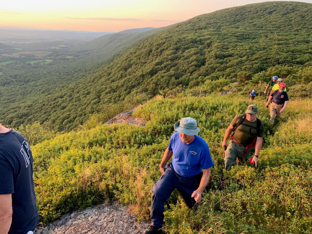
Setting out from the trailhead, the crew included myself, members of the local Millerton Volunteer Fire Department, an emergency medical technician, two forest rangers from the state Department of Environmental Conservation, and members of the Northwest Connecticut Rope Rescue Team. With about 300 pounds of ropes and hardware for the crew to carry, the hike in took about 45 minutes.

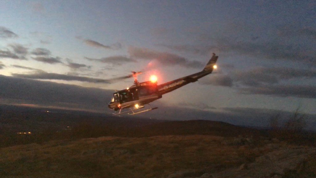
Some five grueling hours later, crews had carried and lowered the 125-pound victim hundreds of feet down the mountain, with the help of the stout ropes, a metal basket, and a piece of equipment called a stokes wheel. A stokes wheel is a single ATV tire that clips to the sides of a metal rescue basket, making transportation on rough terrain more comfortable for the patient and easier on rescuers. The victim was then airlifted to a local hospital with non-life threatening injuries.

Using a stokes wheel, the rescue crew carries an injured hiker down Brace Mountain.
A helicopter heads to Brace Mountain to extricate an injured hiker.

This is not the first occurrence of this type of injury on this trail. Earlier that year, a hiker had fallen on the icy trail and injured his ribs, requiring rescue crews to carry him out on a stokes wheel. A few years earlier, another visitor fractured his leg while slipping on leaves and was airlifted off the summit of Brace Mountain after being carried by crews for more than a mile to a suitable landing zone.

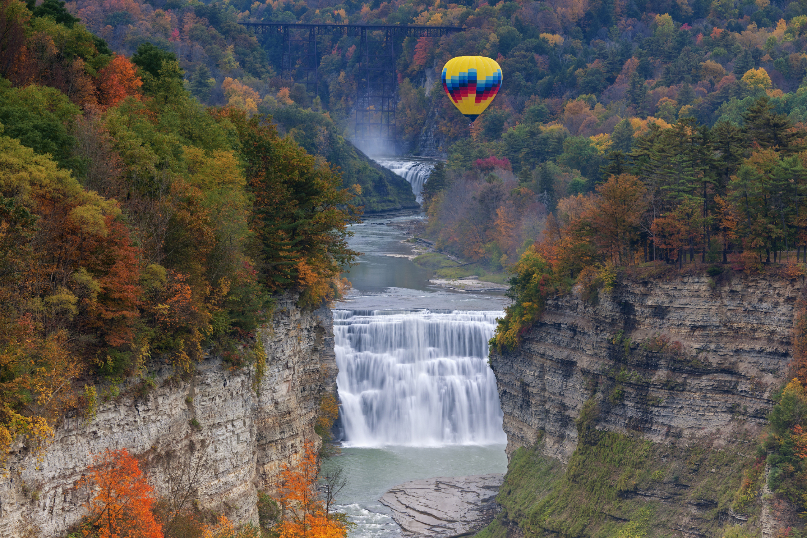
As park attendance continues to rise, and social media convinces more potential hikers to head for the backcountry, we are seeing an increase in patron injuries and so-called ‘technical’ rescues in our State Parks. Such rescues are becoming more common at places like Taconic State Park and Hudson Highlands State Park in the Taconic Region, Minnewaska and Bear Mountain State Parks in Palisades Region, John Boyd Thatcher in Saratoga Region and Letchworth State Park in Genesee Region.

People fall while taking selfies, slip while wearing improper footwear, or enter hazardous and closed areas of our parks. Some patrons fail to dress for the weather, do not bring flashlights or maps, fail to bring enough water and are generally unprepared to hike some of the terrain our beautiful parks offer. The mighty cell phone has made many of our patrons more confident knowing help is only a call away. This false confidence has started to put a strain on park resources along with surrounding first responders who are constantly being called to parks for injuries, and search and rescues.

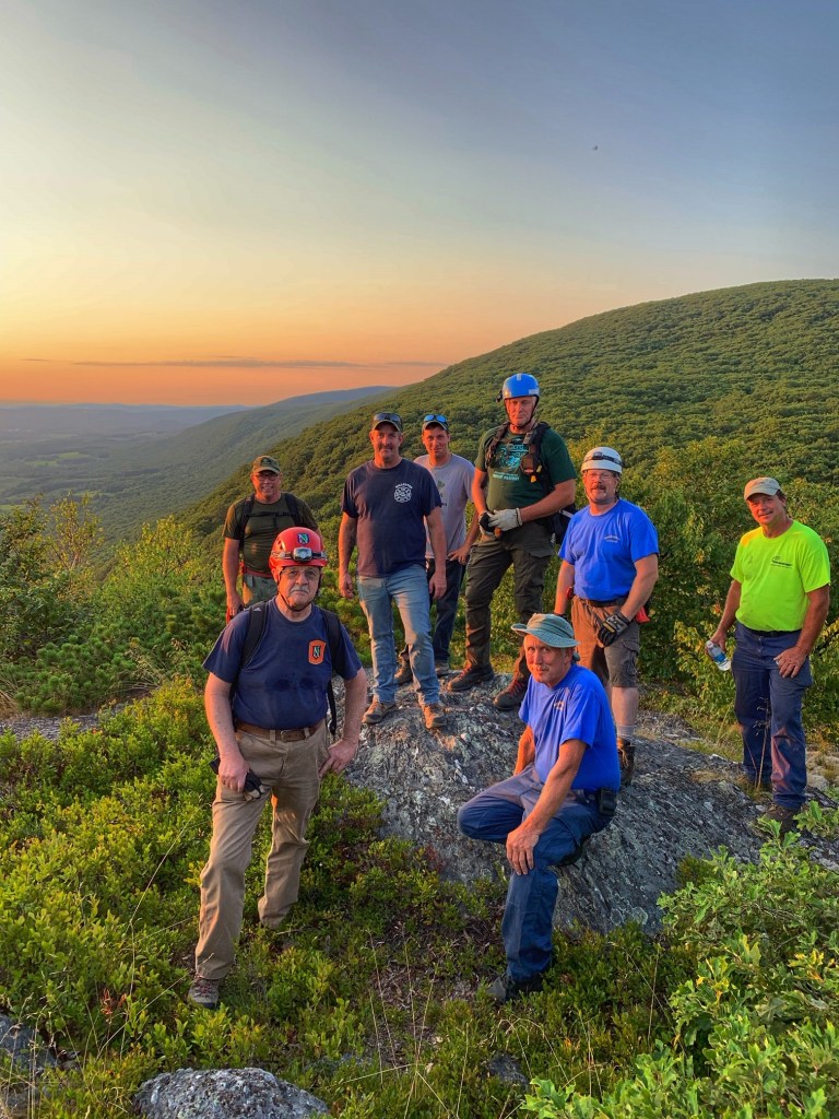
In order to work better together and streamline communications between rescue crews, here at Taconic State Park we have started annual rope rescue drills with local fire departments, forest rangers, rope rescue teams, park police and other first responders.

The drills include using Incident Action Plans and the Incident Command Structures we all learn in our classes as park managers. By drilling, we get to practice putting together planning documents and working with Incident Commanders who coordinate with park officials on such emergencies. We gain valuable facetime in a non-emergency atmosphere where we can dissect our pre-planning and offer each other suggestions and advice.

In late October, staff at Taconic State Park held a Joint Rope Rescue drill that brought together over a dozen responding agencies from two states and three counties. The drill was a mock exercise that practiced communication between different departments, navigation and various rope rescue skills and strategies.

Members of the Brace Mountain Joint Rope Rescue Drill in October.
A map of the Brace Mountain region used during the safety drill.

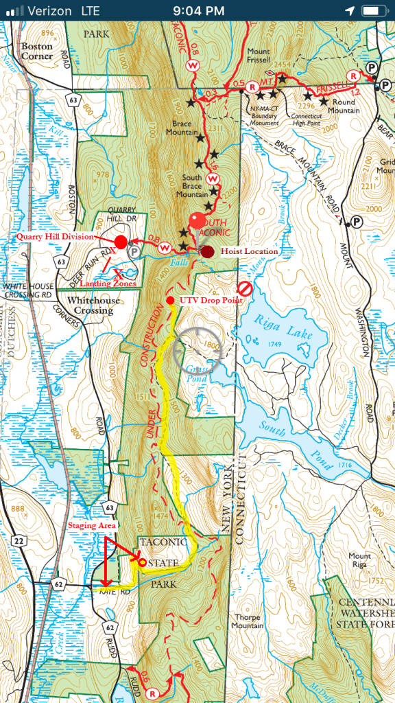
We also review our rescues to learn not only what we did right but more importantly, where we can improve. One lesson from the July 4th incident is that we will now use staging areas for motorized UTV’s that shuttle rope gear to a pre-planned location near the summit of the mountain so that heavy equipment no longer needs to go uphill with rescuers on foot.

By using motorized vehicles to bring heavy gear above where a rescue has to happen, rope crews only have to carry this equipment downhill, which saves more of their energy for when they reach a victim. It takes a few more resources to do this but ultimately increases the efficiency of getting equipment to the injured hiker.

Also, we have established multiple hoist locations in the area, so if available, a helicopter can save us the time and effort of carrying and building lowering devices with ropes and hardware in the field. This will not always be available, but it is another tool that we can use to make rescues faster and safer.

All parks are required to have an All Hazards Emergency Action Plan. However, some emergencies in our parks require more planning than the normal fire drill or patron with heat exhaustion. Some potential emergencies require park managers to meet with local first responders on a regular basis to enhance the speed and efficiency of their response.

No matter what size the park or historic site, it is always essential to have an open line of communication with the local fire chief, rescue squad and Park Police so that the one day they are needed, they know your face and who you are. It just makes things easier – and ultimately safer – for the thousands of visitors who use the trails in the rugged regions of our State.


Post by Chris Rickard, Park Manager, Taconic State Park


Prepare To Help Avoid Accidents

  • For a safe hike, there are things to remember beyond carrying a mobile phone. Wear sturdy yet comfortable shoes or boots, and bring water and snacks for the trail. Wear clothing appropriate for the weather.
  • Be mindful during hikes on steep terrain or that go near cliff tops. Hiking poles can help stabilize yourself against a potential fall, and transfer stress of hiking from your knees and legs to your arms and back.
  • In the winter, when snow and ice can cover trails, carry and use traction gear on boots, such a webbed spikes or crampons.
  • Carry a small first-aid kit in case of emergency. Hike with a partner, so if something happens, help is present. Hiking alone is risky.
  • Use a trail map, which is available online at each park website at https://parks.ny.gov/ and at the main office at each park, in season. Check the park’s individual website to see if its maps can be downloaded to your iOS Apple or Android device, but a paper map is a good backup in the event of device failure.
  • For some facilities, data is available as a Google Earth KML file or a map is available to download to your iOS Apple and Android mobile devices in the free PDF-Maps app. Learn more
  • Once you have a map, you can tell how long a trail is and how long it ought to take to finish. As days grow shorter in fall and winter, having a flashlight or headlamp in your backpack is a good form of insurance, should you unexpectedly find yourself on the trail as dusk approaches.
  • If issues arise, be prepared to turn around. Don’t fall victim to “summit fever” – the desire to reach the top regardless of the risk.
  • And, as incidents of tick-borne diseases surge in the state, it is always important to check yourself for ticks after being outside during spring, summer and fall, even if it is only time spent in your own backyard. Thankfully, ticks are not normally active during the cold of winter.
The Brace Mountain rope drill team nears the summit.

All pictures courtesy of NYS Parks

Get out and explore … the Taconic Region of State parks

With more than 2,000 miles of marked trails across New York, the State Parks have something for hikers of every ability. That includes the beautiful Taconic Region, located on the east side of the Hudson River and stretching through Columbia, Dutchess, Putnam and Westchester counties.

Palatial estates, highland trails, Hudson River vistas and woodland campgrounds define some of the exceptional treasures to be found in a region with 14 parks and eight historic sites.

If you are new to hiking or have not yet explored hikes in this region, named for the Taconic Mountain range that runs north-to-south along the state border with Connecticut, Massachusetts and Vermont, here are some suggestions to start you out.

As with all hikes, there are few things to remember beyond carrying a mobile phone. Wear sturdy yet comfortable shoes or boots, bring water and snacks, and perhaps carry a camera, to capture what you see. Be mindful of hikes on steep terrain or that go near cliff tops. Having a small first-aid kit available in case of emergency is never a bad idea.

Hiking poles are useful, and can transfer some of the stress of hiking from your knees and legs to your arms and back. And use a trail map, which is available online at each park website at https://parks.ny.gov/ and at the main office at each park. Check the park’s individual website to see if its maps can be downloaded to your iOS Apple or Android device.

These maps include Park facilities such as parking, park offices, nature centers, campsites, and boat launches in addition to the location, name and distance of each designated trail in the park. For some facilities, data is available as a Google Earth KML file or a map is available to download to your iOS Apple and Android mobile devices in the free PDF-Maps app. Learn more

It never hurts to know how long a trail is and how long it ought to take to finish it. Since daylight is not an unlimited resource, tossing a flashlight or headlamp into your backpack is a good form of insurance, should you unexpectedly find yourself on the trail as dusk approaches.

Westchester County

Rockefeller State Park Preserve, 125 Phelps Way, Pleasantville,  (914) 631-1470: With 55 miles of crushed stone carriage roads that crisscross the former country estates of petroleum tycoons John D. Rockefeller and William Rockefeller, the preserve offers a wide variety of hikes for any ability, with the carriage trails offering a consistent, predictable surface. After parking at the preserve office, follow the markers for Brother’s Path, a 1.1-mile loop around scenic Swan Lake. Heading south on the Brother’s Path, there a connection on the right to the .9-mile Overlook Path, a gentle climb and a good place to spot Eastern Bluebirds and get a beautiful view of Swan Lake. The preserve is home to more than 180 different species of birds and 120 different species of native bees.

Maps here

Rockefeller State Park Preserve in Pleasantville.

Franklin D. Roosevelt State Park, 2957 Crompond Road, Yorktown Heights, (914) 245-4434 : This is a short hike in the woods on level terrain leaving to a small pond. From the parking lot for the swimming pool, take the white-marked trail, turning onto the blue-marked, 1.2-mile trail for Crom Pond. At the end, turn around, or continue on the orange-marked, .7-mile Mohansic Trailway through more woods before turning around.

Maps here

Franklin D. Roosevelt State Park in Yorktown Heights.

Putnam County

Fahnestock State Park, 1498 Route 301, Carmel,  (845) 225-7207: Hike, sunbathe and swim all at one location. Start at the Canopus Beach Parking Lot, where you can pick up the blue blazed AT Connector Trail from the north corner of Canopus Beach. A short 0.3-mile hike passing along the edge of Canopus lake will lead you to the famous Appalachian Trail. Turn right and take the white blazed AT trail northbound. A steep section of trail will lead you to a beautiful viewpoint over Upper and Lower Canopus lakes. Continue north and after one mile on the AT turn right and head south onto another blue blazed AT connector trail. A rolling 0.75-mile hike will lead you back to the Canopus Beach Parking Lot and all the other activities.

Maps here

The view from the South Taconic Trail, looking toward Mount Brace, at Taconic State Park in Millerton/Copake Falls.

Mills Norrie State Park, 9 Old Post Road, Staatsburg, (845) 889-4646: This park has a very scenic hike along the Hudson River. Turn onto Norrie Point Way and follow signs for the Marina, where you find signs for the White Trail. If you brought a kayak or canoe, you can put it into the river there. The White Trail is approximately two miles long and and leads to Staatsburgh State Historic Site, the elegant 65-room country mansion of Ogden Mills and his wife Ruth Livingston Mills. You can choose to take the White Trail back along the river, or the Blue Trail. Along this wooded trail you can view the historic Hoyt House and Carriage Barns. While at Staatsburgh, catch a view of the 148-year-old Esopus Meadows Lighthouse on the river. If you plan to visit by boat, the Mills Norrie State Park marina has 145 boat slips.

Maps here

Kayaking on the Hudson River in Mills Norrie State Park.

Columbia County

Lake Taghkanic State Park, 1528 Route 82, Ancram, (518) 851-3631: Start at the parking lot at the swimming beach, and pick up the white-marked Lakeview Trail, which goes about 5 miles around the lake but is not a loop. It can be hiked as an out-and-back by going either north or south on the trail, which is mostly level and good for all abilities.

Maps here

Picnic tables along the trail at Lake Taghkanic State Park.

There is a full list of activities this month at State Parks and Historic Sites in the Taconic Region. It can be found here

Keep an eye on the NY Parks Blog in coming weeks as we explore hikes in the ten other State Parks regions… Do you have a favorite to share?

Fall in Love with Autumn Camping

If you think camping in a state park campground is enjoyable in the summer, wait until you experience an overnight getaway in September or early October, when New York’s outdoors is awash in enough colors and sounds of the season to overwhelm the senses.

The autumn mist rising from the water’s surface on a brisk morning, paddling along a tree-lined shore edged in spectacular reds, oranges and golds, the crunch of leaves underfoot on a hike, the aroma of coffee over a crackling fire — these are just a few of the experiences awaiting those campers who prefer to camp once the crowds thin, schools are back in session, and Labor Day is in the rearview mirror.

Benefits to fall camping include fewer neighbors, fewer bugs, and a greater selection of sites from the peak summer season.  With the right clothes and gear, the slightly cooler temperatures make fall camping more comfortable than in the commonly muggy dog days of summer.

Plan to extend a leaf-peeping day trip and sleep under the autumn stars. You can book ahead to reserve a spot or opt for a spontaneous adventure and just grab your gear and go. Many state park campgrounds throughout New York are still open with availability for tent and trailer sites, yurts, cabins, and cottages.

Here are just a few of our fall favorites:

Red House CG, Fall Camping
Listen to the rustling leaves while you camp at Allegany State Park, photo by State Parks.

At 65,000 acres, Allegany State Park is the perfect setting for embracing nature’s colorful palette in the fall months.  Lakes, ponds, and miles of trails, beckon outdoor lovers for hiking, biking, nature walks, fishing, paddling, and more.  Choose from tent and trailer sites, cabins, and cottages.

The Middle Falls At Letchworth State Park
Ballooning at Letchworth State Park, photo by Jim Vallee.

In the Genesee Valley, the sweeping views at Letchworth State Park are jaw-dropping in every season, but add vibrant foliage to the mix and prepare to be amazed by the sheer grandeur.  For campers, the park offers tent and trailer sites and cabins.  Visit the new Humphrey Nature Center or explore the gorge trail on your own — views from Inspiration Point and Middle Falls are a must-see.

Taughannock Falls State Park _DSC_0001
Enjoy the waterfalls at Taughannock Falls State Park, photo by State Parks.

The Finger Lakes gorge parks also provide a stunning backdrop for camping this time of year.  Take a break from campfire cooking and enjoy the bounty of farm-to-table restaurants or the premier wineries in the area. Home to 19 waterfalls, Watkins Glen State Park on Seneca Lake welcomes campers to an array of wooded campsites (many with electric hookups) and rustic cabins.  Walk along the winding paths of the gorge or take a bike ride on the nearby Catharine Valley TrailTaughannock Falls State Park on Cayuga Lake leaves visitors spellbound with its namesake waterfall and rocky cliffs that perch high above the gorge.

Green Lakes (15)
Fall camping with a furry friend at Green Lakes State Park, photo by State Parks.

The only thing more colorful than the fall foliage at Green Lakes State Park is the actual Caribbean-like hues of the glacial lakes themselves.  With campsites nearby including many full-service sites and renovated cabins, campers also have easy access to the park’s 20 miles of hiking trails and championship golf course.

Moreau Fall_0011-12 copy
If you camp at Moreau Lake State Park, take a hike around the lake, photo by State Parks.

Moreau Lake State Park is situated in the foothills of the Adirondacks with tent and trailer sites, cabins and cottages. Hike or bike on the 27 miles of trails and enjoy paddling and fishing on the scenic waters of the park’s beautiful lake or the Hudson River.  Wildlife viewing is a favorite!

Copake Falls Campers_JR2432email
Autumn campers at Taconic State Park, photo by State Parks

Taconic State Park offers autumn campers incredible sites for tents or trailers, cabins and cottages, and plenty to see and do including biking, hiking, fishing, paddling, and more.  As part of the adventure, be sure to check out the Harlem Valley Trail, the South Taconic Trail, Bash Bish Falls, and the Copake Iron Works Museum.

Bennington Battle Feild Fall DSC_0122b
Fall colors at Bennington Battlefield State Historic Site, photo by State Parks

Tip:  Whether planning a fall camping adventure or taking a leaf-peeping day-trip, a good resource to determine peak color location is the I Love NY Fall Foliage Report issued weekly.