Image 1, Bobcat, Terry Spivey, USDA Forest Service, Bugwood.org
Many animals live in the Northeast, including wild felines like bobcats (Lynx rufus) (Image 1). Once heavily hunted for their prized and beautiful fur coats, the remarkable American bobcat (Lynx rufus) population has recently rebounded in the Northeast. This remarkable feline resides in young forest and shrub communities along wetlands and along the shrubby areas next to agricultural fields. Recently, bobcats have expanded their home range to mature forest communities of oak-beech-hemlock. In doing this transition to new habitats, the bobcat added young deer, squirrels, and chipmunks to their diet of beaver, muskrats, rabbits, and rodents but also young deer, squirrels, and chipmunks. Like all felines, these hunters will be found “hiding” among shrubs, tree branches, on ledges, or even laying down as flat as possible on the ground. Their fur pattern and coloration, like all cats, acts like camouflage and helps the bobcats hide in the surrounding environment while stalking prey or taking a nap.
Identification
Several wild feline species, including bobcats, either make their home or once made their home in New York. The Canada lynx (Lynx canadensis) (Image 2, left) have made a presence and have been observed hunting or hiding among the far northern forests of New York. Eastern mountain lion or cougar (Image 2, right) have been absent from much of their eastern range, including New York State for nearly two hundred years. In the western states Mountain Lions have a secure presence while in the Everglades and Big Cypress Swamp of Florida their presence is much smaller.
Image 2, Canada lynx, photo by Michael Zahra
Image 3, Cougar (mountain lion or catamont), public domain image.
Characteristics
All cats have a distinct look – predatorial eyes located in front of their heads with upright ears. Like our domestic cats, New York felines have tails, some are just shorter than others. Bobcats have either short stubs on their behinds or shortened tails. The bobcat also has a white behind that traces up to the underside of the tail and has a darkened tip.
The lynx always has a short, stubbed tail and a distinct black cap on the entire tail tip.
Ear tufts are present on both lynx and bobcat. Tufts of the bobcat are shorter than a lynx, or they may not be present at all. Lynx, on the other hand, will always have the distinct black tufts on top of the ears. Bobcats tend to have some black-brown-grey pattern or variation in colors compared to the more streamlined tannish-grey color and white chest of the lynx. Lynx also are notably wearing Elizabethan bowtie-like ruffs with black tips, which are lacking in the other two cats. Coloration of the hock, or the portion of the hind leg below what we commonly associate as the joint, are different in bobcats and lynx. Bobcats have black, dark brown, or dark grey. The hock of a lynx is not a dark color but rather an extended, continued coloration of their body. Lynx also have white on the insides of their legs.
Cats walk with an athletic stride and cautiously stalk their prey while hiding from plain sight.
Image 4, Image above compares mountain lion, lynx, and bobcat pawprints. image courtesy of Catskill Mountaineer
Pawprints
If you were to place your hand on paint and press on a surface, a hand print would form showing your fingertips and palm. Just like our hand prints, all feline paw prints would also show their tips and a palm as shown in Image 4. The size and height of our fingers differ and so do the paw tips of cats (Image 4). In cat paw prints, we find four paw tips at different heights above the “M” shaped palm print. Cat lead finger is similar to our middle finger print, which would be at the highest height of the paw. The pinky would be the smallest print and at the lowest height, as would our pinkies. We would see the last other two cat paw tips varying in height and size as we would find the ring finger and the pointer finger vary our finger prints. Also, distinct with cats is the formation of a circle around the tips and palm that results from the fur on the paws. This shape is very distinct with the lynx as shown in Image 5 as a print inside this circle.
Image 5, Image above taken by JLS Photography – Alaska showing the distinct circular fur outline around the lynx’s pawprint.
Generally, the bobcat pawprints are round and roughly a couple inches in the size. Lynx’s pawprints are twice this size. Lynx have a smaller diameter in their tip and “M” shaped palm prints and have greater spacing between the positioning of their tips and their palm. The reason for the smaller diameter and greater spacing between the tips and palm is due to the denser fur on the paws. The mountain lion has the largest pawprint, totaling 3 inches in diameter or larger. If you happen to see the felines in motion, note the paws of the lynx as being large, plush slippers in comparison to the bobcat.
Image 6
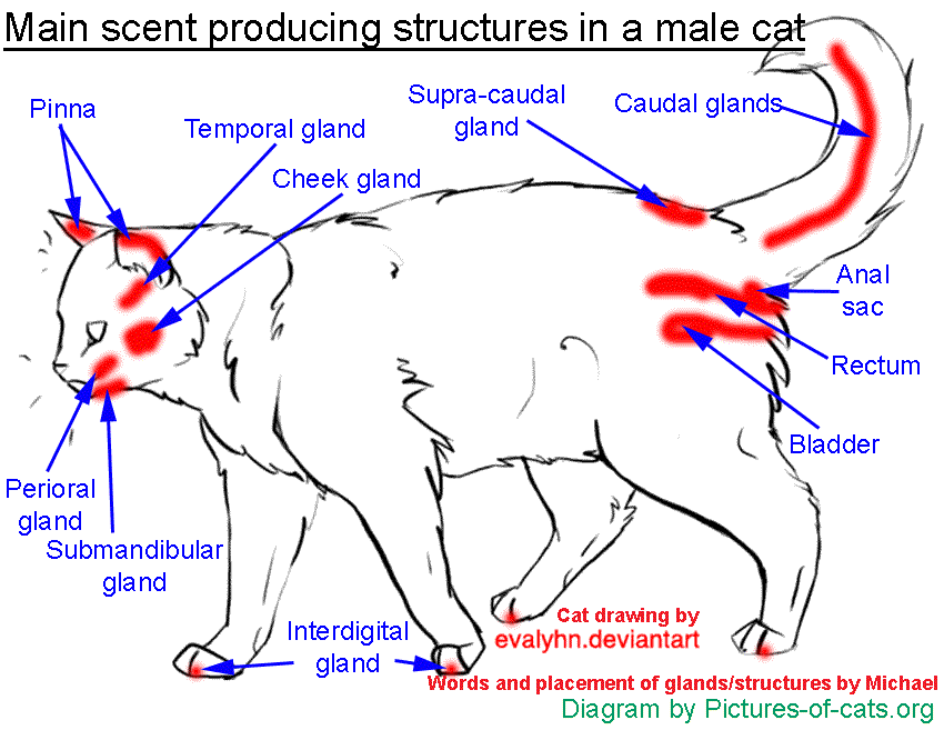
Territory Marking
Felines will mark their territory through scents. Just like our domestic feline friends, bobcats, lynx, and mountain lions will rub their faces, scratch their paws, and even spray to mark their territory. Glands that produce a scent are found on the face, between the toes of the paws, and by the tail (Image 6). On the head, they are found at the base of the ears (pinna glands), on the eyebrows (temporal glands), on the cheeks (cheek glands), at the base of the whiskers (perioral glands), and at the base of the chin (submand ibular).
Scent marking is why the wild felines in the forest and your domestic cat rub their face all over trees, rocks, and other objects. Scratching vertically on trees, or furniture, and kicking their hind legs are common ways cats mark their scent on objects through the interdigital glands between their toes. Also, notably rubbing their bum on objects leaves scents from their anal glands (Image 7). Hair can also be left on trees, stumps, rocks, and other objects as the feline rubs. Looking for their presence through hair on objects, scratch marks on trees, or two strips of unearthed vegetation leading to a pile of material (Image 7 & 8). You can also sniff for a musky urine smell on the undersides of decaying or falling trees, limbs, branches, or ledges.
Finding evidence or seeing one of New York’s native cats can be quite a treat. If you do see a native cat, let us know!
Winter is a wonderful time of the year, there’s snow and ice everywhere in our State Parks. Within that snow and ice, you can see traces of what animals have been there – maybe even just moments before you arrive! One of the traces that can help you identify which animal it came from is their tracks.
To determine what animal the track came from, you should look at several different factors. First, the condition of the snow the track is in makes a big difference in how a track looks (wet snow leads to more clear tracks and drier, powdery snow has less clearly defined tracks). Second, you should think about the gait of the animal (how it moves). There’s four different types of gaits that most animals use in their daily activities: the walk, the trot, the gallop and the jump. And lastly, you must look at the shape of the track including the number of toes present, which can vary in size depending on the animal that made it. For more information on identification of winter tracks, please see this blog.
Let’s look at some tracks that have been seen throughout our State Parks:
Here’s evidence of a mink on the ice of one of the streams within Allegany State Park, photo by T. LeBlanc
This is the track of a long-tailed weasel also seen within Allegany State Park. Fun fact: long-tailed weasels have a very high rate of metabolism and they eat about 40% of their body weight per day! photo by Thomas LeBlanc
Above you can see track of a turkey. To learn more about Allegany State Park’s role in wild turkey restoration, please see this blog. photo by Thomas LeBlanc)
And a coyote track was spotted within Allegany State Park. As you can see, there is a bit of fur and a splotch of blood so perhaps this coyote just finished his lunch! Photo by Randall Abbott.
Within the Finger Lakes Region, park staff noticed this track of a fisher at Keuka Lake State Park. Photo by Becky Sibner
The tracks above, found at Harriet Hollister Spencer State Recreation Area, are from a deer. The large spot is where the deer had stopped to browse. Photo by Whitney Carleton
This is the footprint of a black bear, found at Mark Twain State Park. For more information on female black bears in the wintertime, please look at this blog. Photo by Kira Broz
Also, seen at Mark Twain State Park, is a raccoon. The most important sense of the raccoon is their sense of touch – they have hyper-sensitive front paws adorned with vibrissae (a type of hair that aids in tactile sensing) that allows them to identify objects before fully touching them! Photo by Kira Broz
At Letchworth State Park, you can see the tracks of a squirrel as compared to a human footprint for a scale reference. Photo by Gary Lamitina
Above is the tracks and wing impressions of a Northern Bobwhite, a small quail, seen at Connetquot River State Park Preserve on Long Island. Photo by Annie McIntyre
At Fort Montgomery State Historic Site, you can see the tracks of a squirrel and some mystery tracks as well…which turns out to be from a pine cone as seen in the insert! Photo by Peter Cutul
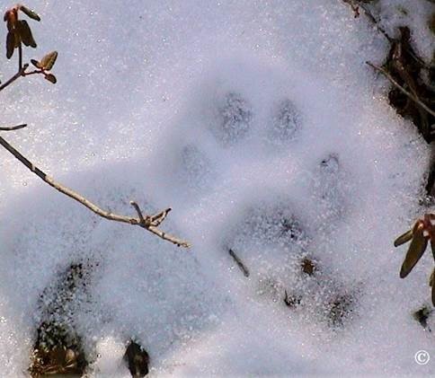
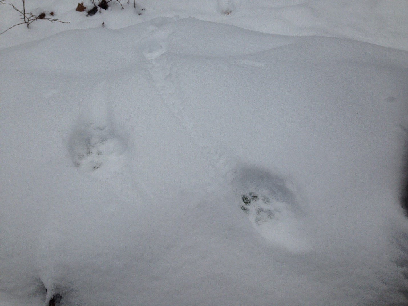
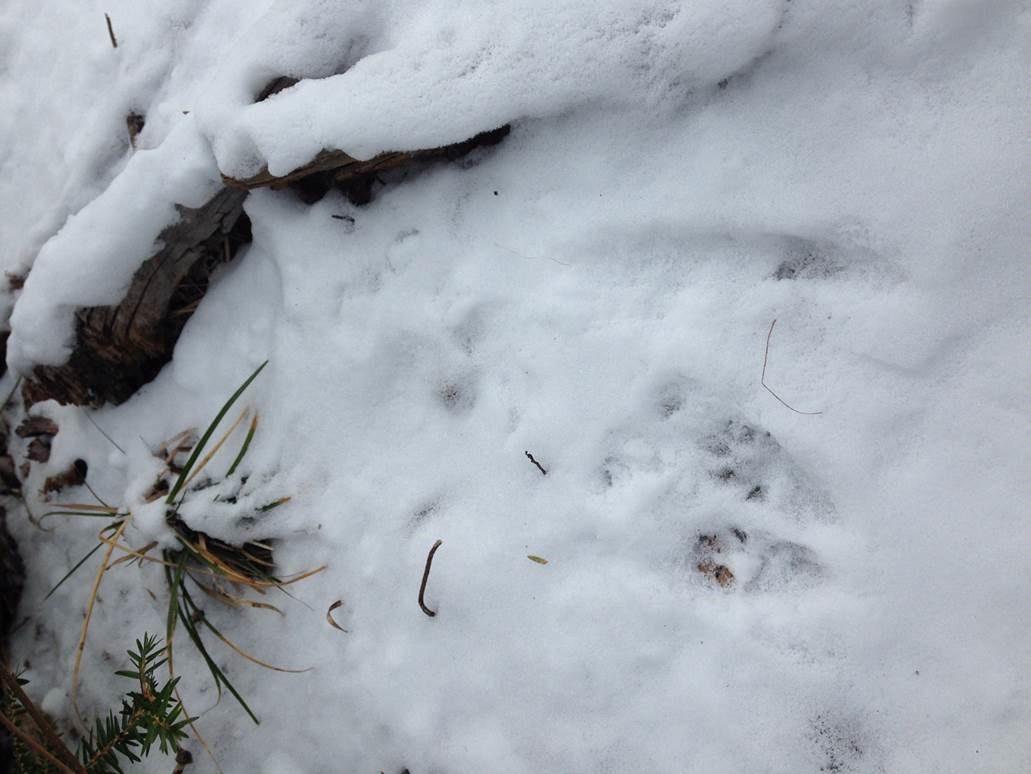
At Harriman State Park, you can find the tracks of a bobcat as seen here. For more information on bobcats and other wild cats of the Northeast, please check the blog again in a few weeks for the upcoming post on that subject! Photo by Peter Cutul
Also at Harriman State Park, the tracks of what is believed to be a short tailed weasel can also be found! Photo by Peter Cutul
Looking around Grafton Lakes State Park, river otter tracks can be seen in the snow. Photo by Elizabeth Wagner
As you can see, there is still a great diversity of animals to be found within our State Parks – even in the cold of winter! So, the next time you’re hiking the trails at a State Park, look around you and see what tracks you can see!
Scat is another trace that animals leave behind. If you are interested in learning more about winter scat ID, check out this blog.
Post by April Brun, State Parks
Disclaimer: All identifications are just suspected, none are confirmed by a wildlife biologist.
The wild turkey is native to North America, but suffered severe declines due to wide-scale forest clearing and over hunting. By the mid-1800’s, this great bird was gone from New York state and much of the northeast. However, in the mid to late 1940’s, some wild turkeys were observed along the NY and PA border from Allegany State Park to the Genesee River Valley, a sign that the habitat might be recovering and able to support them again. So, in the early 1950’s, the New York State Conservation Department (forerunner to the NYS Dept. of Conservation) began a restoration effort in the early 1950s. They started with game farm turkeys, but after a few years, this effort failed because the game farm birds were not wild enough to avoid predation and lacked the capacity to survive.
Flock of hens in the forest in the 1950’s.
Meanwhile, a healthy breeding population of wild turkeys expanded from Pennsylvania into the Allegany State Park region of New York. Park managers then gave the Conservation Department permission to trap turkeys in the park, initiating the wild turkey trap and transfer program which began in 1958 and concluded successfully in 1974. This program allowed for more rapid expansion of the turkey population to suitable unoccupied habitats.
Tom turkey displays his tail.
The turkeys trapped in Allegany State Park were moved to several areas in the Region and then throughout the state. In addition to the in-state trap and transfer, turkeys from the park were also sent to Connecticut, New Hampshire, New Jersey and Vermont. Other trapping efforts in the region and elsewhere in New York sent birds to Delaware, Minnesota, Rhode Island and the Canadian Province of Ontario. New York turkeys helped re-establish populations throughout the Northeast, Midwest and southeastern Canada.
Nets ready to trap a flock of turkeys.
Turkeys caught in a net.
Conservation Department staff and local volunteers place the turkeys into boxes. Afterwards, the birds were moved to their new homes.
New York State Conservation Department was one of the pioneers among state agencies to restore wild turkey populations in the United States. This program would not have been successful without the cooperation of Allegany State Park and to this day is recognized as one of the greatest wildlife management success stories of North America.
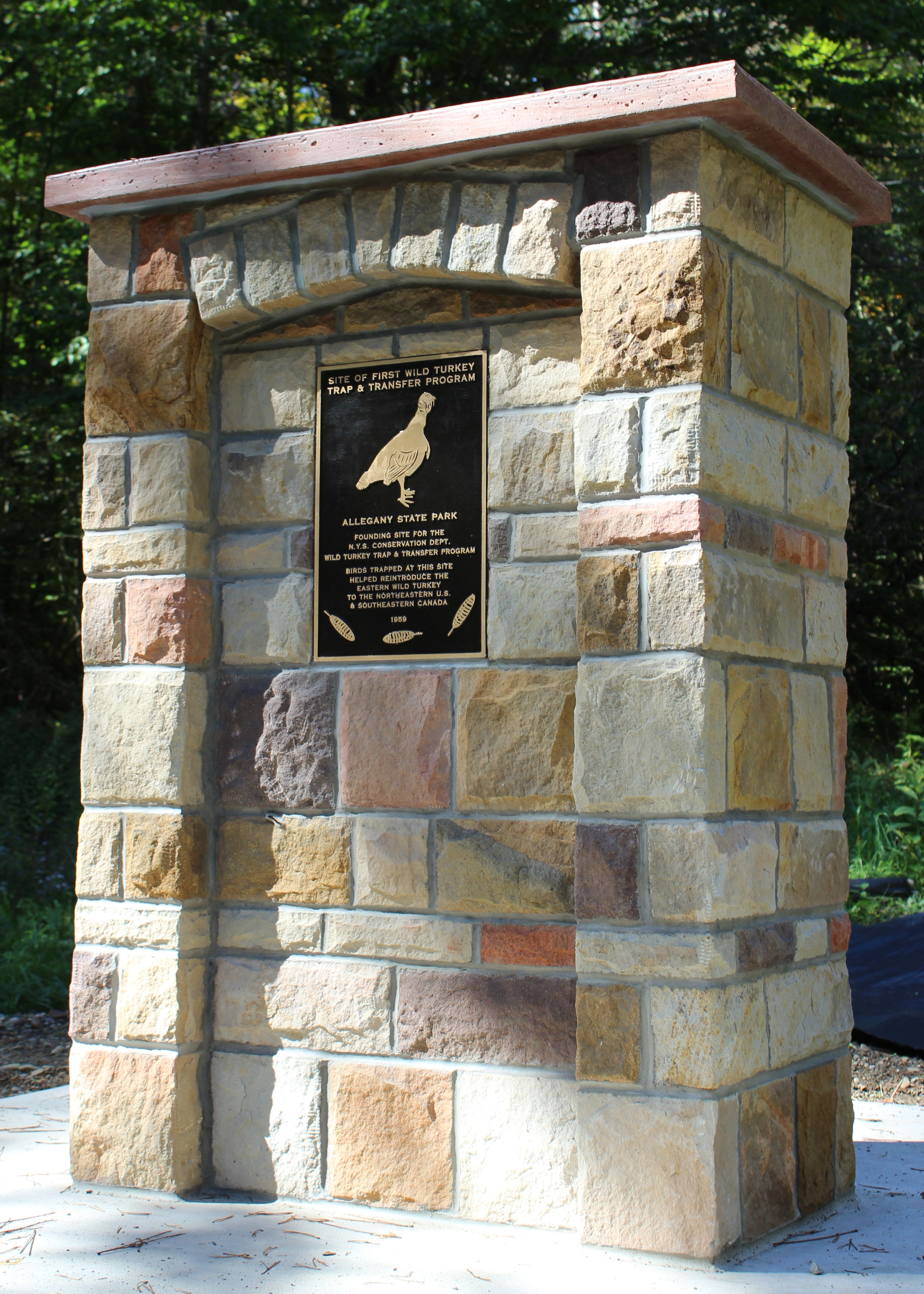
2017 Monument commemorating the first wild turkey trap and transfer program, photo courtesy of Rick Miller, Olean Times Herald
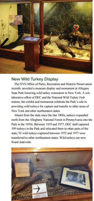
Wild Turkey Restoration exhibit in the Red House Natural History Museum, image from DEC Conservationist, October 2017, p 28.
When we think about spring and fall in the northeast, we often dwell on the extraordinary changes that occur to our trees and other plants. In the spring, we yearn for green to replace the barren gray and white of winter; in fall we marvel at the warm oranges, reds, and yellows that are on display as our trees prepare for winter. But there is an equally amazing change that is occurring at the same time, one we often fail to realize because we simply don’t look up: the mass migration of raptors. Whether it is the sheer majesty of a bald eagle, the raw power of a northern goshawk, the pure speed of the peregrine falcon, or the extinct-ness of the Velociraptor, raptors have captured the minds and imaginations of people and cultures for generations. Raptors, also called “birds of prey,” include eagles, falcons, hawks, vultures, ospreys, harriers, and owls.
Raptor-watching, normally referred to as “hawk watching,” is a great way to spend a spring or autumn afternoon and can be enjoyed in many of our State Parks. Hawk watching is a draw for both veteran and novice bird watchers alike. Raptors are highly visible during their migration as they soar through the skies, unlike songbirds who hide in dense shrubs and tree tops. If you go to popular hawk watching sites during migrations (www.hawkcount.org), you will often find other observers and official hawk counters. These fellow birding enthusiasts are always eager to help you identify the shapes and flight patterns of certain groups and species. With a bit of practice, you’ll be a veteran in no time!
Migration
Migration is no joke and (as you can imagine) can be exhausting. Some species, such as broad-winged hawks, travel over 4,500 miles in about 9 weeks. Why do these birds go through all this trouble, anyways? Your first guess might be that the birds are escaping the cold. However, if so, then why don’t they stay closer to the equator, where it is always warm? The suggestion that temperature triggers migration is a very common misconception and is often connected to human behavior. Many northerners head south for warmer climates to escape the winter chill. Those who spend their entire winters in the south are even given the name “snowbirds.” With bird migrations, they aren’t escaping the cold; they are often migrating due to the lack of food availability in the winter.
Picture this (shouldn’t be hard for us Northeasterners)… the sun starts setting lower in the sky, the days grow shorter, and the frigid air from the north starts blowing. Plants go through an amazing transition. Annual plants who have dropped their seeds have reached the end of their life, while perennial plants drop their leaves, transferring their energy into their roots and stems to outlast the winter. The world feels a bit barren with the browns and whites of winter. Those plants provide food for insects and many small mammals. When the plants retreat, these small animals follow suit with either long slumbers or feeding off their stockpile of nuts and seeds in their winter dens. Even our ponds and streams can’t provide a bounty, for water denizens are sealed under a thick layer of ice. If you were a raptor, would you stay around and risk not finding food, or would you soar south where food is still plentiful? That said… not all raptors leave. Driving along major highways, you’ll often see red-tailed hawks perched high above, waiting for a mouse or rabbit to make the mistake of exposing themselves. Food is still around, it is just harder to come by. Raptors who do fly south must compete with southern resident birds for food and roosting sites. This added competition is OK though, for the adult raptors only need to worry about feeding themselves. However, when the desire for mating and offspring arises, these southern retreats don’t provide enough food to feed hungry young bellies. So, adults return to their summer breeding grounds… right when their unsuspecting prey emerges from their long winter retreat.
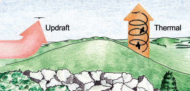
Like humans, raptors concentrate along specific routes while traveling long distances. So, just like you would find more people driving cars on highways than backroads, you’ll find more raptors along flyways. Here in the Northeast, we are part of the Atlantic flyway. Raptor flyways are normally found over level terrain. Mountains, large lakes, and oceans create obstacles that raptors cannot easily cross. Mountains do have a very important role to play, besides being simple barriers. In North America our mountain ranges run north-south. When cross winds hit these ridge an updraft is created, which raptors then use to help them soar and stay aloft. These updrafts mean raptors need to flap their wings less, conserving an enormous amount of energy for their long trip.
Image courtesy of Hawk Mountain
Updrafts are extremely helpful… when the wind actually blows. So, what do raptors do in early fall, when the sun is still high in the sky and the winds relatively calm? Physics, my friend. Even if you aren’t an avid hawk watcher, you have probably noticed vultures or hawks flying in large circles with their wings wide and high in the sky. This trick is called soaring flight and it is raptors mastering flight on thermal air currents. Thermal air currents, or thermals, are created when air heated by the sun rises from the ground into the sky. Thermals are often formed along the slopes of hills, but can also form over flat ground. As this warm air rises it cools and condenses, forming puffy, beautiful clouds. If you have a sunny, warm day with puffy clouds, it is also probably a good day for thermals and a good day for raptors to soar overhead.
Image courtesy of Hawk Mountain
Thermals typically do not form over open water; water releases heat evenly and slowly. Without any type of thermal or updraft most raptors must resort to flapping their wings, which uses an extraordinary amount of energy. If raptors decide to migrate over large bodies of water and need to flap the entire way, they are taking a huge risk: if they run out of energy, they will most likely drown. So, when raptors come across a large body of water while migrating, they typically hug the shoreline until they find a short way to cross. These short crossings often form bottlenecks where thousands of raptors pass through every year. One of the largest bottlenecks in the world happens to be in Veracruz, Mexico, where tens to hundreds of thousands of raptors migrating from central and eastern North America pass through, trying to skirt between the Gulf of Mexico and the Sierra Madre Oriental mountain range.
Identification
The identification of raptors hundreds of feet in the air, where you can often only see a silhouette against a cloud, can seem… daunting. Luckily, with a bit a practice it might be easier than you feared. Hawk watchers often utilize an identification protocol called the SPASMATIC method:
Shape
Relative sizes and proportions of wings, tail, and head
Pattern/plumage
Contrasting patterns of dark and light
Actions
How does the bird fly or what is it doing?
Size
How big is the bird in comparison to other birds?
Multiple Attributes
Use as many of the above characteristics as possible
Trust In the Concept
Believe in your ability to judge these characteristics
Shape and size are often the key characteristics you need to focus on and can be used to identify or narrow down most raptors in flight in the Northeast. Raptors (excluding owls) are broken down into 7 main shape groups: accipiters, falcons, eagles, buteos, vultures, osprey, and harriers. Each group has distinctive characteristics to help you with your identification venture.
Shape and size are often the key characteristics you need to focus on and can be used to identify or narrow down most raptors in flight in the Northeast. Raptors (excluding owls) are broken down into 7 main shape groups: accipiters, falcons, eagles, buteos, vultures, osprey, and harriers. Each group has distinctive characteristics to help you with your identification venture.
Hawk silhouettes, image from Learn.org
Accipiters (sharp-shinned hawk, cooper’s hawk, northern goshawk) typically chase and feed on songbirds in woodlands with closely spaced trees, so when in flight they have short, rounded wings and long narrow tails.
Sharp-shinned hawk, note the long tail and rounded wings. By Steve Berardi, accessed from Flicker
Buteos (red-tailed, broad-winged, red-shouldered, and rough-legged hawks) have broad-shaped wings for soaring and perching on high branches.
Red-tailed hawk, note the dark band of feathers across the belly. This can be seen in all birds, photo by USFWS Mountain-Prairie
Falcons (American kestrel, merlin, peregrine falcon) often catch prey in mid-flight in open spaces and depend on speed to capture swift prey, so when in flight you can see that they have pointed wings.
American kestrel
Harriers have broad, strong wings held in the distinctive v-shape (or dihedral shape), which allows them to fly low and slow at ground level, typically around grasslands and marshes. Northern harriers are the only harriers found in our region.
Northern harrier, photo by U.S. Fish and Wildlife Service Headquarters
Vultures (turkey and black vultures) have long and broad wings, which aids in soaring over fields and woods while searching for carrion. Turkey vultures hold their wings in the v-shape, but black vultures lack the v-shape almost entirely.
Turkey vulture, note the difference in feather color between the top and the bottom of the wings,
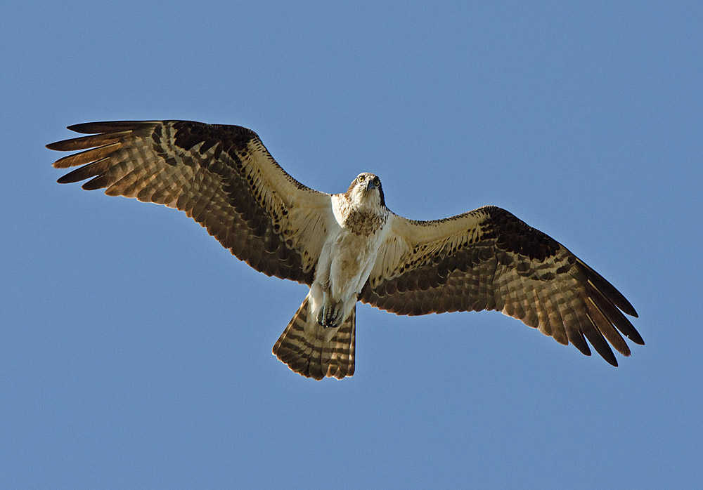
Osprey distinctively look like large gulls in both body and wing shape. Their wings help them hover over water where they dive feet first into the water to capture fish.
Osprey in flight, note the distinctive coloration of the feather, photo by U. S. Fish and Wildlife Service – Northeast Region
Eagles (bald eagle and golden eagle) have large wingspans to soar high in the air; this also aids them in capturing food in large open spaces on the ground or over water.
Golden eagle in flight, note the large, long wings, photo by Juan Lacruz
Get out and Hawk watch!
New York has multiple premier Hawk watch locations, with many of them having designated hawk counters. HawkCount gives you the ability to find hawk watch locations across North America, contacts of designated hawk counters or coordinators, and new and historical data that has been collected at these locations.
We hope you enjoy your next hawk watching adventure. Why not make your next hawk watching experience at a designated hawk watching site in a New York State Park? Here are a few to check out!
Out on the south shore of Long Island is a barrier beach called Fire Island, where the First Island Hawkwatch can be found at the east end of Robert Moses State Park. This all-volunteer watch provides coverage from September to November and has access to a hawk watch platform.
To get to the hawk watch platform, proceed south on Robert Moses Parkway and cross the bridge to Robert Moses State Park. From the water tower circle, proceed East to parking lot #5. Park here and walk east toward the lighthouse.
John Boyd Thacher State Park outside Albany
The Helderberg Escarpment Hawk Watch is found just outside Albany, NY at John Boyd Thacher State Park. At the overlook parking lot, hawk watchers can view thousands of broad-winged hawks and other migrating raptors during the park’s annual mid-September Hawkwatch Festival.
To get to overlook parking lot take I-90 to Exit 4 onto Rt 85 west. Follow Rt. 85 for about 11 miles and make a right onto Thacher Road (Rt. 157). “The Overlook” parking area is about 2 miles up the escarpment.
Braddock Bay Park outside Rochester
The great Braddock Bay area outside of Rochester, NY, is one of the top hawk watching sites in New York and is considered a migration “hot spot.” Millions of birds migrate through the area every spring as they head to breeding grounds farther north. In 1996 over 140,000 raptors were counted migrating through the area, and on April 27, 2011 they tallied 42,235 hawks: the biggest spring flight day recorded in the U.S. and Canada. The official hawk count is conducted only in the spring season between March and May. Viewers can use the hawk watch platform found in Braddock Bay Park, which is owned by State Parks and operated by the Town of Greece. The Braddock Bay Raptor Research (BBRR) has conducted the hawk watch since 1986.
To get to Braddock Bay take the Lake Ontario State Parkway until the East Manitou Road/Braddock Bay Park exit. Turn north onto East Manitou Road and turn left into Braddock Bay Park. When you come to a T in the road turn right and continue until you see the hawk watch platform on your left.
Betty and Wilbur Davis State Park
The site is adjacent to parking lot at the crest of the road through Betty & Wilbur Davis State Park. It has excellent views to the west over and across the Cherry Valley Creek Valley, and south and southeast. The view to the north is good. The hill obstructs the views northeast and due east.
Have you heard about wildfire outbreaks in California or New York on the news? Do you know how a prescribed burn and wildfire differ from one another? A prescribed burn is very different from a wildfire. Prescribed burning is a management tool that is precisely planned for safety and meeting set goals, while wildfires often occur unpredictably and without warning. State Parks utilizes prescribed burning for both public safety and conservation purposes. This past spring, at the Ganondagan State Historic Site near Rochester, prescribed burning was used for both conservation and to replicate traditions of the Seneca people.
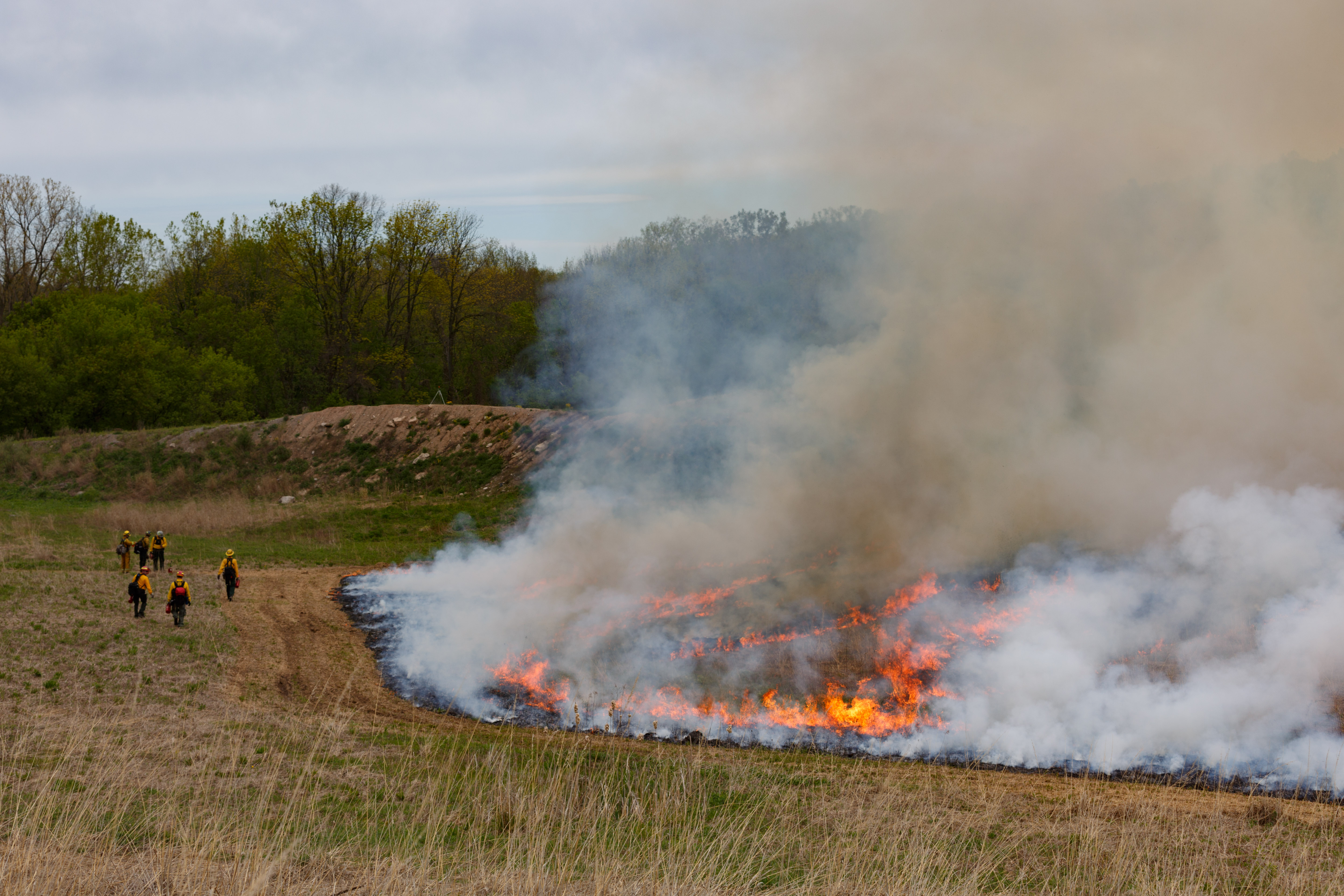
Control lines are created at the edge of the area to be burned so that the fire does not escape designated areas. These lines are approximately 12 feet wide and are kept wet and clear of fire by prescribed burn staff, photo by Joel Carlson of Northeast Forest & Fire Management LLC.
Ganondagan State Historic Site (Ganondagan) celebrates and interprets the lives and culture of the Seneca people, specifically the Seneca that lived on site between 1655-1687. The site is 570 acres, and in 2009, a 70-acre portion was set aside for grassland management. Journal entries from European visitors during the time of Seneca occupation, described the areas surrounding Ganondagan. In 1669, explorers Galineē and Dollier described vast oak openings with sparse, but lofty, oak trees and grasses taller than a man that extended for hundreds of miles in every direction.¹ These observations paint a picture of warm season grasslands, with grasses reaching heights of 8 feet or taller, sparse wildflowers and oak trees around their fringe.² Warm season grasses begin growing in June, reaching full maturity by August or September. Some of the earliest observations indicate that the Seneca people burned these grasslands annually, managing them to attract game animals and birds, and to facilitate nut collection.³
Prescribed fire at Ganondagan was lit with drip torches, photo by Joel Carlson of Northeast Forest & Fire Management LLC.
The 70 acres set aside for grassland management began its transformation in 2009, with the goal of recreating the landscape that existed for the Seneca at Ganondagan almost 400 years ago. A fully established warm season grassland can support many forms of life, and at Ganondagan it is a haven for rare grassland bird species. Grasslands are ecosystems maintained by natural disturbances like fire. Without disturbance, a grassland will gradually go through the steps of succession to become a shrubland and later a forest.
Before the prescribed burn at Ganondagan in May 2017, the grasslands had begun to build up a thick thatch layer, decreasing both the amount of sunlight reaching its sun-loving plants and the amount of bare ground between plants (which grassland birds and mammals like for habitat).
A successful prescribed burn is designed to keep the fire within control lines and the smoke up and away from people and homes, photo by Joel Carlson of Northeast Forest & Fire Management LLC.
Time of year can play an important role in how an ecosystem reacts to a burn. At Ganondagan, a spring burn was chosen to cut off early growth of invasive species and to promote the growth of the warm season grasses like big bluestem and Indian grass. Future prescribed burning done on the site may happen in different seasons depending on the desired outcome. For example, a prescribed burn taking place in this warm season grassland in the fall would promote the growth of forbs (broad leaved plants), such as wildflowers. Regardless of the timing, a properly done prescribed burn will not completely remove grasses or forbs, but can help achieve the best plant composition for grassland birds.
Prescribed burning was the perfect way to manage the grasslands at Ganondagan: it created a disturbance to maintain the ecosystem, returned carbon and nitrogen to the soil in the form of ash, and opened the grassland to more sunlight. This burn also provides a unique opportunity for educators to interpret this management tool, once used by the Seneca at Ganondagan to maintain the grasslands in the 17th Century, and now updated for the 21st century!
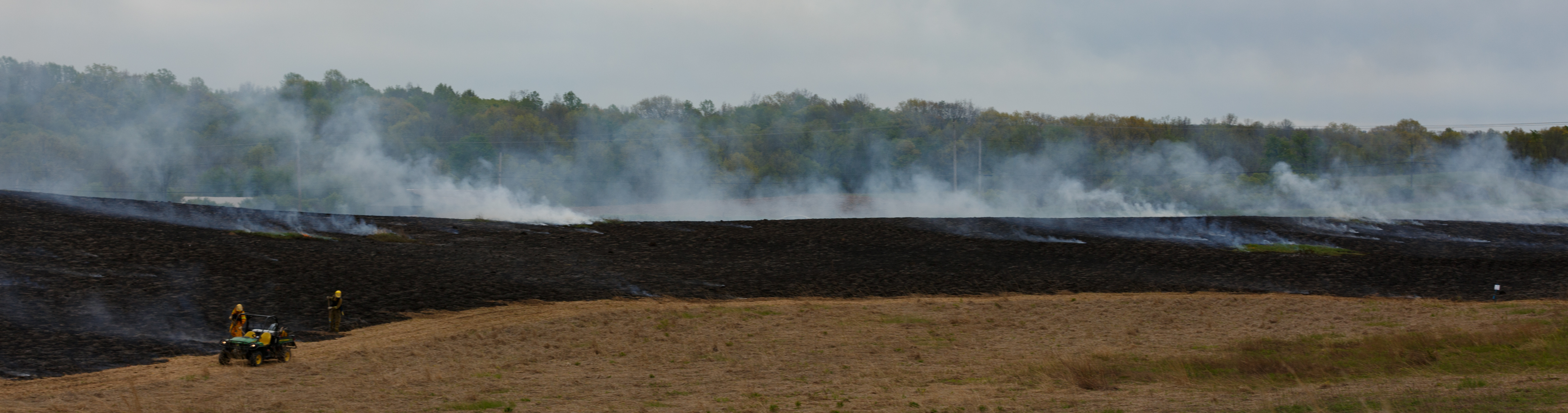
The ‘mop up’ of a prescribed burn ensures that all of the fire is completely out and, as in the case of the Ganondagan Prescribed Burn, can take longer than the burn itself, photo by Joel Carlson of Northeast Forest & Fire Management LLC.
This valuable management tool will continue to be used at the Ganondagan State Historic Site and are exploring future opportunities.
Post by Whitney Carleton-DeGeorge and Michael Galban , State Parks
Featured image: Joel Carlson of Northeast Forest & Fire Management LLC.
1 Galinée, René de Bréhant de. (env. 1670) 1903. “Le Voyage De MM. Dollier et Galinée.” In Exploration of the Great Lakes 1669-1670 by Dollier de Casson and de Bréhant de Galinée, ed. James H. Coyne. Toronto: Ontario Historical Society Papers and Records.
² Parker, Arthur – New York State Archeologist – “The League of the Five Nations – a Story of the Aboriginal Empire State” published in Livingston County Historical Society 34th Annual Meeting, Geneseo, NY, 1910.
³Donck, Adriaen van der, 1620-1655. (Beschryvinge van Nieuvv-Nederlant. English) A description of New Netherland / Adriaen van der Donck; edited by Charles T. Gehring and William A Starna; translated by Diederik Willem Goedhuys; foreword by Russell Shorto.