At the western edge of Hamlin Beach State Park, beyond a row of trees, is Yanty Marsh Trail. The trail loops through a deciduous (broadleaf) forest along the lake, pausing to overlook a large marsh and winding beneath the canopy of a white pine grove. In the fall, beech leaves paint the sky in their wistful yellow hues as the birdsongs of spring and summer slowly grow fainter. Chipmunks gather their last nuts for the winter and the mystical great blue heron observes overhead. The white pines stand stoic among the falling leaves. As chilly mornings and early sunsets lure the marsh into slumber, the world stalls. The 65 acres of Yanty Marsh are released from the sweltering days of summer, the balance of the seasons returning.
The beauty of Yanty Marsh.
A hundred years ago, this scene looked different. With each freeze and thaw of the marsh, the stories of its past fade alongside time. An area once deforested and at risk of disappearing, the marsh and surrounding land have transformed over the past hundred years into the deciduous trail and marsh so many enjoy today.
Many buildings and features built for New York state parks during the 1930s mimicked the natural environment. In the period after World War II, this rustic style started sharing space with more modern designs.
One of the busiest construction periods of the New York State Parks system was during the 1950s and 1960s, when park planners were expecting to welcome record numbers of visitors. You can learn more about that history in our Blazing a Trail timeline project. But, for a deeper dive into the architecture leading up to that era, keep reading…
Across New York State, visitors took time during the summer to cherish the lands they love by attending events honoring the system’s Centennial. Our parks and historic sites held numerous activities celebrating the 100-year anniversary , which ranged from community commemorations and canalside concerts to kayak parties and other festivities. This sampling demonstrates the breadth of unique experiences available to visitors, with more to come as we approach the final months of 2024!
If you were told there could be volcanoes along the shore of Lake Erie in winter, would you believe it? While it may be hard to imagine, Lake Erie does in fact produce volcanoes and Evangola State Park can be one of the best places to see them!
Unlike traditional volcanoes, the ones found at Evangola State Park are not made of rock and magma, but rather water and ice. Ice volcanoes are a temporary outcome of a partially frozen lake. When ice begins to form on the water’s surface, powerful winds push large waves towards the shore. As they do, the water is sandwiched between the shore and the ice, creating a buildup of pressure.
A gap in shelf ice allows for potential formation of an ice volcano.
Eventually with nowhere else to go, this pressure causes the water to burst through cracks in the ice. The resulting spray from this burst, freezes on the ice surface, accumulating in the shape of a cone with an open, unfrozen center. With each successive wave, plumes of water erupt from the newly formed ice volcano, building this winter wonder to potential heights of 20-plus feet! Occasionally the ice may build up in the shape of a cone, but without an open center. These rolling hills of ice become so called ice-dunes.
While Lake Erie is one of the best locations to see ice volcanoes, Lakes Ontario, Michigan, and Superior can also produce these icy cones when conditions are right. For example, such volcanoes have also recently formed during the cold snap at Hamlin Beach State Park in Monroe County and Fair Haven Beach State Park in Cayuga County.
Ice Volcano at Hamlin Beach State Park in February 2022. (Photo Credit – Friends of Hamlin Beach State Park/Denise Bianrosa Duffy)
Further from home but to the excitement of many, in 2021 a 45-foot tall ice volcano formed in southeastern Kazakhstan as water from a hot spring gushed through a thick layer of ice, creating a massive volcano for all to enjoy.
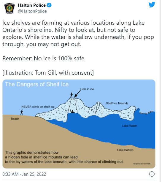
But also, to be clear, the shelf ice on a lake where these structures form can be extremely unsafe and people are strongly advised against venturing out on it to get closer to ice volcanoes.
Confine sightseeing to the shoreline or stick with a guided tour by a trained Parks naturalist. One such hike is scheduled for Feb. 8 at Evangola State Park. Check with the park to learn if the volcanoes have formed.
As a recent warning from the police department in Halton, Ontario, describes, if someone falls through shelf ice or down the opening of an ice volcano into the lake water below, it can be nearly impossible to get out even if aid is nearby. Cold lake water can quickly induce hypothermia, which can lead to death.
This graphic below illustrates the danger:
A shoreline guided tour past ice volcanoes at Evangola State Park. Remember, DO NOT venture out on shelf ice or approach an ice volcano. It is EXTREMELY DANGEROUS with the potential for falling into the lake water below with little chance of getting out.
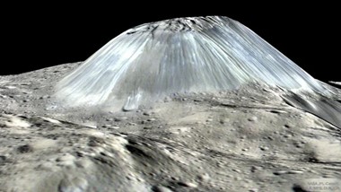
Leaving earthly risk behind for a moment, scientists have even been able to detect ice volcanoes from several planets and moons deep in space. Typically called cryovolcanoes, these are defined as volcanoes that erupt with ice, water, or other materials such as methane and ammonia. In 2010, NASA’s Cassini spacecraft found possible ice volcanoes on Saturn’s moon Titan and in 2016 images from the Dawn space probe revealed dozens of ancient ice volcanoes on the dwarf planet Ceres
Ahuna Mons, an ice volcano on the dwarf planet Ceres, as seen by NASA’s Dawn spacecraft. (Photo Credit – NASA, JPL-Caltech, UCLA, MPS, DLR and IDA
Back on earth, favorable conditions for ice volcano formation here in New York haven’t been consistent in recent years. Warmer winters have resulted in less ice on all the Great Lakes. In 2021, the National Oceanic and Atmospheric Administration reported that only 2.4 percent of the Great Lakes surface was covered by ice in late January, the smallest amount in nearly 50 years. It was also noted that it was ninth-warmest January on record. While strong waves are needed to form ice volcanoes, strong waves with warmer temperatures will result in their destruction or prevent them from forming at all.
Despite our changing climate, ice volcanoes can still be a common occurrence during the winter months. The biggest change is in their longevity. For example, in the past several years, ice volcanoes at Evangola State Park have only lasted a few weeks or even just a few days after forming, as sudden warm spells take hold and break them apart.
For your best chance to experience ice volcanoes, be sure to keep a close watch on your local weather forecast and head towards the lake shore after a push of cold artic air passes through. To add to the adventure of enjoying these frozen phenomena, our team of environmental educators offer guided hikes all winter long, sharing what makes our Great Lakes environment so unique.
An ice volcano “erupts” (on left) at Fair Haven Beach State Park on Lake Ontario. Photo credit – Caroline Lamie, Office Manager/Senior Researcher/Tour & Event Coordinator, Fort Ontario State Historic Site
Cover shot – Ice Volcanoes in 2021 at Evangola State Park. All photos NYS Parks unless otherwise noted.
Post by Matt Nusstein, Environmental Educator, Niagara Region NYS Parks
Along the shores of Lake Erie, Evangola State Park becomes a winter sports mecca as the lake’s famous lake-effect snowstorms blanket the park! Lake-effect snow occurs when cold, Canadian air moves across Lake Erie evaporating its open waters and causing intense, local snow bands which can drop one to two inches of snow per hour.…
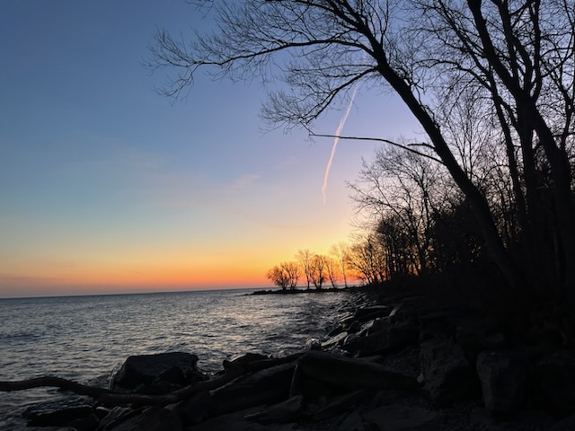
Getting cabin fever? Well, bundle up and take a trip to a beach-front state park! Lake Ontario, Lake Erie, Lake Champlain, Long Island parks or the many parks on small lakes: Glimmerglass, Green Lakes, Long Point-Chatauqua Lake, Allegany, or many others. This is the time to explore the many interesting patterns and colors of wintertime…
Situated along western Lake Ontario’s shore and inland, this region includes Letchworth State Park, also widely known as the “Grand Canyon of the East,” as well as a 90-mile trail on a former canal towpath, an ecologically-important lake marsh, and some spectacular lakeshore sunsets.
Covering Genesee, Orleans, Monroe, Livingston and Wyoming counties, this region includes seven state parks and two boat launches, one on Lake Ontario and the other on Conesus Lake.
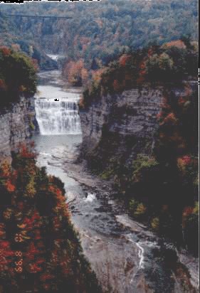
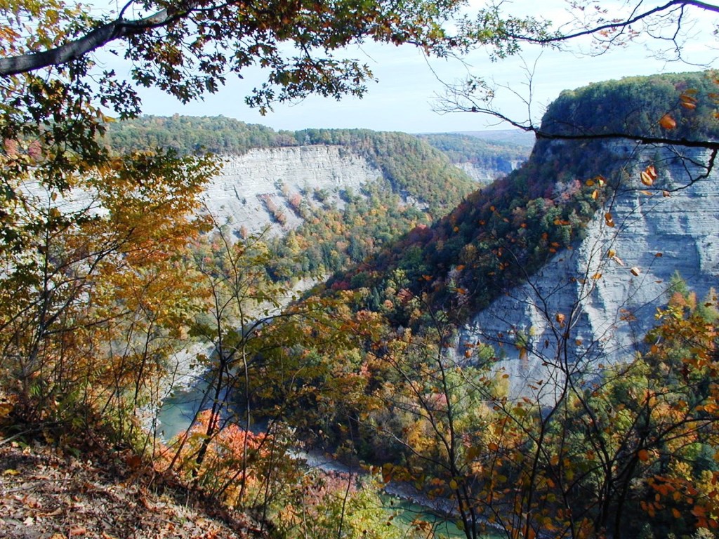
Letchworth State Park is the region’s 14,350-acre masterpiece, featuring a wild 17-mile gorge carved by the Genesee River tumbling over waterfalls and meandering through the heart of the park, providing spectacular views at every turn.
Maps for hiking trails and a variety of other useful information on State Parks, including those in the Genesee Regoin and elsewhere, are now available on the NYS Parks Explorer app. The free app, which is available for use on Android and iOS devices, is easy to download, user friendly and allows patrons to have park information readily available.
Trail maps are also available on each individual park website page at parks.ny.gov and at the main office of each park. Be sure to download maps ahead of time or carry a paper copy as a back up
As with all hikes, there are a few things to remember beyond carrying a mobile phone. Check the weather forecast before you go, and dress appropriately. Wear sturdy, yet comfortable shoes or boots, bring water and snacks, and perhaps carry a camera to capture what you see. Be aware of your surroundings and mindful of hikes on steep terrain or those that go near cliff tops. Having a small first-aid kit available in case of an emergency is never a bad idea.
For longer trips, hiking poles are also useful and can transfer some of the stress of hiking from your knees and legs to your arms and back.
Hikers should plan their route in advance, know how long a trail is and how long it ought to take to finish. Since daylight is not an unlimited resource, even in spring as the days grow longer, tossing a flashlight or headlamp into your backpack is a good form of insurance, should you unexpectedly find yourself on the trail as dusk approaches.
Parks facilities are carry-in, carry-out, so don’t leave trash behind. Follow Leave No Trace principles to keep trails clean for everyone.
Additionally, as incidents of tick-borne diseases surge in the state, it is always important to check yourself for ticks after being outside, even if it is only time spent in your own backyard. Spring can be a risky time as the tick nymphs are emerging. Nymphs are tiny and difficult to spot.
Lastly, as the COVID-19 pandemic continues, remember to practice safe social distancing, particularly in parking lots and at trailheads, and use face coverings when a distance of six feet cannot be maintained, even if you have been vaccinated. To learn more about important COVID safety guidelines, CLICK HERE.
Livingston County/Wyoming County
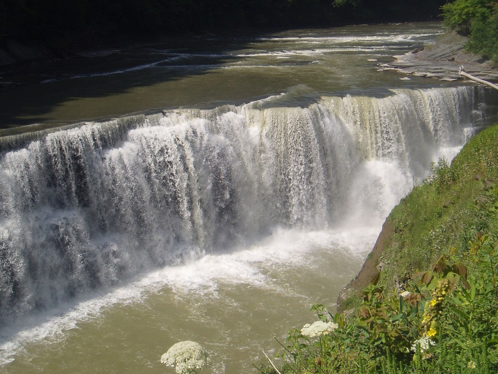
Letchworth State Park, 1 Letchworth State Park, Castile (585) 493-3600: Carved by the immense forces of ice and water during the last Ice Age, this sprawling park resides in both Livingston and Wyoming counties. Within Wyoming County lies much of the original 1,000 acres that was a gift from William Pryor Letchworth in 1907 that can be seen from the seven-mile Gorge Trail. This trail travels past his beloved Upper, Middle and Lower Falls.
(Clockwise from bottom left) Middle Falls, Gorge Trail view from Inspiration Point, Gorge Trail View of Great Bend Gorge, Lower Falls, Upper Falls.
The Gorge Trail has many spectacular views of Sehgahunda (The Vale of Three Falls). The Portage Canyon represents a recent detour by the Genesee River since the last Ice Age some 10,000 years ago from its ancient pre-glacial valley south of Portageville. The Gorge trail also passes a 100,000 year-old interglacial valley known as Lee’s Landing. At the Great Bend Gorge, the trail overlooks a section of gorge that is about 550 feet deep and a quarter-mile wide.
At the north end of the park, find the five-mile Highbanks Trail (listed as Trail #20 on the park map), which offers its own breathtaking views of the gorge. Highlights include great views of the Mt. Morris Dan, the largest concrete dam east of the Mississippi River which was built in the early 1950s to protect the city of Rochester from flooding. This trail also affords views of the unique ridge feature known as the Hogsback, and of numerous stream crossings. This trail is a one-way out and back.
This section of the park includes the Highbanks Tent and Trailer Campground, the C-Cabin loop, and the G.W. Harvey Swimming Pool.
The Hogsback from the Gorge Trail at the north end of the park.
Mt Morris Dam (Photo Credit – Livingston County Historical Society)
Genesee Valley Greenway State Park, 1 Letchworth State Park, Castile, (585) 493-3614: This unique linear park is a 90-mile multi-use trail with one end in Monroe County and the other in Cattaraugus County. The route mainly follows the old towpath of the Genesee Valley Canal, which was in operation from 1840 until the late 1870s, and remnants of the old canal can still be seen. Come to stroll, hike or bike any part of of this trail.
The Greenway Trail affords beautiful scenic views and historic sights, including a well preserved canal lock in Scottsville (Monroe County), crossing the Genesee River along a footbridge in Mount Morris (Livingston County), observing a beautiful oxbow feature in Portageville (Wyoming County), secluded woods walking in Belfast (Allegany County), and gorgeous mountain views in Hinsdale (Cattaraugus County). Be sure to check out the communities found long the route of the Greenway for some great local fare.
The Genesee Valley Greenway trail goes past remnants of former Genesee Valley Canal Lock No. 2 in Scottville.
(Clockwise from bottom left) The trail passes an oxbow pond in Portageville, crosses the Genesee River in Mount Morris, and enters forest in Belfast.
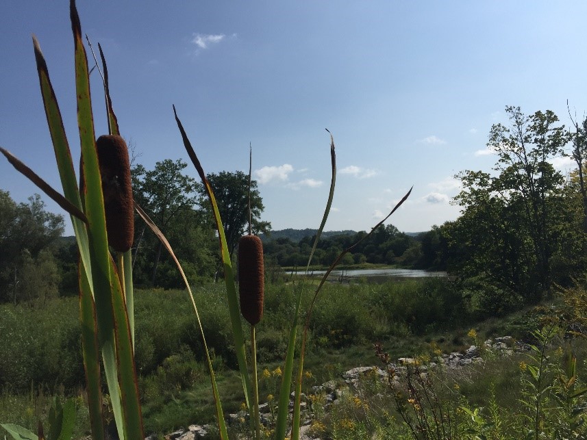
Hamlin Beach State Park, 1 Hamlin Beach Blvd. West, Hamlin (585) 964-2462: Located on Lake Ontario with a sandy swimming beach, this park also has several miles of hiking trails.
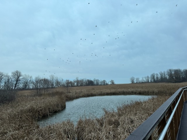
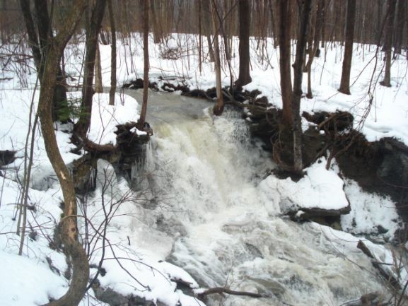
One of the most unique is the Yanty Marsh Trail, which features a boardwalk within a freshwater marsh rich in wildlife and plants, including cattails, pickerelweed, willow and milkweeds; some 200 species of birds, and frogs, snapping turtles, snakes, muskrats, beavers, mink, fox, racoon and deer.
Yanty Marsh Trail
The flat, accessible trail of one mile is also linked to the park’s history during the Great Depression when President Franklin D. Roosevelt created the Civilian Conservation Corps to put unemployed men back to work on projects that included creation of Hamlin Beach State Park. Relics of the CCC still are visible throughout the park. This includes and old farm pound once used by the CCC men for ice skating located just off the trail. When a 1998 storm severely damaged the marsh, opening it up to the damaging effects of erosion, the U.S. Army Corps of Engineers stepped in to assure the marsh wasn’t washed away forever. With control measures implemented, the marsh now fulfils its ecological role, to filtering toxins from run off into the lake, storing oxygen from our atmosphere, as wells as providing a home to many species of plants and animals.
The Devil’s Nose Trail along the lakeshore bluff offers beautiful views and a colorful history. Much folklore has been spun about Devil’s Nose and the suspected shipwrecks caused by the unique land feature. The name “Devil’s Nose” dates to 1802 but the origin of the name remains a mystery. At one time the nose was 150 feet tall and reached northward into the lake a quarter mile. A red lantern once marked the tip of the nose as a warning to passing vessels. Today the nose has all but collapsed but the shallow reef and large costal bluff remains. Although the reports of shipwrecks on the nose remain unproven, it is known that during the age of prohibition smugglers used the Nose’s coves and passages to smuggle goods and hide from authorities. After being closed for years due to overuse and erosion, the trail was refurbished and reopened in 2018. Patrons can access the trail through Area 5. A wonderful spot to watch summer sunsets, but please stay on the trail, as the banks are steep and fragile.
Darien Lakes State Park, 10475 Harlow Road, Darien Center (585) 547-9242: The hilly woodlands of this park contain nearly nine miles of hiking trails, as well as a sandy swimming beach to sunbathe or swim once a hike is done.
The two-mile Conservation Trail has a new lean-to ready for use, while as the southern end of the trail there is a picturesque waterfall. The trail goes by woodlands, fields and streams, offering views of a variety of wildflowers, trees, birds, insects and other interesting critters.