From placid lakes and intimate mountain streams to broad rivers and sea-foamed saltwater coast, the state park system offers limitless fishing possibilities and the enticing prospect of “tight lines.” Striped bass, bluefish, salmon, trout, panfish and freshwater bass are but a few of the many popular fish species that can be fished for at state parks, with angling set amidst the backdrop of some of the state’s most compelling and dramatic natural scenery.
For a reel-y good time: fishing is a whole different way to connect with the outdoors. Photo by Susan Lananger, Allegany State Park.
While some anglers may prefer the fall striped bass bonanza at Montauk Point, with its festive atmosphere and challenging rock-strewn shoreline, others may find flyfishing for brook and brown trout on the remote hemlock-lined streams of Allegany more to their liking. State parks additionally offer numerous options for recreational boat fishing. Launches for motorized boats are located strategically throughout the state on prime angling waters, along with smaller docks and launches providing lake and river access for canoes, kayaks and the like.
State parks offer anglers premier opportunities on two great lakes, the Hudson, St. Lawrence, Niagara and other smaller rivers, numerous streams and brooks, countless lakes of varying size and setting, and the saltwater shores of Long Island Sound and Atlantic Ocean. If there’s a fish to be angled for in New York State, be it fresh or saltwater, chances are good that it can be found in a state park.
Through I Fish NY, the New York State Department of Environmental Conservation helps New Yorkers understand the basics of fishing legally and offers opportunities to try the activity. Our parks often hold fishing programs as well. Read on for our guide to angling at state parks!
There’s more to nature in New York City than rats and pigeons! From wriggly eels to soaring falcons, there are plenty of species that thrive in and around the concrete jungle. Prehistoric creatures roam our shorelines. Ancient trees line our streets. Read on to learn more about some of the species that make up the hidden nature of NYC.
Before the invention of electric refrigeration, how did food and perishables keep cold, especially during the warm summer months? The answer is ice. Large blocks of ice cut from a river or lake during the winter would keep food items cool all summer. But how did the ice move from there into the home?
That feat was the work of an expansive ice harvesting industry, which was active throughout much of the northeast coast of the country (as well as inland, in northern states) between the 1830s and 1920s, and which was dominated for several decades by production on the Hudson River and nearby lakes.
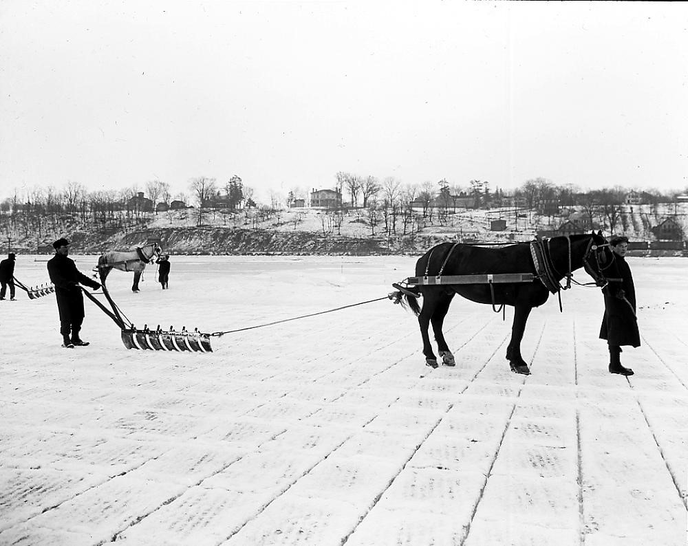
Workers guide a horse pulling an ice-cutting rig on the Hudson River, circa 1912. (Photo Credit – New York State Archives # A3045- 78_830)
Although Staatsburg in Dutchess County is a quiet hamlet today, it was once a bustling hub of the ice harvesting industry. Ice was a very valuable natural resource, which required an impressive amount of infrastructure and investment to cut and transport to customers. The labor came from a small army of men and horses.
In the 19th century, as cities grew in size and population, the demand for ice to preserve food and cool people in warm weather grew tremendously, as urban populations did not have immediate access to frozen ponds and rivers. Hamlets and towns along the Hudson developed a robust trade to supply the demand downriver in New York City, and export ice to other, farther-flung locations.
Another significant consumer of ice was the brewing industry, which used ice in regulating the temperature of fermentation so that beer could be made year-round rather than in a limited number of months. As the meat-packing industry grew, it too consumed large quantities of harvested ice.
Records by two different ice companies reflect the harvests from Staatsburg and Rockland Lake in this April 1866 report in the Rockland County Journal. (Photo Credit – Peter Stott, “The Knickerbocker Ice Company and Inclined Railway at Rockland Lake,” Journal of the Society of Industrial Archeology, Vol. 5, No. 1 (1979), page 9)
Some households, like the affluent Gilded Age owners of what today is the Staatsburgh State Historic Site, had the luxury of filling their ice house with ice from a body of water adjacent to their property, but others did not have the same resources and had to purchase ice.
This country estate and 79-room mansion of the very wealthy Mills family frequently hosted parties of houseguests for elegant weekends, and boasted all of the era’s cutting-edge technology and luxurious amenities available, including electricity, gravity-fed plumbing and ice-cooled culinary delicacies.
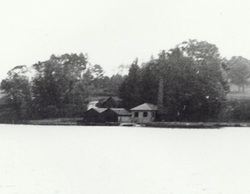
With a large staff of estate and farm workers, Staatsburgh had the labor needed to cut and store a year-round supply of ice from the Hudson for its own icehouse each winter. A period photograph of the estate buildings at the river’s edge suggests the location of the now missing icehouse: a peaked roof appears behind the double-roofed boathouse complex on the water, and to the right of the powerhouse, which generated electricity for the estate. (While the powerhouse still stands along the riverbank, its chimney, seen in this photograph, no longer exists).
This photo likely depicts Staatsburgh’s now-removed icehouse, its peaked roof visible behind the double-roofs of the boat house, and to the left of the powerhouse and its chimney. This location would have placed the icehouse on the incline of a steep slope toward the river, which was needed for drainage of melt water from the icehouse.(Photo Credit – NYS Parks)
Judging from this photo, the estate’s icehouse sat several yards away from the riverbank, on a fairly steep incline, which would have provided the excellent drainage needed as ice melt occurred during the year. Icehouses uniformly had a system of drainage at their base, along with insulated walls (often double walls) and interiors carefully designed to reduce humidity (which promotes melt) and provide maximum insulation. A well-designed icehouse, packed expertly, could provide ice a full year until the next ice harvest.
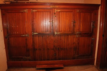
As seen below, the ice box inside the mansion at Staatsburgh is quite large, meriting an entire room in the basement as part of the house devoted to food preparation. It bears a brass label reading, ‘The Lorillard 1168 Broadway,’ which identifies its maker. Lorillard was a company that manufactured refrigeration units from 1877 until approximately 1920. The company produced some of the most expensive iceboxes on the market which could be found in the homes of wealthy families like the Vanderbilts, Carnegies and the Mills.
The Lorillard brand icebox at the Staatsburgh mansion was top of the line during the Gilded Age. (Photo Credit – NYS Parks)
Producing and storing ice had been practiced since ancient times in Asia and other parts of the world, by controlling evaporation, but in America, the impetus for a fast-growing ice harvesting industry, drawing on naturally-produced ice in cold weather, is credited to the “Ice King of Boston,” a man named Frederick Tudorwho between 1805 and 1836, developed technical advances that made ice harvesting and storage profitable, creating a mass market for ice. Through tireless experimentation, Tudor reduced loss from ice melt in storage from 66 to 8 percent, and created markets for shipping his product in southern states and the Caribbean.
One of Tudor’s employees, Nathaniel Wyeth, patented the horse-drawn ice cutter which was the first tool to cut even-sided, regular blocks of ice. Before his invention, ice was hacked out in irregular chunks, which led to much loss from melt and inefficient shipping and storage. Wyeth’s innovation made possible a viable ice industry.
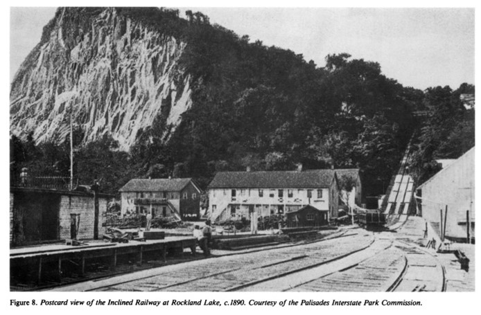
Another premier site for ice production in New York State was Rockland Lake approximately 30 miles north of New York City on the Hudson River’s western shore in Rockland County. Now the location of Rockland Lake State Park, beginning in 1831 ice from the frozen 256-acre lake was transported with the aid of gravity about 150 feet down to the river for shipping to the city. A steam-driven inclined railway for its transport was completed by 1860. Improved machinery to replace human and horse power continued to be developed throughout the age of ice harvesting.
A steam-powered inclined railway brought ice from Rockland Lake for shipment to New York City markets. (Photo Credit – NYS Parks)
Rockland Lake, a 256-acre spring-fed lake at the foot of Hook Mountain, is today one of the most popular state parks in the Hudson Valley. Its two golf courses, pool, tennis courts, hiking trails, and ball fields attract legions of people in the summer months, who come to fish, picnic and play in this park…
Despite rapid expansion, the Hudson Valley ice harvesting trade was consistently outrun by increasing demand for ice, as populations grew, cities expanded, and industries to feed people increased. Complicating things further, ice harvesting was dependent on the weather, and, as a reporter on the trade in 1880 described, “…in not more than two out of three years is the crop a fair one.” An ill-timed week of warmer temperatures or a rain storm could dramatically reduce the ice yield.
To meet consumer demand and surmount the vagaries of weather, inventors were keenly focused on developing efficient artificial ice production and refrigeration. In its heydays — between 1840-1920, however, the Hudson Valley ice trade employed up to 20,000 men (and a thousand horses) during the intense weeks of cutting and storing the cold-dependent commodity. Ancillary industries sprung up along the river: barges and ships designed specifically for ice transport, enormous icehouses, ice tool businesses, stables, boarding houses for workers and fields to grow the insulating hay and timber for dunnage (material used to keep cargo in position in a ship’s hold).
This illustration shows the design of barges made to transport ice down the Hudson River. By 1880, author Henry hall reported that “On the Hudson, a large fleet of barges, built especially for the trade, are employed. There are about 100 of them at present…They carry from 400 to 1,100 tons of ice… A small windmill revolves around the top of the roof [of the cargo house] and drives a pump for clearing the hold of water from the melting ice.” (Photo Credit – Henry Hall, The Ice Industry of the United States: With a Brief Sketch of its History and Estimates of Production in the Different States. SOURCE: U.S. Dept. of the Interior, Census Division, Tenth Census, 1880., vol.22, Washington, Government Printing Office, 1888)
From approximately 1840 to 1920, ice was harvested from the Hudson River, particularly north of Poughkeepsie. The ice near New York City was not used because, as an estuary, it contained too much salt, which would result in ice that resisted freezing and melted more quickly than the ice from freshwater further north.
Ice harvesting began in January and on average continued for about six to eight weeks or until the icehouses were filled. The harvesting season was very limited and ice had to be at least six inches thick to be cut, since melting would have occurred in storage and transit; conversely, blocks too large were unmanageable for workers to transport. Men accompanied by horses, and later aided by steam-driven mechanical devices, often worked ten hours a day and seven days a week harvesting and storing ice. In January 1895, the Poughkeepsie Eagle-News reported that many pack peddlers abandoned their routes to work at ice harvesting. Residents of the mid-Hudson Valley who made bricks or farmed in the warmer months, found good employment in the winter harvesting of ice, while other workers handled the shipping of stored ice to markets in the fall, summer and spring.
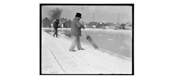
The process of harvesting ice from the river involved clearing snow or dirt from the surface with horse drawn plows, and sometimes planing smooth the surface. The area was measured and then scored into a grid by a horse-drawn “marker,” resembling a plow. Another tool (Wyeth’s ice plow, or a derivative of his invention) then cut blocks free. The long lengths of ice were then floated toward the shore in an open water channel. Once they neared the ice house on shore, a final cut was made with a 4 or 5 foot-long handheld saw. The ice was moved into the ice house by a horse-drawn or, later, steam-powered elevator or conveyor belt. Workers used a pole to hook the floating blocks of ice and position them on the elevator. Inside the ice house, the blocks were insulated by sawdust and hay between layers to prevent them from melting and fusing. When the demand for ice began from March onward, barges carrying anywhere from 400 to 1000 tons of ice would ship the ice down the river to sell.
A worker uses a hand saw to cut ice blocks , circa 1900. (Photo Credit – U.S. Library of Congress)
In its heyday, Staatsburg had at least ten private commercial icehouses. Many companies operated in New York City, but had an ice house in Staatsburg to store ice from that section of the river including the American Ice Company, the New York Ice Company, the Mutual Benefit Company and the Knickerbocker Ice Company. According to an article in the New York Daily Herald published February 13, 1874, the Mutual Benefit Company had an ice house at Staatsburg that held 15,000 tons of ice. The company employed 75 men, 10 boys, fivehorses, and a steam engine to fill the ice house. The largest ice harvesting company was the Knickerbocker Ice Company, which was based in New York, but had ice houses all along the Hudson. Their ice house in Staatsburg held 25,000 tons of ice and they employed over 10,000 men in the region. In 1896 they had a capacity for 1.8 million tons of ice, which was approximately 50 percent of the entire industry in New York.
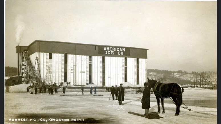
The icehouse for the American Ice Co. in Kingston. (Photo Credit – Kingston Daily Freeman – February 19, 1909)
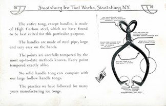
In addition to commercial ice harvesting in Staatsburg, one of the most successful companies in the village produced tools for the trade. After J.H Bodenstein (1823-1875) emigrated from Germany, he settled in Staatsburg and started a blacksmith shop that made tools used for ice harvesting. The business officially became the Staatsburg Ice Tool Works in 1868 and the family business continued for four generations. The family held approximately twenty patents for various ice harvesting and other tools including this one for an ice cutting tool. A catalogue of their ice tools is found here.
The works sold their products both across the United States and abroad. The business lasted for more than a century before closing in 1984 when all of the buildings and equipment were sold by the fourth generation of the Bodenstein family.
A catalogue for the Staatsburg Ice Tool Works illustrates a pair of ice tongs. (Photo Credit – J. G. Bodenstein & Co., Catalogue No. 102, accessed from Archives.org
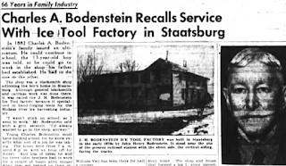
A worker recalls his service at the Staatsburg Ice Tool Wors in the March 14, 1949 edition of the Poughkeepsie Journal.
Once ice was cut from the river and stored in the ice house, its final destination was the ice box inside individual homes and restaurants, or businesses such as breweries and food transport. After the Civil War, ice boxes became affordable for the working class, which contributed to the growth of the ice harvesting industry.
The end of it all came into view when the first electric refrigerator for home use was invented in 1913, but it was not until the late 1920s and several models later that the use of an electric refrigerator in the home became more common and affordable. This rang the death knell for the ice harvesting industry. Artificial ice was now able to keep food cold all year long and ice harvesting became a thing of the past by the 1930s.
Today the Hudson River rarely freezes long enough to produce ice of any useable thickness so ice harvesting really is a thing of the past in the Hudson Valley. For a further look into ice harvesting in the Gilded Age and Staatsburgh’s high-end ice box, enjoy the following video from Staatsburgh interpreter, Frank Pidala.
Cover Photo – Workers use ice pike poles to guide blocks of ice through a chip canal to an ice house on the Hudson, circa 1912 (Photo Credit – Photo: New York State Archives, #A3045-78_834)
Post by Maria Reynolds, Historic Site Assistant/Curator, Staatsburgh State Historic Site
Iona Island, located along an elbow of the Hudson River in Bear Mountain State Park, is technically an archipelago of three islands connected by marshlands. Iona has had many owners in its storied history, prior to being bought by New York State in the 1960s. The Island was host to Native American tribes for thousands of years, who took advantage of the plentiful shellfish along its shores. In the last few hundred years, it has been the site of an unsuccessful vineyard, a hotel and weekend destination for NYC residents, a U.S. Navy arsenal, and a partially built park recreation area. The eastern side of the island past the railroad tracks has been closed to the public since the 1980s, but a small portion of the island consisting of the five remaining Navy buildings is used for storage for the Palisades Interstate Park system. The rest of the island has returned to a more natural state of woods, meadows, and rocky outcroppings and serves as a sanctuary for wintering bald eagles. The island achieved National Natural Landmark status in 1974, and was designated a NYS Bird Conservation Area and Audubon Important Bird Area shortly thereafter.
A key natural feature at Iona is the extensive marshlands, 153 acres in all, flanking its western side. Part of the Hudson River National Estuarine Research Reserve (HRNERR), this brackish tidal marsh (marshes with water that has different concentrations of salt depending on the tides) teams with life including fish, waterfowl, waterbirds, plants, and crustaceans. In recent times, the rich biodiversity of the marsh, including a number of state rare species, has been threatened by Phragmites australis, or as it is more widely known, common reed.
Common reed (Phragmites australis) is a plant that was likely brought to the US from Europe and Asia in the 1800s through ship ballast or the water taken in by ships to allow them to balance on long voyages. Commonly referred to as just Phragmites, this non-native plant is invasive in the U.S., displacing and crowding out native plant species, such as cattails, rushes, asters, and many others. In turn, the presence of this species has undermined the complex web of marsh dependent organisms.
The non-native Phragmites is identifiable by its tall stature, dark blue-green leaves, and tendency to form dense stands, with little to no possibility for native species to grow in the areas that they occupy. A native species of phragmites (Phragmites americanus) occurs in NY as well, but this smaller plant with reddish stems grows with less density so it does not crowd out other flora.
Iona Island Marsh in 2008 before treatment. Phragmites dominate the background.
The phragmites problem at Iona Marsh began in the early 1960s, when the first small colony appeared near a pipe draining into the marsh. Over the next 40 years, phragmites steadily expanded until it covered nearly 80 percent of the marsh area. Researchers tracking these changes noted a concurrent decline in marsh specialist birds and specialized brackish marsh plants, including state rarities. In an effort to reverse these trends, the Palisades Interstate Park Commission, while partnering with Hudson River National Estuarine Research Reserve and the Highlands Environmental Research Institute, started a New York State Department of Environmental Conservation (NYSDEC) funded management program in 2008 focused on a 10-acre test area. The goal was to reduce the invasive phragmites, and make room for native plants to once again occupy the area. If the program was successful in this small area (1/15th of the marsh), it could be expanded to additional marshlands.
A multi-faceted control and monitoring program has been developed and implemented and the results have been dramatic. More than 90% of the phragmites was eliminated within one year and nearly 97% by the third year. Researchers saw the return of huge meadows of annual native marsh plants, including some state-threatened species, followed by perennial cattail stands. Marsh specialist birds such as Virginia rail, least bittern (State-threatened), and marsh wren followed soon thereafter. Based on this success, the project was expanded to an adjacent 32-acre area of the marsh known as Ring Meadow. Both areas now have less than five percent Phragmites cover, an overall success on the journey to reestablish native vegetation.
Map of the Iona Island Marsh Treatment Areas
While complete eradication of the Phragmites may be impossible to achieve, success can be maintained through continued monitoring and spot treating remaining and new patches. Bird and vegetation surveys are conducted annually, as are measurements of sediment build-up on the marsh surface, as it relates to sea level rise. The goal remains to restore the native plant communities in the marsh to promote biodiversity. A healthy, native marsh community will lead to increased productivity and habitats for fish, birds, and mammals – many of them specially adapted to the brackish conditions at Iona. With continued management, the long-term outlook is positive for this Hudson River jewel, one of only four large brackish marshes on the Hudson.
Ring Meadow in 2016. Cattail and blooming Rose Mallow have regrown where phragmites once were.
Interested in seeing Iona Marsh for yourself? While public canoeing and kayaking are not allowed in the marsh itself to protect this unique place, through collaboration with the State Parks, NYS DEC offers free public canoe programs each summer. Not a fan of getting on the water? Iona Island is accessible by road. There is a parking lot approximately ½ mile onto the island, right before the railroad tracks (the boundary of the public accessible areas), where you can park and view the marsh. Lucky visitors may spot waterfowl, muskrats, frogs, turtles, wetland birds, deer, or even bald eagles!
Photo credit: PIPC Archives
Dr. Ed McGowan, 2017 Annual Report Iona Island Marsh
During the summer months along the Hudson River south of Troy, New York, it’s easy to notice the tides rising and falling, herons wading in the shallow streams, and the giant cargo ships purposefully streaming up and down the river. Difficult to spot, however, are the river’s many turtles. Several varieties call the Hudson home, but the northern (also called common) map turtle is perhaps the most interesting and understudied.
Northern map turtle “Princess” hanging out while her tracker tag dries before her release. Scientists use these tags to locate the turtles for months after capture.
Northern map turtles (Graptemys geographica) are large river turtles that get their name from the intricate circling pattern on their shells, which resemble the elevation lines on a map. These turtles are relatively secretive. In urban areas they have to work especially hard to find what they need to survive. For one thing, turtles need good basking objects—places where they can come out of the water safely and sun themselves to warm up. Fallen trees or rocks make the best basking habitat, specifically ones that are farther out into the water so they can easily escape from potential predators. Because of the tides, many potentially good basking objects aren’t reachable as they are either too high up the bank or underwater at any given time.
Scientists quietly observe northern map turtle “Luna” nesting from a safe distance. This nest received protection from predators and likely hatched successfully months later.
Another problem is finding places to lay their eggs. All turtles lay eggs and the northern map turtle is no exception. Most turtles prefer loose, sandy soil with plenty of sunlight for the eggs to develop successfully. Temperature determines the gender of the tiny map turtle babies—eggs toward the cooler, bottom of the nest often become males, while those eggs toward the warmer top (that therefore get more sun and heat) will become females. But in this highly urban area, good places to nest are few and far between. Natural areas, like those found in some of the State Parks along the river, help provide habitat for them. These spots seem perfect for northern map turtles, but they do tend to have a couple of drawbacks: 1) road and foot traffic and 2) predators smelling the eggs and destroying the nests soon after they’ve been laid. In addition, well-meaning people who are simply curious about these turtles (and with good reason!) approach nesting females that may “spook” and stop laying. People should give nesting turtles some space and observe quietly from a distance.
Probable northern map turtle nest destroyed by a predator. Shells that appear twisted indicate some animal has eaten them, whereas more intact shells mean the nest has likely hatched successfully.
Because good turtle habitat is hard to find in an urbanized section of the river, researchers Dr. James Gibbs and Master of Science candidate Julia Vanaman from the State University of New York College of Environmental Science and Forestry are working to identify what habitats are most important to map turtles. Aquatic plants, basking objects, forest along the river banks, and shoreline development all likely play a role in where these turtles choose to spend their time. Once the researchers understand why a turtle likes an area, they can pass along that information to state and local park managers who can protect habitat and take measures to enhance it (e.g., by creating nesting habitat or increasing the number of available basking objects). With these habitat improvements, hopefully these fascinating turtles will stick around for many years to come.
Note: Northern map turtles (Graptemys geographica) occur across much of eastern North America from the Mississippi River, north to the Great Lakes and St. Lawrence River, and east to small portions of the Susquehanna, Delaware and Hudson river systems. In New York State, the map turtle is considered vulnerable to decline and is recognized as a Species of Greatest Conservation Need (SGCN) in the state’s wildlife action plan. For more information, please check out the following links: